
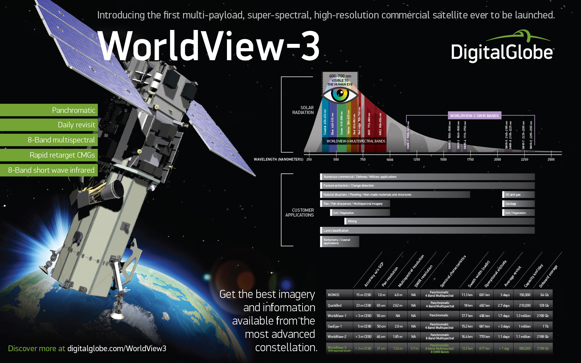
A few weeks ago, the U.S. Department of Commerce gave permission for DigitalGlobe—the Longmont, Colo.-based provider of commercial space imagery and geospatial content—to collect and sell Earth imagery at resolutions never before allowable under U.S. law. On 11 June, DigitalGlobe was permitted to sell images from its network of satellites at resolutions as fine as 16 inches (40 cm) panchromatic, far higher than the 20 inches (50 cm) previously permitted. On Wednesday, 13 August, when the WorldView-3 satellite is launched into orbit from Vandenberg Air Force Base, Calif., it will lay the groundwork to increase that resolution capability even further. From early 2015, DigitalGlobe will be able to sell geospatial imagery at resolutions never previously obtainable outside the military, as high as 10 inches (25 cm) panchromatic.
The implications are expected to be significant in their scope. As demonstrated in comparative aerial images of the California Academy of Sciences, courtesy of MapBox imagery specialist Charlie Lloyd, an increase from 20 inches (50 cm) to 16 inches (40 cm) from low orbit allows for the greater identification of features such as individual shrubs, the colors of people’s shirts, and the reading of smaller road markings. Six months after WorldView-3 is delivered by a United Launch Alliance (ULA) Atlas V rocket into a Sun-synchronous orbit of about 383 miles (617 km) above Earth, it will be in a position to push that imaging envelope yet further to 10 inches (25 cm) panchromatic and 3.3 feet (1 meter) multispectral resolution.
Launch of the Atlas V—which will fly in its “401” configuration, numerically designated to describe a 13-foot-diameter (4-meter) payload fairing, no strap-on rocket boosters, and a single-engine Centaur upper stage—is presently targeted to occur from Vandenberg’s Space Launch Complex (SLC)-3E at the start of a 15-minute “window,” which opens at 11:30 a.m. PDT Wednesday. This pad was most recently employed for the Defense Meteorological Satellite Program (DMSP)-19 mission in April 2014 and has supported dozens of launches since July 1961. According to ULA’s Twitter feed, weather conditions are expected to be 60 percent favorable.
At the time of writing, the impending milestone for the 196-foot-tall (60-meter) Atlas V is an approximately 35-minute rollout from the Vertical Integration Facility (VIF) to the SLC-3E pad surface. This will be followed by a flurry of activity to establish pad connections, perform pneumatic and other checks, and verify the performance of the Atlas’ flight control systems. The vehicle will undergo extensive testing of its ground commanding and communications systems, and its fuel lines will be purged with inert gaseous nitrogen, ahead of loading its propellants: a mixture of liquid oxygen and a highly refined form of rocket-grade kerosene, known as “RP-1.” About an hour before the opening of Wednesday morning’s window, the propellant tanks will be full and liquid oxygen will transition to a “topping” mode, being continuously replenished until near launch time.

After a final poll of the status of all stations, the Launch Director will authorize a “Go for Launch” at the last scheduled hold point at T-4 minutes and the so-called “Terminal Count” will get underway. Under its auspices, the Atlas V’s autosequencer will assume primary command of all vehicle critical functions through liftoff. Liquid oxygen replenishment will come to an end, the fuel and oxidizer valves will be closed for flight, and propellant tanks will be verified at Flight Pressure.
At T-5 seconds, sound-suppressing water will flood across the SLC-3E pad surface and into the flame trench, in order to minimize reflected energy and acoustic waves at the instant of liftoff. The ignition sequence of the Atlas V’s single, Russian-built RD-180 engine will commence at T-2.7 seconds, punching out 860,000 pounds (390,000 kg) of thrust, and the vehicle will be committed to flight at 11:30 a.m. PDT. The rocket, whose thrust-to-weight ratio is only 1:16, will lumber off the pad at T+1.1 seconds and climb vertically for the first 16 seconds of the mission. At this stage, the Centaur avionics will command a pitch, roll, and yaw program maneuver to actively guide the stack onto the proper flight azimuth to insert the WorldView-3 satellite into its Sun-synchronous orbit of 383 miles (617 km).
About four minutes into the flight, the RD-180 engine will be shut down and the 41-foot-long (12.4-meter) Centaur and attached WorldView-3 payload will be detached from the rapidly ascending vehicle. The next phase of the flight will incorporate a single “burn” of the Centaur’s 22,300-pound (10,100-kg) RL-10A liquid oxygen/hydrogen engine to establish the satellite in its correct orbit. During this period, the two-piece (or “bisector”) payload fairing will be jettisoned, exposing WorldView-3 to the space environment for the first time, and the satellite will be released into free flight about 19 minutes after launch.
Headquartered in Longmont, Colo., DigitalGlobe was founded in 1992 as WorldView Imaging Corp. by Dr. Walter Scott—who today serves as the company’s executive vice president and chief technical officer—and received the first high-resolution commercial remote sensing satellite license in 1993, under the provisions of the 1992 Land Remote Sensing Policy Act. Two years later, it was renamed EarthWatch, Inc., merging WorldView with the commercial remote sensing operation of the major defense and space contractor Ball Aerospace, also based in Colorado. The license from the U.S. Department of Commerce enabled the construction by Ball of the Early Bird-1 satellite, which was delivered into orbit atop a Start-1 booster from the Svobodny Cosmodrome in Russia’s Far East in December 1997. Its imaging payload was designed to deliver a panchromatic resolution of just 9.8 feet (3 meters) and a multispectral resolution of 49 feet (15 meters), but a power system failure caused the satellite to lose communications capability after just four days in flight.
Three years later, in November 2000, EarthWatch’s first QuickBird satellite—again built by Ball Aerospace and expected to deliver a panchromatic resolution as fine as 24 inches (60 cm) and a multispectral resolution of 8 feet (2.4 meters)—was lost following a launch failure out of the Plesetsk Cosmodrome in northern Russia. Success was finally achieved in October 2001, when a Delta II booster roared aloft from Vandenberg Air Force Base and delivered the replacement QuickBird-2 satellite into an orbit of 280 miles (450 km). Still in orbit today, QuickBird-2’s resolution produced a level of detail which enabled it to image buildings and other infrastructure at ground level. By the time of QuickBird-2’s launch, EarthWatch, Inc., had been renamed DigitalGlobe.
QuickBird-2 formed the initial element of a three-satellite complement. The second member of this constellation was WorldView-1, part-financed by the National Geospatial-Intelligence Agency (NGA), and was delivered into a 300-mile-high (490-km) orbit by ULA atop a Delta II rocket from Vandenberg in September 2007. Its panchromatic camera was capable of a resolution of 20 inches (50 cm), which made it the most powerful commercial imaging satellite of its time. Two years later, in October 2009, WorldView-2 was transported into an orbit of 480 miles (770 km), again atop a Delta II and again from Vandenberg, with the capability to achieve a panchromatic resolution of 18 inches (46 cm) and an eight-band multispectral resolution of 72 inches (184 cm). Both WorldView satellites are capable of revisiting the same place on Earth every 1.1 days.
Several months after the launch of WorldView-2, DigitalGlobe contracted to build a third satellite, and in August 2010 Exelis, Inc.—a global aerospace, defense, information, and services organization, based in McLean, Va.—was selected to develop its imaging payload. This initially consisted of a combination of panchromatic and Visible-Near-Infrared (VNIR) sensors, but was later expanded to include Short-Wave Infrared (SWIR), in order to accommodate more robust capability needs. In September 2013, Exelis delivered this “superspectral” telescope, sensor, and SWIR system for WorldView-3. Then, in January 2014, Ball Aerospace completed integration of the payload into the satellite and executed a series of system-level performance tests, thermal vacuum tests, and environmental tests.
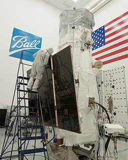
Physically, WorldView-3 closely resembles its immediate predecessor, WorldView-2, although it does boast a number of sensor enhancements, which have offered greater savings in terms of cost, risk reduction, and faster delivery of imagery to customers. Again built and integrated by Ball, the 6,200-pound (2,800-kg) satellite stands an impressive 18.7 feet (5.7 meters) tall and 8 feet (2.5 meters) in diameter, with a span of 23 feet (7.1 meters) across its two deployed solar array “wings.” These arrays will provide the three-axis-stabilized WorldView-3 with up to 3.1 kilowatts of electrical power, whilst its system of advanced Control Moment Gyroscopes (CMGs) will allow it to be reoriented over a desired imaging location in just 4-5 seconds, as opposed to the 30-45 seconds needed by traditional reaction wheels. The whole satellite is based upon the Ball Configurable Platform (BCP)-5000 spacecraft “bus” and can support the next generation of optical and Synthetic Aperture Radar (SAR) payloads. With a design life of at least 7.5 years, WorldView-3 may remain operational for more than a decade.
“Our experience building spacecraft for DigitalGlobe has allowed for quick progress on WorldView-3,” said Cary Ludtke, vice president and general manager of Ball Aerospace’s Operational Space business unit, quoted by Space Daily. “WorldView-3 will be a highly capable spacecraft based on a low risk design with proven results. We’re eager for it to join DigitalGlobe’s growing constellation.”
Yet it is the imaging capability of the satellite which has drawn most attention. For starters, WorldView-3’s orbit of 383 miles (617 km) is lower in altitude than its predecessors, roughly equivalent to the distance between Southern California’s Hollywood sign and the Golden Gate Bridge in San Francisco. “If the imagery were located at the Hollywood sign,” DigitalGlobe noted on its blog, “users would be able to count all of the people on the Golden Gate Bridge.” From this low altitude, the satellite will initially provide panchromatic and multispectral resolutions of 12.2 inches (31 cm) and 4 feet (1.24 meters)—expandable to 10 inches (25 cm) and 3.3 feet (1 meter) respectively, from early 2015—together with a SWIR resolution of 12.1 feet (3.7 meters). This is significantly finer than the 20 inches (50 cm) for panchromatic, 6.6 feet (2 meters) for multispectral, and 24.6 feet (7.5 meters) for SWIR permitted under U.S. law prior to June 2014. The result is that the WorldView-3 satellite will offer “an unprecedented level of ability and opportunity.” It will also revisit the same ground sites at least once daily and can cover 260,000 square miles (680,000 square km) in every 24-hour period.
Commenting on the relaxation of imaging regulations by the U.S. government, MapBox imagery specialist Charlie Lloyd noted a steady shift from the post-Cold War mindset of strictly controlling access to commercial imagery. “If tight resolution limits made sense two decades ago, they don’t anymore,” he explained, “and regulators are changing with the times. The second is that this isn’t just about San Francisco, New York City, Paris and other metropolises. Many of them already have satisfactory aerial imagery. This is about having ultra-high-res imagery and especially series of ultra-high-res imagery, over time, of anywhere in the world.”
“We are very pleased and appreciative that the U.S. Department of Commerce, under the leadership of Secretary Penny Pritzker, with support from the U.S. Departments of Defense and State and the Intelligence Community, has made this forward-leaning change to our nation’s policy that will fuel innovation, create new high-tech jobs, and advance the nation’s commanding lead in this strategically important industry,” said Jeffrey R. Tarr, DigitalGlobe’s chief executive officer. “Our customers will immediately realize the benefits of this updated regulation, as for the first time, we will be able to make our very best imagery available to the commercial market. As a result of this policy update and the forthcoming addition of WorldView-3 to our constellation, DigitalGlobe will further differentiate itself from foreign competition and expand our addressable market.”

In addition to its panchromatic and multispectral sensors, the satellite also features DigitalGlobe’s first atmospheric sounder. The 12-band Cloud, Aerosol, Water Vapor, Ice and Snow (CAVIS) instrument, built by Ball Aerospace, will allow WorldView-3 to gather data based upon ground reflectance characteristics, enabling it to correct its images for atmospheric effects, such as haze, soot, dust, and other contaminants. The CAVIS instrument will have a resolving power of about 100 feet (30 meters) and, in terms of its design and development, can trace its ancestry back to the Operational Land Imager (OLI) aboard NASA’s Landsat-8 spacecraft, launched in February 2013. Together with the atmospherically compensated capability of CAVIS, and coverage across no fewer than 16 spectral bands, WorldView-3 will offer important insights in various agricultural processes, such as crop-mapping, as well as gas and oil site selection and exploration and mining applications. Mapping, land classifications, disaster preparedness and response, soil and vegetation analysis, geology uses, environmental monitoring, and coastal applications will also be possible through the satellite’s data, according to Craig Oswald, commercial imaging manager of geospatial systems at Exelis.
“With each successive payload developed in partnership with Ball, DigitalGlobe has expanded the range of questions about the surface of the earth that can be answered with high-resolution satellite imaging,” said the company’s founder and chief technical officer, Dr. Walter Scott. “DigitalGlobe prides itself on owning and operating one of the most agile and sophisticated constellations of high-resolution commercial earth imaging satellites in the world, currently capable of collecting over 386 million square miles (1 billion square km) of the highest quality imagery per year. WorldView-3 follows in this pioneering tradition with innovations like CAVIS that continue to enable DigitalGlobe to lead the industry and help our customers see things never before possible.”
In January 2013, DigitalGlobe purchased one of its key competitors, GeoEye, Inc. (formerly Space Imaging), which had launched the Ikonos satellite into orbit in September 1999. Ikonos became the first satellite to collect publicly available imagery at 3.3 feet (1 meter) and 13.1 feet (4 meter) resolutions. More recently, in September 2008, GeoEye also launched the GeoEye-1 satellite, which has the capability to achieve a resolution of 16 inches (41 cm) for U.S. government purposes and up to 20 inches (50 cm) for its commercial users, chiefly Google Earth. Prior to its acquisition by DigitalGlobe, the company planned a follow-on GeoEye-2 satellite—with an imaging capability as fine as 12.2 inches (31 cm)—which is being retained in storage until needed. Originally targeted to fly in 2013, GeoEye-2 will take on the new name of “WorldView-4” when it is eventually launched.
Wednesday’s launch of the WorldView-3 mission represents the 10th of 15 planned flights by ULA in an action-packed 2014. To date, the Centennial, Colo.-based launch services provider—formed in December 2006 between Boeing and Lockheed Martin—has delivered payloads into orbit on behalf of NASA and the U.S. military. These have included NASA’s latest Tracking and Data Relay Satellite (TDRS) in January and the second Orbiting Carbon Observatory (OCO-2) in July, together with a Defense Meteorological Satelllite Program (DMSP) in April, two classified National Reconnaissance Office (NRO) payloads in April and May, the long-delayed Air Force Space Command (AFSPC)-4 mission in July, and no less than three Global Positioning System (GPS) Block IIF satellites in February, May, and most recently on 1 August. Following Wednesday’s scheduled launch of WorldView-3, ULA anticipates lofting the top-secret CLIO mission in September, another GPS Block IIF satellite in October, the Soil Moisture Active Passive (SMAP) spacecraft in November, and, in the first half of December, another classified NRO payload and the long-awaited Exploration Flight Test (EFT)-1 of NASA’s Orion spacecraft.
Want to keep up-to-date with all things space? Be sure to “Like” AmericaSpace on Facebook and follow us on Twitter: @AmericaSpace
Missions » WorldView 3 »
Is that a radiation symbol I see on the first image of the satellite in this article? Or am I just being paranoid? Because I note the satellite has two big solar panels.
Looks more like a port. Notice each of the visible panels have 2.
Im afraid of the Russian-built RD-180 engine, watch http://www.imagesatintl.com/
HERMENEUTICS-BY STEVE FINNELL
Hermeneutics is the science of interpretation of the Scriptures. Isolating verses of Scripture to prove a point of doctrine is common practice, but is it a valid scientific approach to understanding God’s word?
Let us examine this approach when dealing with the question, “WHAT MUST I DO TO BE SAVED?”
John 3:16 For God so loved the world that He gave His only begotten Son, that whoever believes in Him shall not perish, but have eternal life.
Is that verse true? Yes, but does it include all the requirements for salvation? No, it does not.
Mark 16:16 He who has believed and been baptized shall be saved; but he who has disbelieved shall be condemned.
Is that verse true? Yes, but does it include all the requirements for salvation?
Romans 10:9 that if you confess with your mouth Jesus as Lord, and believe in your heart that God raised Him from the dead, you will be saved.
Yes, that verse is true; but does include all the requirements for salvation?
John 3:5 Jesus answered, Truly, truly, I say to you, unless one is born of water and the Spirit he cannot enter into the kingdom of of God.
Is that verse true? Yes, but it does not explain the process to be born of water and the Spirit.
Ephesians 2:8 For by grace you have been saved through faith; and that not of yourselves, it is the gift of God;
Is that verse true? Yes, we have the opportunity for salvation because of God’s grace, however, that verse does not say that we are saved by grace alone nor does it say we are saved by faith only.
Romans 6:4-5 Therefore we have been buried with Him through baptism into death, so that as Christ was raised from the dead through the glory of the Father, so we too might walk in the newness of life. 5 For if we have become united with Him in the likeness of His death, certainly we shall also be in the likeness of His resurrection,
Is that verse true? Yes, but baptism alone is not the only requirement in order to walk in newness of life.
1 Peter 3:21 Corresponding to that, baptism now saves you—not the removal of dirt from the flesh, but an appeal to God for a good conscience—through the resurrection of Jesus Christ.
Is it true that water baptism saves us? Yes, but that verse does not say baptism alone saves us.
Acts 22:16 Now why do you delay? Get up and be baptized, and wash away your sins, calling on His name!
Is that verse true? Yes, but does it list all the requirements for salvation?
Galatians 3:27 For all of you who were baptized into Christ have clothed yourselves with Christ.
Is that verse true? Yes, but only if faith precedes baptism.
Acts 2:38 Peter said to them, “Repent, and each of you baptized in the name of Jesus Christ for the forgiveness of your sins; and you will receive the gift of the Holy Spirit.
Is that verse true? Yes, but it does not mean that you can have your sins forgiven without having faith and confessing Jesus as Lord and Savior.
Acts 16:30-31…”Sirs what must I do to be saved?” 31 They said, “Believe in the Lord Jesus, and you will be saved, you and your household.”
Is that verse true? Yes, however, it does not state that men are saved by “faith only.”
—————————————————————————-
The Bible says we saved by grace. It does not state we are saved by grace alone.
The Bible says we we are saved by believing in Jesus. It does not say we are saved by faith only.
The Bible says we are saved by confessing Jesus as Lord and believing that God raised Him from the dead. It does not say that by confessing Him and believing in His resurrection alone that we will be saved.
The Bible does says we must repent in order to have our sins forgiven. The Bible does not repentance alone saves us.
The Bible teaches us that water baptism is for the forgiveness of sins and that it saves us. It does not say baptism alone saves us.
WE ARE SAVED BY?
We are saved by grace.
We are saved by faith.
We are saved by repentance.
We are saved by confession.
We are saved by water baptism.
WHICH REQUIREMENT OF GOD’S PLAN FOR OUR SALVATION CAN WE ELIMINATE AND STILL BE SAVED?
The jailer and his household believed and were baptized that very hour. (Acts 16:30-33) There was no law keeping nor good deeds required for them to be saved.
YOU ARE INVITED TO FOLLOW MY BLOG. http://steve-finnell.blogspot.com