Almost exactly 3900 Sols into her planned three-month mission, NASA’s world-renowned Opportunity rover climbed proudly atop the tallest Martian mountain she will ever ascend, achieving a “milestone that can’t be underestimated,” Prof. Steve Squyres, the rover’s Science Principal Investigator of Cornell University, said exclusively to AmericaSpace, today, soon after signals were received that the astonishing event took place.
“Yes, we’re at the summit,” confirmed Squyres, who has led the rover mission during more than a decade and a half of conception, development, launch, landing, and breathtaking science operations across the stunningly beautiful but inhospitable surface floor of the alien Red Planet. See Mars as it looks today in our exclusive new mosaic above.
“The symbolic value of reaching a major summit on Mars eleven years into a 90-day mission can’t be underestimated,” noted Squyres. And it’s especially gratifying because the rover has suffered some significant problems recently with the flash memory and been somewhat “crippled.”
“We’re having difficulties with our aging flash memory, and until we can correct the problem we’re operating the vehicle in a ‘crippled mode’ that bypasses flash completely.”
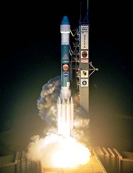
The six-wheeled Opportunity rover has reached the summit of Cape Tribulation nearly 11 years after her daunting air-bag assisted and bouncing ball touchdown on 24 January 2004 on Mars, and rolling to a stop after falling inside Eagle crater. It amounted to a 250-million-mile hole-in-one!
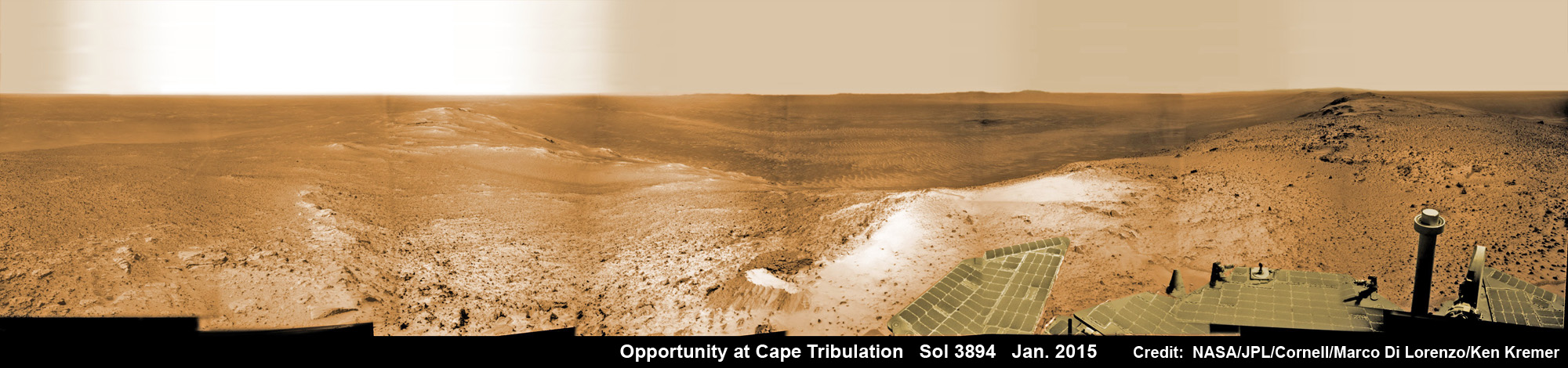
“The drive that put us on the summit was executed on Sol 3894 [Jan. 6, 2015],” said Squyres.
“I am tremendously happy and proud of the team!”
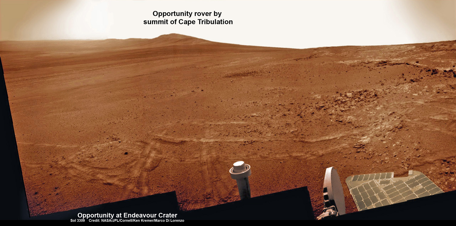
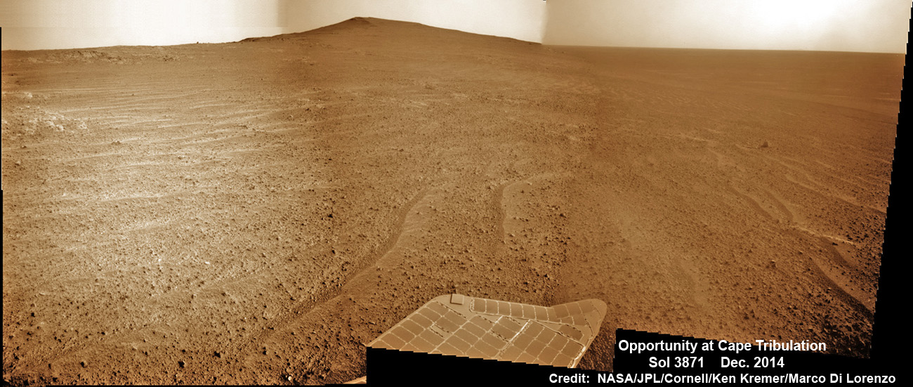
Initial images reveal a spectacular view from the summit. See above our brand new panoramic mosaic compilation view from Sol 3894—where the rover sits right now!—created for AmericaSpace by Marco Di Lorenzo and Ken Kremer.
Humanity’s longest living rover reached the summit of Cape Tribulation while traversing southward along gigantic Endeavour crater. This counts as the highest Martian mountain she will ever scale in her unbelievably incredible and momentous life of exploration and discovery.
NASA’s long-term goal is to send Humans to Mars in the 2030s, and Opportunity and sister rover Curiosity are paving the path to the Red Planet.
As of today, the rover stands at an elevation of about 1380 meters overlooking humongous Endeavour crater, spanning some 22 kilometers (14 miles) in diameter.
So the view is incomparable to anything we’ve seen thus far.
Additional high-resolution imagery is being taken now by the Pancam camera.
“It should be a great view into the crater, along the rim, and of the rocks that form the summit,” said Squyres.
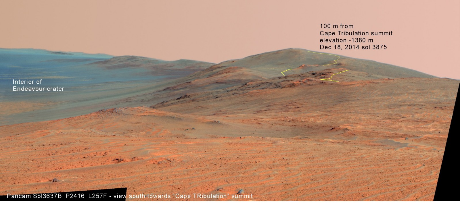
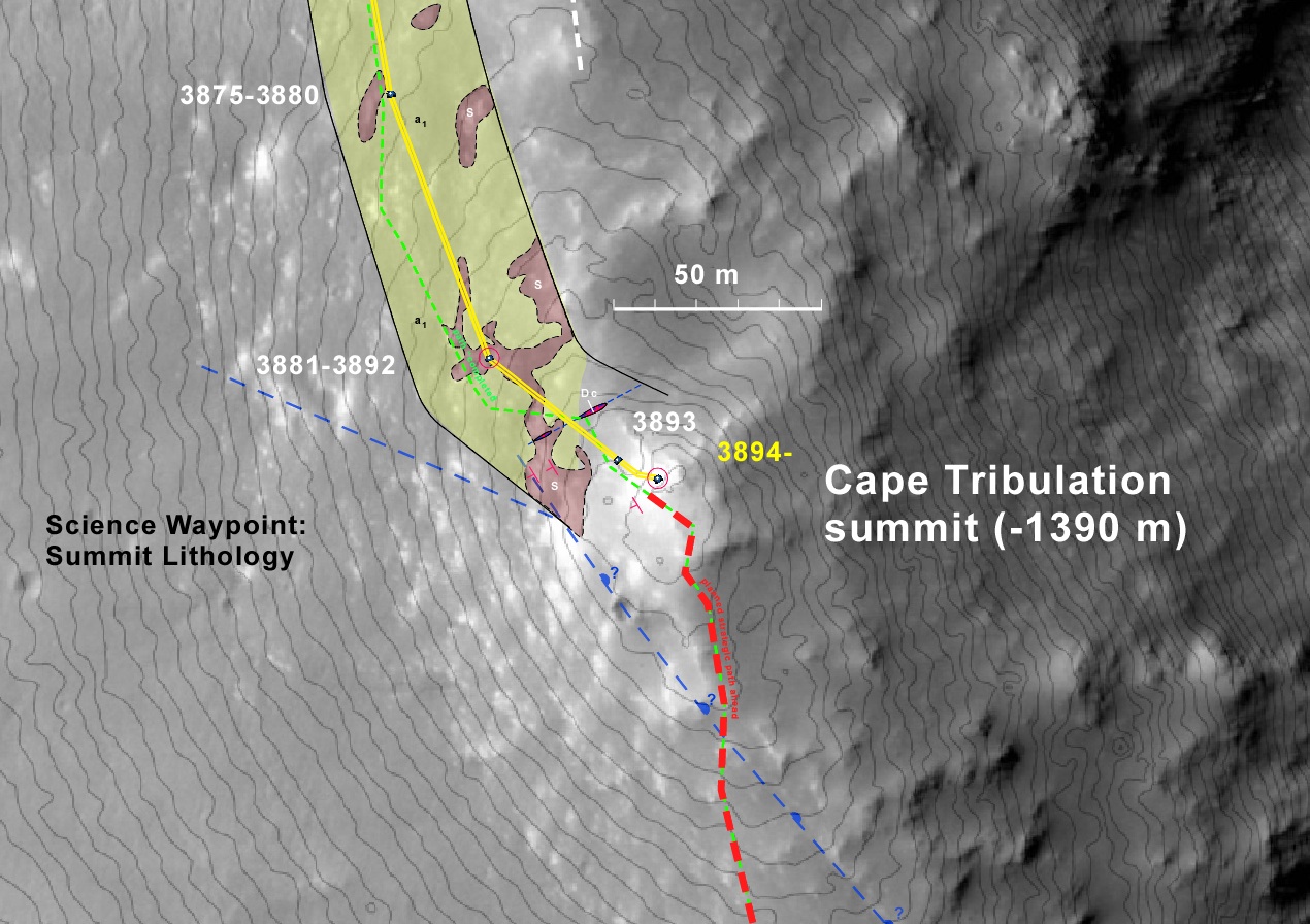
The mountain peak is called “Summit Lithology,” Prof. Ray Arvidson, the rover Deputy Principal Investigator of Washington University told AmericaSpace.
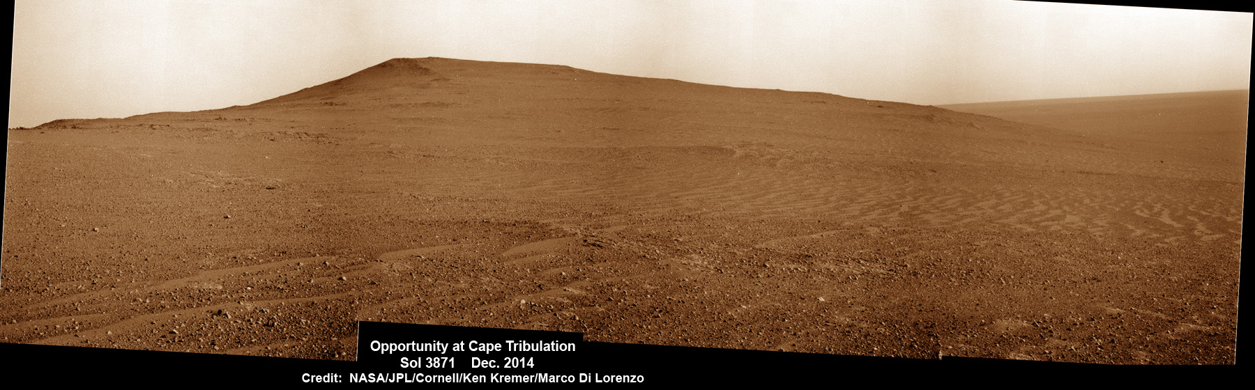
Cape Tribulation is located along the eroded western rim segment of Endeavour crater.
She arrived at Endeavour in August 2011 at another rim segment to the north named “Cape York” after a multiyear traverse across the plains of Meridiani Planum.
Furthermore, Opportunity has accomplished the first overland expedition across the surface of another planet. Mars is the most Earth-like planet in our Solar System.
You can see the entire 11-year overland traverse of Opportunity and her current location in our exclusive route map below.
“A spectacular Pancam view was returned on sol 3894 showing Shoemaker formation brecccias and part of the crater interior,” Arvidson explained.
Opportunity will likely spend the remainder of her robotic life traveling around and investigating Endeavour’s magnificent and vast expanse.
Reaching the crater rim peak at last is an especially sweet feat for the team, because the daunting task was accomplished while the rover suffered a series of near crippling “amnesia” events in recent months of the ascent.
“I think this milestone is particularly significant because we accomplished the steepest and hardest parts of it in what we call ‘crippled mode’. We’re having difficulties with our aging flash memory, and until we can correct the problem we’re operating the vehicle in a mode that bypasses flash completely,” Squyres elaborated.
So the team was resourceful in the face of a big challenge and developed workarounds to save the rover and the science!
“What that means is that after each sol’s activities, any data not downlinked immediately is lost forever. This requires a very different way of operating the vehicle, and the team has mastered it.”
“We expect to address the flash problem in the near future, but what this accomplishment shows is that the rover is not crippled in ‘crippled mode’. It’s just a little forgetful. :)”
Now that Opportunity has climbed atop the mountain, the rover is collecting images and spectral data and reevaluating the way forward plan.
“We will get additional Pancam color data. How much is being considered as we communicate with one another,” Arvidson explained.
“The area looks very much like a sediment shaped by wind. Thin soil cover, with cobbles, over bedrock.”
“The scientific value of reaching the summit depends on the lithology of the rocks there, and we haven’t made that measurement yet,” Squyres added.
What observations are planned at the peak in the near term?
“A big Pancam panorama, of course, and then a closer looks at the summit rocks if the Pancams suggest it’ll be worthwhile,” replied Sqyures.
The real science riches lie about a half a kilometer beyond and down slope, in an area called “Marathon Valley.”
“We are about 500 meters from ‘Spirit of Saint Louis’ crater at the entrance to Marathon Valley (named because the rover will have traveled one marathon’s distance to reach it)!” said Arvidson.
Arriving at Cape Tribulation has been a long-sought goal of the science team because it puts the six-wheeled rover by a region of clay minerals that’s a scientific goldmine. The phyllosilicate clay minerals formed in neutral liquid water billions of years ago when the Red Planet was far warmer and wetter and thus much more conducive to the formation of Martian microbes, if they ever existed.
What’s the driving and science plan ahead?
“Well, the next major stop after this one will be ‘Spirit of St. Louis’ crater, which lies to the west of Marathon Valley,” Squyres replied.
“And then into Marathon Valley itself.”
“The view at the summit is spectacular,” according to rover science team member Larry Crumpler, of the New Mexico Museum of Natural History & Science (NMMNHS), in an update.
“From here we can see all the way to the other side of the crater, we can see the rim looking north along the path to this location, and we can see far to the south, including another large impact crater that lies 10 km or so south of Endeavour.”
The ancient, weathered slopes of Cape Tribulation hold a motherlode of the “phyllosilicate” clay minerals, based on data obtained from the extensive orbital measurements made by the CRISM spectrometer accomplished earlier at the direction of Arvidson.
The clay minerals were detected from orbit by the CRISM spectrometer aboard NASA’s powerful Martian “Spysat”—the Mars Reconnaissance Orbiter (MRO)—while gathering context data at rock outcrops along the long and winding way over the past few years.
The robot’s science team specifically directed Opportunity toward Cape Tribulation several years ago, based on the detection of abundant exposures of aluminum-rich clay minerals at a spot a bit beyond the summit called “Marathon Valley,” using the spectral measurements from CRISM and MRO.
The clay minerals are now in the line of sight of Opportunity, and the science team is bursting with excitement back here on Earth.
Today, 8 January 2015, marks Opportunity’s 3894th Sol or Martian day roving Mars. So far she has snapped over 199,600 amazing images since her air-bag assisted touchdown on 24 January 2004 inside Eagle crater.
Opportunity’s total odometry is over 25.73 miles (41.42 kilometers).
Stay tuned here for continuing developments from Earth’s invasion fleet at Mars.
Want to keep up-to-date with all things space? Be sure to “Like” AmericaSpace on Facebook and follow us on Twitter: @AmericaSpace
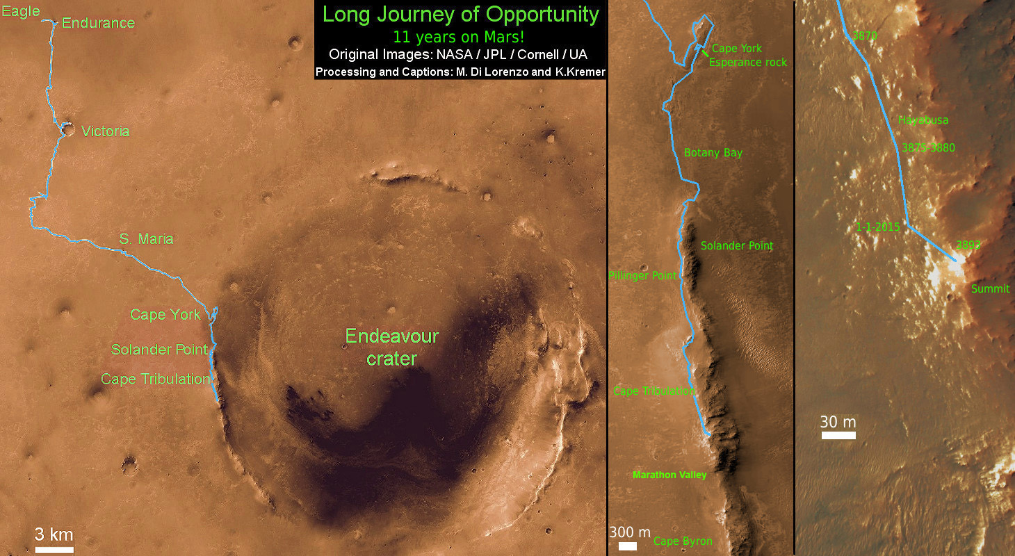
This map shows the entire path the rover has driven during a decade on Mars and over 3894 Sols, or Martian days, since landing inside Eagle Crater on Jan 24, 2004 to current location by Cape Tribulation summit at the western rim of Endeavour Crater. Opportunity discovered clay minerals at Esperance – indicative of a habitable zone – and is searching for more at Cape Tribulation. Credit: NASA/JPL/Cornell/ASU/Marco Di Lorenzo/Ken Kremer – kenkremer.com
Beautiful and sesation.
beautiful and Sensation-Photos
This shows what we can do when we put our minds to it! Now to stop war!
Stunning! Absolutely incredible!
I am starting up a internet website directory and was wondering if I can submit your website? I’m hoping to mature my directory little by little by hand so that it maintains top quality. I will make sure and put your blog in the correct category and I’ll additionally use, “” as your anchor text. Please make sure to let me know if this is ok with you by contacting me at:. Thanks!
nairmax2015.net http://www.nairmax2015.net