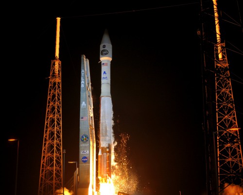
Four decades of critical observations of the Home Planet will continue in spectacular style on Monday, 11 February, with the scheduled liftoff of the Landsat Data Continuity Mission (LDCM) from Vandenberg Air Force Base, Calif. This is the eighth satellite in a lengthy collaborative effort between NASA and the U.S. Geological Survey, and it will provide moderate-resolution observations of Earth’s terrestrial and polar regions at visible and infrared wavelengths. Like its predecessors, the data from LDCM will support future land planning, disaster response, water-use monitoring, and, more generally, keep watch over the planet’s climate, its ecosystems, its water cycle, and its surface and interior. Liftoff is presently scheduled to occur from Vandenberg’s Space Launch Complex (SLC)-3 during a 48-minute window on Monday, which opens at 10:02 a.m. PST (1:02 p.m. EST).
Originally conceived in the mid-1960s as the Earth Resources Technology Satellite, one of the Landsat program’s fundamental instruments—its multispectral scanner—was completed and tested a few months after Neil Armstrong and Buzz Aldrin walked on the Moon. The first mission in the series roared into near-polar orbit on 23 July 1972, also from Vandenberg, and three years later the project’s name was changed to “Landsat.” Solar overheating caused it to be shut down in January 1978, but it was merely the start of a remarkable journey.
Landsats 2 and 3 continued to function, well beyond their planned one-year operational life spans, but the arrival of Landsat 4 in mid-1982 brought disappointment: shortly after launch, it lost half of its electrical power, together with its ability to transmit science data. To compensate for this loss, a backup spacecraft, Landsat 5, was boosted into orbit in early 1984. At one stage, plans were advanced to launch a shuttle mission from Vandenberg in March 1987 to retrieve, repair, and refuel Landsat 4, but these were shelved in the wake of the Challenger tragedy. However, with the arrival of NASA’s Tracking and Data Relay Satellite network, Landsat 4 rallied and even aided Landsat 5 for a time in 1987 when the latter encountered its own problems. Landsat 4 marked the program’s first use of the Thematic Mapper, which gathered seven spectral bands of data and achieved far higher resolution than its predecessors. Not until the end of 1993 was it finally decommissioned.
As for Landsat 5, it continues to function to this day, although it has suffered serious difficulties in recent years: an anomaly with its backup solar array drive, troubles with power and attitude control, and, more recently, in November 2011, fluctuations in a critical data-transmission amplifier. Some months ago, the U.S. Geological Survey announced that it was nearing the end of its life, after almost three decades—and 25 years longer than intended—of active science operations. Landsat 6 failed to reach orbit in late 1993, and the most recent arrival, Landsat 7, was successfully launched in April 1999. Despite a malfunction in its Enhanced Thematic Mapper, Landsat 7 continues to operate, but the arrival of LDCM to take up the baton is acutely needed.
“Landsat has given us a critical perspective on our planet over the long term and will continue to help us understand the big picture of Earth and its changes from space,” NASA Administrator Charlie Bolden said last year, in commemoration of the program’s 40th anniversary in July 2012. “With this view, we are better prepared to take action on the ground and be better stewards of our home.” Interior Department Secretary Ken Salazar added that the 40-year Landsat archive “forms an indelible and objective register of America’s natural heritage” and lauded it as a “legacy to the American people.”
It has even produced an island, 12 miles off the northeast coast of Labrador, named in its honour. “Landsat Island” was found in 1976, during a Canadian survey which utilized Landsat 1 data to find uncharted landmarks. Lowered by a helicopter harness, Dr. Frank Hall of the Canadian Hydrographic Service narrowly missed being swiped by a polar bear and thus almost became the first person to meet his maker on the island.
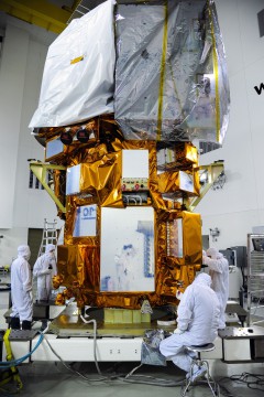
With next week’s launch of LDCM, Landsat will continue a proud record … and a free record, at that, for its data is freely available to investigators and the wider public for agriculture, geology, forestry, regional planning, education, mapping, and global change research. The new mission is equipped with two scientific instruments. The Operational Land Imager is sensitive to the visible, near-infrared and shortwave-infrared part of the electromagnetic spectrum. Its images have 50-foot panchromatic and 100-foot multispectral spatial resolutions along a 115-mile swathe, allowing it to cover wide areas, yet still enabling it to adequately view urban centers, farms, and forests. Meanwhile, the satellite’s Thermal Infrared Sensor will measure land surface temperatures in two thermal bands, using quantum well infrared photodetectors to detect long wavelengths of light emitted by the Earth.
Due to LDCM’s near-polar orbit, the entire planet will fall within view every 16 days. Not surprisingly, LDCM represents something of a capability leap, in that it will return more than 60 percent more imagery to the U.S. Geological Survey’s data archive daily than Landsat 7. No fewer than 400 scenes will be downlinked from the new satellite every day, compared to 250 for its predecessor. This is expected to increase the probability of capturing cloud-free scenes for the global land mass.
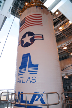
Monday’s launch from Vandenberg will occur atop ULA’s Atlas V, which is flying in its pencil-like “401” configuration, with a 4-meter (13-foot) payload fairing, no strap-on rocket boosters and a single-engine Centaur upper stage. These will insert LDCM into its operational near-polar orbit at an altitude of around 438 miles, inclined 98.2 degrees to the equator. The 401 configuration is identical to that adopted for NASA’s latest Tracking and Data Relay Satellite (TDRS-K), which was successfully boosted into orbit from Cape Canaveral Air Force Station, Fla., on 30 January. Processing of the flight hardware—and of the LDCM spacecraft itself, which arrived at the California launch site just before Christmas—has moved ahead crisply and with exceptional smoothness.
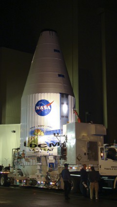
The Atlas was erected on the SLC-3 pad surface in mid-October 2012, and a fully-fueled (or “wet”) countdown demonstration test with liquid oxygen and hydrogen and a refined form of rocket-grade kerosene, known as “RP-1,” was performed in early December. By this time, the LDCM payload fairing had also arrived at Vandenberg, and on the 19th the satellite arrived in an oversized semi-trailer truck from prime contractor Orbital Sciences Corporation’s Gilbert, Ariz., facility. Last month, LDCM underwent comprehensive performance tests of its twin scientific instruments, its systems, and its solar arrays, and its X-band communications antenna was installed. By mid-January, the spacecraft had been fueled and was encapsulated within its payload fairing on the 23rd. Two days later, at 6:25 a.m. PST (9:25 a.m. EST), it was transported to SLC-3 for integration atop the 19-story Atlas.
The impending launch will mark the second United Launch Alliance mission of the year, following last week’s rousing ascent of TDRS-K from the East Coast. Citing his ongoing commitment to “perfect product delivery,” ULA’s Vice President for Mission Operations Jim Sponnick noted that LDCM will mark the very first Atlas V flight from the West Coast in collaboration with NASA. Its near-polar, Sun-synchronous orbit requires the launch vehicle to follow a due-south trajectory from SLC-3. Mission telemetry data during ascent and orbital injection will be gathered by tracking stations at Vandenberg, the Hawaiian island of Oahu, RAF Oakhanger in Hampshire, U.K., and Thule Air Base in Greenland.
Two-and-a-half seconds before liftoff, the Atlas V’s Russian-built RD-180 engine will roar to life, spooling up to its full 860,000 pounds of thrust by T-zero. This engine is fed by liquid oxygen and RP-1 and is scheduled to burn for four minutes. Climb-out from SLC-3 will commence at T+1.1 seconds. Shortly after clearing the tower, the Atlas will execute a combined pitch, roll, and yaw maneuver, which will position it onto the proper flight azimuth for the insertion of LDCM into orbit. A little over a minute into the flight, with the RD-180 still burning hot and hard, the vehicle will burst through the sound barrier. At around this time, maximum aerodynamic stresses will be felt through the Atlas’ airframe.
Slightly ahead of RD-180 cut-off, at T+242 seconds, the engine will be throttled back to limit acceleration loads and, upon its separation, the turn will come of the 41-foot-long Centaur. The latter’s RL-10A engine, built by Pratt & Whitney Rocketdyne, is responsible for the emplacement of LDCM into orbit. This engine was at the center of a lengthy investigation last year, following an incident of abnormally low thrust during its otherwise successful effort on 4 October to insert a Global Positioning System (GPS) satellite into orbit. It is capable of restarting in flight and will support two “burns” to deliver its primary payload. The first burn will last for a little over 11 minutes and will serve to place the LDCM/Centaur into a “parking orbit,” after which the combo will coast for 55 minutes, ahead of a second burn, lasting a little under two minutes. Shortly after the completion of this second burn, and 78 minutes after leaving Vandenberg Air Force Base, the 6,100-pound LDCM will separate from the Centaur to begin the complex process of deploying its solar arrays and appendages.
Its mission is expected to last five years, but judging from Landsat’s previous record it will undoubtedly eclipse this target. Landsat 5 remained functional for more than a quarter of a century and Landsat 7—though aging now—continues to return tremendously valuable scientific data. “LDCM will be the best Landsat satellite yet launched in terms of the quality and quantity of the data collected by the LDCM sensors,” said Project Scientist Jim Irons of NASA’s Goddard Space Flight Center at Greenbelt, Md. He stressed that the mission’s twin scientific instruments will “employ technological advances” which will make observations correspondingly “more sensitive to the variation across the landscape and to changes in the land surface over time.” After several weeks of inaugural checkout, the U.S. Geological Survey will assume operational control of LDCM, which will receive the numerical designation of “Landsat 8.”
One Comment
One Ping
Pingback:Euphoria as NASA’s New Landsat Earth-Watcher Finally Flies « AmericaSpace