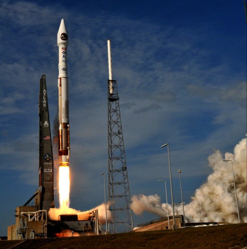
United Launch Alliance’s venerable Atlas V booster is set to roar aloft on 15 May on a mission to place the Global Positioning System (GPS) IIF-4 satellite into medium orbit, more than 11,000 miles above Earth. The new mission will keep the Navstar network of worldwide positioning, velocity, and timing assets fully operational until the next-generation GPS Block IIIA comes online, sometime in 2014. Liftoff of the Atlas V—which will fly in its “401” configuration, with a 4-meter-wide (13-foot) payload fairing, no strap-on rocket boosters and a single-engine Centaur upper stage—is scheduled to occur within a short “window,” extending from 5:38-5:56 p.m. EDT Wednesday. Notably, this will be the first GPS launch aboard an Atlas in almost 28 years.
Processing of the Atlas and payload at Cape Canaveral Air Force Station, Fla., continues to go well, and the vehicle is expected to be transferred to Space Launch Complex (SLC)-41 Tuesday. The 401 configuration has already been used three times in 2013 to launch NASA’s latest Tracking and Data Relay Satellite (TDRS-K) in January, the Landsat Data Continuity Mission (LDCM) in February, and most recently the Space-Based Infrared System for Geosynchronous Orbit (SBIRS GEO-2) on 19 March. Since its maiden voyage in August 2002, the Atlas V has flown 37 times, with a near-perfect record. Its sole blemish was a Centaur upper stage glitch in June 2007, which produced a lower than intended orbit for its classified National Reconnaissance Office primary cargo. Capped-off by a bulbous, two-piece (“bisector”) payload shroud, the vehicle stands 19 stories tall.
Wednesday’s mission will mark the first time in almost 28 years that an Atlas has ferried a GPS satellite into orbit. The last occasion was on 9 October 1985, when an Atlas E/F rocket boosted the GPS I-11 payload into space from Vandenberg Air Force Base, Calif. It is intended that the 12-satellite GPS IIF network will employ a mix of both Atlas V and Delta IV launches.
The Atlas’ Russian-built RD-180 engine, with a propulsive yield of 860,000 pounds, will ignite about 2.7 seconds ahead of liftoff, burning liquid oxygen and a refined form of rocket-grade kerosene, known as “RP-1.” Climb-out from SLC-41 will commence at T+1.1 seconds and the pencil-like booster will climb vertically for about 16 seconds, after which the avionics of the Centaur will command a pitch, roll, and yaw maneuver. This will establish the Atlas onto the proper flight azimuth of 45.8 degrees, following a north-easterly trajectory to insert the 3,600-pound GPS IIF-4 satellite into orbit. After the shutdown of the RD-180 at T+243 seconds, the 41-foot-long Centaur and attached payload will separate, preparatory to two “burns” to achieve a target 11,047-mile, 55-degree-inclined orbit.
Ignition of the Centaur’s 22,300-pound-thrust RL-10A engine for the first time will occur about ten seconds after the separation of the Atlas’ first stage. The engine employs cryogenic propellants of liquid oxygen and liquid hydrogen and is designed to be restartable in space. This first burn will be followed by the jettisoning of the two-piece payload fairing to expose GPS IIF-4 to the space environment for the first time. The first burn is expected to last about 13 minutes, after which the Centaur/payload combo will coast for almost three hours, ahead of a second burn, lasting just 1.5 minutes. Following the completion of this event, the Centaur will spin-up the payload to five revolutions per minute and release GPS IIF-4 at T+3 hours and 23 minutes.
Throughout the ascent phase, telemetry data will be gathered by the Eastern Range, together with various worldwide installations under the U.S. Air Force Space Control Network: New Boston Air Force Station, N.H., the Royal Air Force’s Oakhanger installation in Hampshire, England, Diego Garcia in the Indian Ocean, and Guam in the western Pacific Ocean. Additionally, NASA’s Tracking and Data Relay Satellite constellation will participate in the gathering of telemetry during the mission. From its semi-synchronous medium-altitude orbit, GPS IIF-4 will circle Earth once every 12 hours. It is expected to complete testing in August, after which it will be utilized as a “reserve” or “backup” satellite.
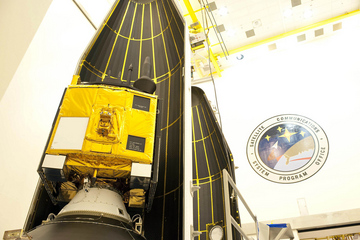
This latest global-positioning asset will mark the fourth satellite in a 12-strong network of GPS IIF spacecraft, the first of which was boosted into orbit in May 2010. A second spacecraft flew in July 2011, followed by last October’s launch of GPS IIF-3 atop a Delta IV Medium rocket. The GPS IIF-4 payload arrived at Cape Canaveral Air Force Station from prime contractor Boeing’s Satellite Development Center in El Segundo, Calif., aboard a C-17 Globemaster III aircraft on 26 February 2013. The GPS IIF boasts improved positioning, velocity, and timing accuracy, a reprogrammable processor, an interference-free civilian signal for commercial aviation search and rescue, and a new Military code (or “M-code”) to offer better resistance to electronic jamming. “As each IIF satellite becomes operational, we continue the seamless transformation of the GPS constellation into an even more accurate, reliable, and durable navigation resource for the U.S. military and the global civilian user community,” said Craig Cooning, vice-president and general manager of Boeing Space & Intelligence Systems. “Our efficient pulse-line manufacturing process, adapted from Boeing’s commercial airplane production lines, also ensures that we deliver each spacecraft on time and on cost.”
In the meantime, the U.S. Air Force expects the next-generation GPS IIIA network to enter service from 2014. It awarded a $1.4 billion contract to Lockheed Martin in May 2008 to develop this new network, which may eventually comprise as many as 32 satellites, although the Air Force has only formally contracted for four of these. With 500 times the transmitter power of current systems, the IIIA satellites will benefit from improved navigational warfare capabilities, enabling them to shut off GPS services to limited geographical locations, whilst maintaining service to U.S. and allied forces. The GPS satellite system is operated and controlled by the 50th Space Wing, located at Schriever Air Force Base, Colo.
Want to keep up-to-date with all things space? Be sure to “Like” AmericaSpace on Facebook and follow us on Twitter:@AmericaSpace
Missions » GPS » GPS IIF-4 »