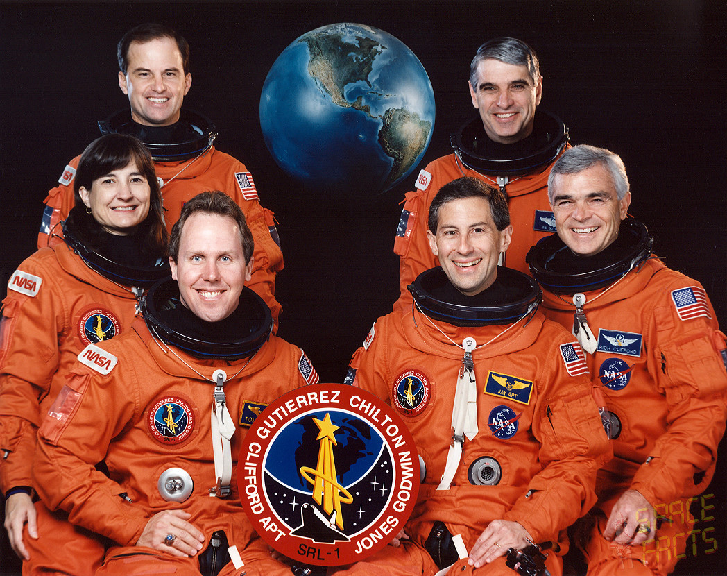
Twenty years ago this week, the crew of Endeavour on STS-59 demonstrated that the shuttle program was imbued with “Radar Love,” as they operated the first Space Radar Laboratory (SRL-1) to acquire unprecedented views of the Home Planet from orbit. For 11 days, astronauts Sid Gutierrez, Kevin Chilton, Jay Apt, Michael “Rich” Clifford, Linda Godwin, and Tom Jones worked around the clock to ensure that the radar instruments of the SRL-1 payload gathered an enormous quantity of scientific data. Much of that data is still being analyzed to this day and has helped to shape our understanding of Earth’s past, present, and, potentially, its future.
SRL-1 had its genesis in the Shuttle Imaging Radar (SIR), which first flew aboard STS-2 in November 1981. However, the capabilities of SIR-A were left undemonstrated, because the scheduled five-day mission was cut short by a fuel cell malfunction and shuttle Columbia returned to Earth after just 54 hours. Three years later, however, it flew again aboard Challenger on STS-41G as “SIR-B,” and its success provoked astonishment. Over an eight-day period in October 1984, it identified ancient caravan trails in Arabia, allowed geologists to construct three-dimensional maps of subtle features on California’s Mount Shasta, permitted contour modeling of parts of eastern and southern Africa, and examined intricate structural features, including fault-lines, folds, fractures, dunes, and rock layers.
By this time, at least two more missions of the shuttle-ferried radar were planned, but had been extensively delayed. On the eve of the Challenger disaster, SIR-C was scheduled to form part of SRL-1 and scheduled for launch on STS-72A in March 1987 from Vandenberg Air Force Base, Calif. The payload would have operated from a near-polar inclination of 88 degrees, offering its radar instruments a broad imaging swathe across most of Earth’s landmasses. In the aftermath of Challenger, all Vandenberg missions were suspended (and ultimately cancelled) and the launch site for SRL-1 changed to the Kennedy Space Center, Fla. This meant that the maximum achievable orbital inclination for the mission was 57 degrees. When NASA issued its January 1990 manifest, the launch of SRL-1 was not anticipated before the summer of 1992, and shuttle delays forced an inevitable slip into the last quarter of the following year.
When astronaut Linda Godwin was named as the SRL-1 payload commander in August 1991, the launch of her mission had moved forward slightly to the late summer of 1993. Six months later, “rookie” astronaut Tom Jones joined her as a mission specialist and the pair began a lengthy period of preparatory work on SRL-1, ahead of the assignment of the other four crew members.
In his memoir, Skywalking, Jones recounted the news of receiving this first assignment to a space mission. One February morning in 1992, he was summoned to the office of the Director of Flight Crew Operations, Don Puddy, at the Johnson Space Center (JSC) in Houston, Texas. Sat at the conference table with Puddy was Godwin. “I vaguely remembered that Linda had been assigned earlier to work on long-range planning for one of next year’s shuttle missions,” Jones wrote, “but I couldn’t recall which one.” Quickly, Puddy asked Jones if he would be prepared to serve as Godwin’s “science deputy” on SRL-1. Naturally, it was a question with only one answer, but Jones (who held a PhD in planetary science) would prove an invaluable asset on one of the most dramatic research missions of the decade.
Operating from an orbital inclination of 57 degrees, the payload’s imaging radar would map a substantial portion of Earth, including regions as far north as Juneau, Alaska, and a little farther south than Tierra del Fuego at the tip of Argentina. When the remaining four members of the SRL-1 crew—which had by now received the mission designation of “STS-59″—were announced in March 1993, only two of them had previous experience of such a high-inclination orbit—one of the highest ever attained by the shuttle. Mission specialists Jay Apt and Rich Clifford had flown 57-degree orbits on earlier flights and were acutely aware of its usefulness for Earth observations.
In fact, Apt wrote extensively about the experience in his book Orbit, co-authored with Justin Wilkinson and Michael Helfert. “On my first space flight,” Apt wrote, referring to STS-37, which operated at an inclination of 28.5 degrees, “I flew no farther north than the glorious Himalaya. I shot photo after photo of Tibet, with the Sun low in the sky and the shadows long. Central and northern Asia were a mystery to me. On my second and third flights, I was on the flight deck for a 12-hour shift, when it was “night” in Houston and “day” in Asia. We flew over almost the entire continent.”
From 57 degrees, Apt saw plumes of smoke from cellulose plants at the south shore of Lake Baikal, irrigation channels cutting across the Taklimakan Desert, multi-coloured soil tones in Kamchatka—the latter of which, he wrote, was “worth the trip up the north”—and the puzzling landscape of the Korean peninsula. Thousands of miles away, in the northern Americas, Apt beheld drifting volcanic ash from Mount Spurr in Alaska, together with the breathtaking grandeur of Yellowstone National Park and the geological variety of the western states. Elsewhere, northern Europe seemed to be almost completely covered by farmland, and during one pass over Australia, on STS-59, a woman on the ground relayed Apt’s ham radio signals to enable him to speak directly to cosmonaut Valeri Polyakov aboard the Mir space station. South America was most memorable for Apt, as he was able to see smoke and fires in Tierra del Fuego and Patagonia, presented to his eyes as far-off points of light. Even though he had flown to 57 degrees on STS-47, Apt found that lighting conditions were not good, with the shuttle’s windows pointed toward the Sun for most of the time, but SRL-1 benefited from much better conditions. In preparation for the immense amount of photography which would be conducted, alongside the radar observations, all six crew members became proficient in the use of appropriate camera lenses with consistent shutter speeds and light meters to determine proper exposure times.
To understand how the SRL-1 payload evolved, it is important to comprehend the accomplishments of the SIR-A and SIR-B radars. The first mission in November 1981 was restricted to recording the ground-track directly “beneath” the orbiter, but in preparation for SIR-B the radar was engineered to “tilt” at angles of between 15 and 57 degrees to the side and its imaging resolution was enhanced from 130 feet (40 meters) to 80 feet (25 meters). By varying its “look” angle in this fashion, it became possible to assemble “mosaics” of adjacent surface features, collected over periods of several days. The third mission, SIR-C, offered multi-frequency, multi-polarization imagery and represented the first spaceborne radar with the ability to transmit and receive horizontally and vertically polarised waves at both the L-band and C-band wavelengths.
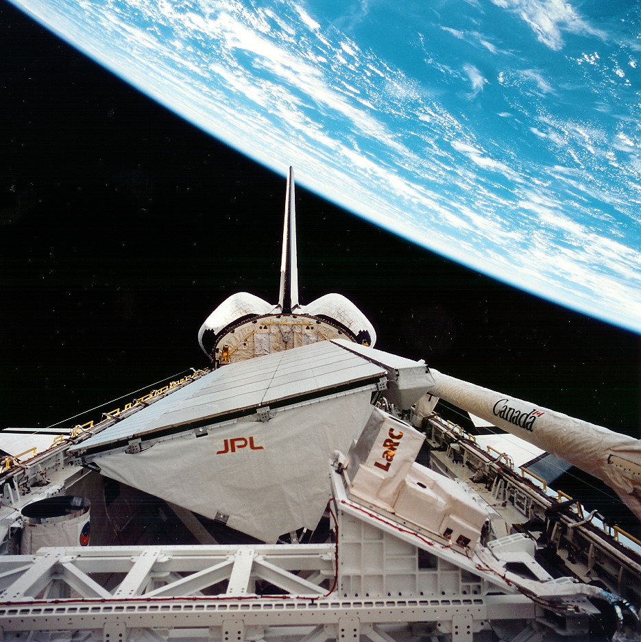
Measuring 39 feet (12 meters) long and 13 feet (four meters) wide and weighing 23,150 pounds (10,500 kg), SIR-C was the most massive piece of flight hardware ever built at the Jet Propulsion Laboratory (JPL) in Pasadena, Calif. It was a “synthetic-aperture” radar and, like a huge dining table, consumed almost half of shuttle Endeavour’s payload bay on STS-59. “Synthetic-aperture radar technology,” explained Tom Jones in his memoir, “uses the motion of a spacecraft or aircraft to electronically synthesize an antenna much larger than its physical size, yielding higher imaging resolution.” Originally assembled from spares left over from NASA’s 1978 Seasat mission, SIR-C was affixed to its own truss support structure, which, in turn, was mounted onto a Spacelab pallet, providing a “side-looking” viewing angle, some 47 degrees from the nadir. As a result, during data-gathering operations the shuttle was required to reorient itself to precisely direct SIR-C at its ground targets. Unlike the previous SIR missions, its radar beam was formed from hundreds of transmitters, embedded within the surface of the antenna. By properly adjusting the energy from these transmitted, the beam could be electronically “steered” and, when combined with shuttle maneuvers, offered the scope to acquire images from various directions.
However, SIR-C was not the only radar aboard SRL-1. Running like a strip along the uppermost edge of SIR-C was “X-SAR”—a 39-foot (12-meter) x 1.3-foot (0.4-meter) synthetic-aperture device, built by a partnership of organizations, including the German Dornier and Italian Aleniz Spazio companies, together with the German (DARA) and Italian (ASI) space agencies—which offered a single-polarization radar, operating in the X-band. X-SAR was a follow-on project from Germany’s Microwave Remote Sensing Instrument, flown aboard Spacelab-1 in late 1983. Its “slotted waveguide antenna” was finely tuned to produce a narrow energy beam, and X-SAR was designed to be mechanically aligned with the L-band and C-band beams of SIR-C.
Before launch, NASA’s SRL-1 press kit noted that resolutions as high as 33 feet (10 meters) were a possibility. Throughout the projected nine-day mission, the combined SIR-C/X-SAR imaging suite was expected to make around 50 hours of observations, covering more than 19.3 million miles2 (50 million km2), acquiring 32 terabytes of raw data, and storing it all on 180 cassettes, using three high-density, digital, rotary-head tape recorders. Both radars would work together to acquire the best possible data. For instance, the shorter-wavelength X-SAR data was expected to be particularly useful for the determination of snow types, with the L-band and C-band capabilities of SIR-C estimating snow volumes.

Although the United States, Germany, and Italy were involved in the development of the payload, more than 50 investigators from 13 nations (Australia, Austria, Brazil, Canada, China, the United Kingdom, France, Germany, Italy, Japan, Mexico, Saudi Arabia, and the United States) provided experiments and investigations as part of the science team. Also operating as part of the payload was an instrument called the Measurement of Air Pollution from Satellite (MAPS), which had also flown as part of the SIR-A and SIR-B missions. It sought to measure global distributions of carbon monoxide in the troposphere, between the altitudes of 3-9 miles (5-15 km), in which the “weather system” is most active, and it had already pointed to a worrisome trend that “greenhouse gases” had become increasingly severe throughout the early part of the 1980s. MAPS also highlighted disturbing levels of pollution—particularly in the tropics—due to the seasonal burning of biomass.
SRL-1 would not be scanning the planet in an indiscriminate fashion. Rather, a series of 19 “super-sites” of particular geological, hydrological, or ecological interest were selected and would be observed during daily radar passes. Experiments were set up on every continent in the world, save Antarctica, and particular regions of focus included Mammoth Mountain, Calif., for remote-sensing of the water content of the Sierra Nevada ice pack; Chichkasha, Okla., for soil-moisture studies; Michigan’s Upper Peninsula to investigate forest biomass; together with temperate forests in North America and Central Europe and tropical forests in South America’s Amazon basin, surface and internal waves within the Mid-Atlantic Gulf Stream, and Hawaii’s Volcanoes National Park. During the SRL-1 mission, “ground truth” teams at various sites undertook measurements of vegetation, soil moisture, sea state, snow cover, and weather conditions to correlate with the shuttle data.
With such an enormous workload of preparation for the mission, it came as something of a relief when in mid-1992 NASA took the decision to shift SRL-1 into the spring of 1994 and move the critical Hubble Space Telescope (HST) servicing mission to the left. In the meantime, early in March 1993, the names of the four astronauts who would accompany Godwin and Jones were announced. Mission specialists Jay Apt and Rich Clifford would be joined by commander Sid Gutierrez and pilot Kevin Chilton; all four had flown before. (In Skywalking, Jones recalled a telephone call from Clifford, with a simple message of unbridled joy: “We’re flying together on STS-59, T.J.”) Gutierrez soon broke the crew into two shifts—”red” and “blue”—to supervise orbiter systems and the SRL-1 payload around the clock. He would lead the red team, with Godwin and Chilton, whilst Apt would lead the blue team, joined by Jones and Clifford. “He needed the two pilots on the same sleep cycle,” Jones explained, “both fresh and wide awake for launch and landing days. Linda would join them, enabling Sid to get the payload commander’s input on any experiment or orbiter problems without having to wake the opposite shift.”
According to the STS-59 press kit, launch was scheduled for 7 April, but an inspection of a shuttle main engine at Rocketdyne’s facility in Canoga Park, Calif., had found that the critical dimensions of nickel-alloy liquid oxygen guide vanes in the turbopump preburner were “out of tolerance.” Inspectors found that two components had sharp, rather than rounded, tips, presented an increased possibility of fragmentation … and that enhanced the likelihood of a premature engine shutdown. “A thinned or deformed vane,” explained Tom Jones, “could break off in the oxidizer flow, shattering the turbopump blades downstream.”
A 24-hour delay was enforced to offer technicians the opportunity to examine Endeavour’s vanes, which turned out to be in the proper configuration. The delay proved fortuitous, for Kevin Chilton contracted a virus and had to be placed under observation, “isolated” even from his already-isolated crewmates in quarantine. “It was a race,” wrote Jones, “between Chili’s recuperative powers and the ticking countdown clock.” By the 7th, Chilton had recovered sufficiently to rejoin the rest of the crew. High winds the following morning threatened the launch. Overcast conditions led the Mission Management Team to lengthen the “hold” in the countdown at T-9 minutes, and, eventually, late in the 2.5-hour “window,” the clouds began to clear.
From the flight deck, Gutierrez, Chilton, Apt, and Clifford described a beautifully clear blue sky through their windows. Downstairs on the middeck, Godwin and Jones could see nothing, but it seemed a positive change. Unfortunately, this break was accompanied by an increase in wind speed, which exceeded the maximum allowable limit for a Return to Launch Site (RTLS) abort at the Shuttle Landing Facility (SLF). Jones tried to invoke St. Theresa, patron saint of aviators … and, additionally, St. Joseph of Cupertino, the patron saint of astronauts, for their help.
Suddenly, the cabin fell silent. Then Gutierrez spoke. “What’s St. Joseph of Cupertino got to do with astronauts?” he asked.
“Well,” Jones replied, “he used to levitate over the altar of his monastery chapel. He discovered zero-G three hundred years ago!”
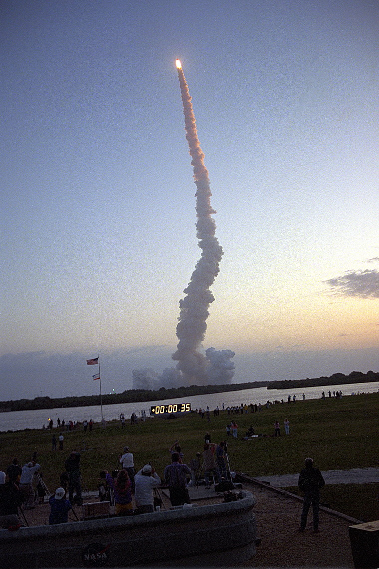
They gave it a try, but alas it was not to be, and the weather gods were just too strong on 8 April 1994. With the winds continuing to gust out of limits, Launch Director Bob Sieck ordered a scrub. Liftoff was rescheduled for 7:05 a.m. EDT on the 9th, and it was six anxious astronauts who climbed aboard Endeavour that morning, as another scrub would produce a conflict with other scheduled launches on the Eastern Range and effect a delay until at least the 23rd. Lying uncomfortably on their backs, they listened to the milestones over the intercom. By 6:56 am, as Endeavour emerged from the last scheduled “hold” in the countdown at T-9 minutes, they tightened their harnesses and steeled themselves for the controlled explosion that would soon come. At T-5 minutes, Kevin Chilton leaned over from the pilot’s seat and flipped a trio of switches to activate the orbiter’s Auxiliary Power Units (APUs). Endeavour now had hydraulic muscle.
In the acronym-laden minutes which followed, the astronauts were instructed to close and lock their helmet visors and activate the flow of oxygen into their suits. The Albuquerque-born Sid Gutierrez, the only shuttle pilot of Hispanic ancestry, led his team in their final “comm” checks and was wished “Vaya con Dios”—“Godspeed”—by launch controllers as a last send-off. With 31 seconds to go, they received the “Go” for autosequence start, as Endeavour’s computers assumed primary command of vehicle critical functions. Fifteen seconds later, navigational indicators on the instrument panel snapped smartly into their correct launch-ready positions. “Nav init,” confirmed Gutierrez.
At seven seconds, the swirling sparks of the hydrogen burn igniters gave way to a familiar rumble and sheet of translucent orange flame, as the three main engines roared to life, quickly reaching full power and producing three dancing Mach diamonds. “Three at a hundred!” yelled Chilton over the growing crescendo. Finally, at T-zero, the twin boosters flared plumes of brilliant orange flame and the STS-59 crew received a smart punch in the back as they departed Planet Earth on a mission to study Planet Earth.
The second part of this article will appear tomorrow.
Want to keep up-to-date with all things space? Be sure to “Like” AmericaSpace on Facebook and follow us on Twitter: @AmericaSpace