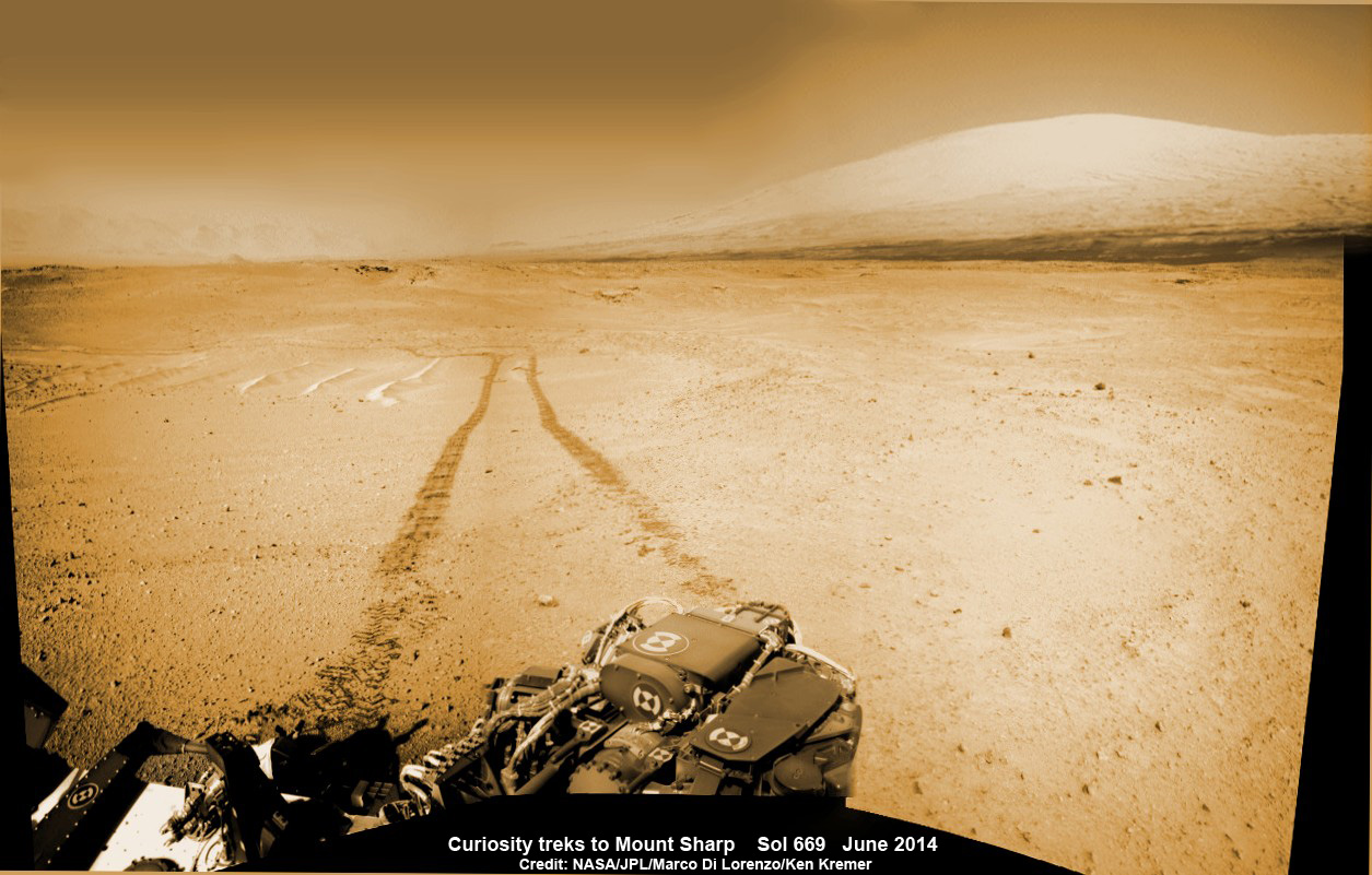
Curiosity treks to Mount Sharp in this photo mosaic view captured on Sol 669, June 24, 2014, the day the rover celebrated one Martian year since touchdown on the Red Planet. Navcam camera raw images stitched and colorized. Credit: NASA/JPL-Caltech/Marco Di Lorenzo/Ken Kremer – kenkremer.com
NASA’s intrepid rover Curiosity is celebrating a pair of milestone achievements in her epic trek across the floor of Gale Crater to reach the foothills of mysterious Mount Sharp on a quest to elucidate the history of Martian habitability.
On June 24, 2014 (Sol 669), Curiosity marked “1 Martian Year on Mars!” since her pulse pounding touchdown on the Red Planet nearly two Earth years ago on Aug. 5, 2012.
One Martian year is equivalent to 687 Earth days.
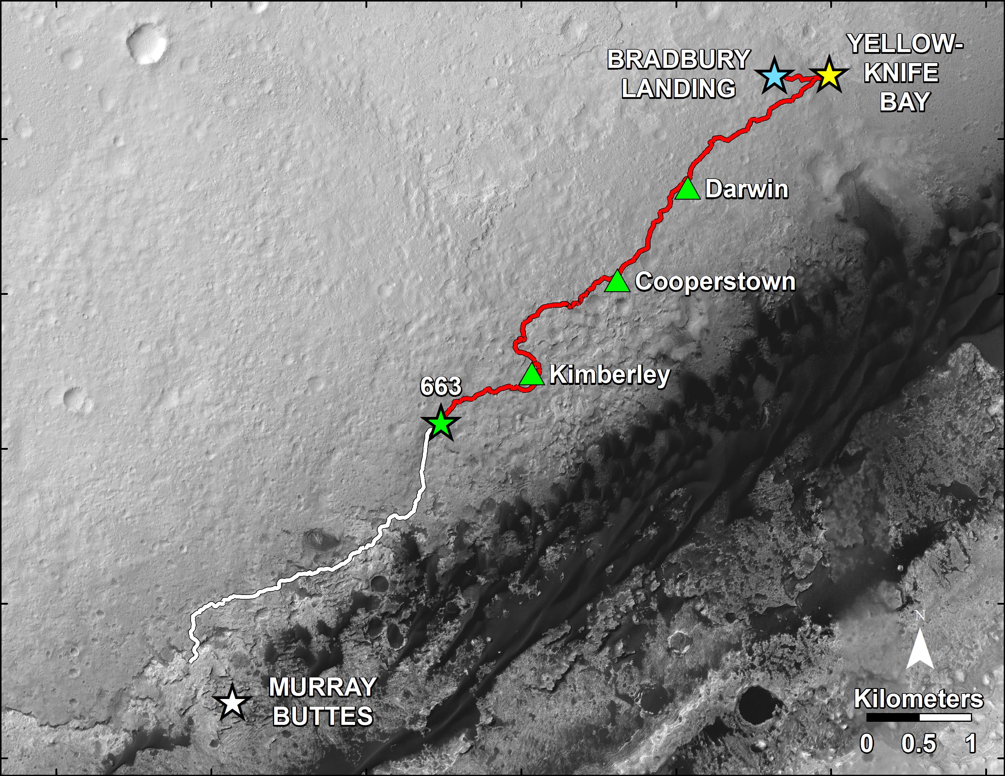
Then just three sols later, on June 27, 2014 (Sol 672), the one-ton robot drove outside her originally targeted landing ellipse.
“On yestersol’s drive [June 27], I left my landing ellipse—the 20×25 km area I targeted for landing,” Curiosity beamed back on her social media accounts.
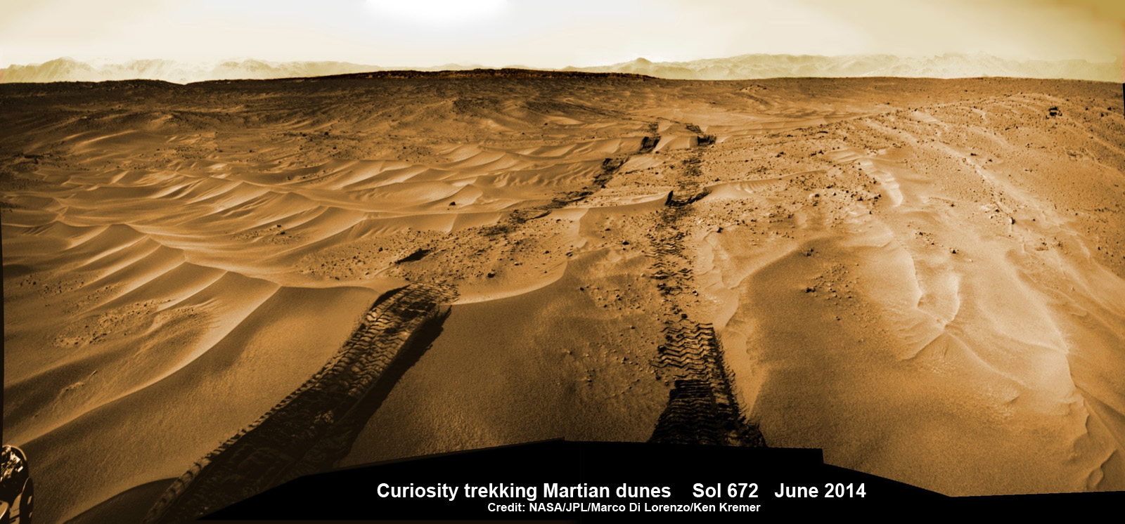
To get a good glimpse of Curiosity’s glorious views marking these major accomplishments along the road to Mount Sharp, check out our panoramic photo mosaics herein from Sols 669, 672, and more, created by the image processing team of Marco Di Lorenzo and Ken Kremer.
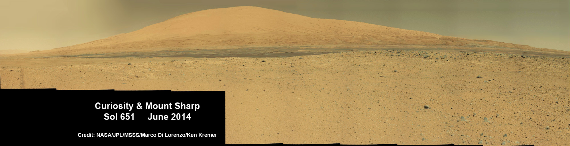
The six-wheeled rover has been commanded by her Earthly handlers to take the “rapid traverse timeline” across smooth dunes to drive as quickly as possible to the entry way to humongous Mount Sharp, which towers some 3.4 miles (5.5 km) into the Martian sky.
Mount Sharp is the robot’s ultimate destination inside Gale Crater because it holds caches of water-altered minerals. Such minerals could possibly indicate locations that sustained potential Martian life forms, past or present, if they ever existed.
“The vehicle was designed to be able to traverse far enough to drive out of the region defined by the uncertainty in the landing location, and has now achieved that laudable goal,” mission scientist Ken Herkenhoff confirmed.
“Coincidentally, the rover stopped right on the landing ellipse, a major mission milestone!”
The science and engineering team altered the rover’s Red Planet route a few months back to drive across smoother, less rocky terrain in order to minimize the then-accelerating buildup of wheel damaging rips and tears inflicted by interaction with sharp-edged rocks.
The rover teams mantra is “Drive, Drive, Drive” in order to arrive at Mount Sharp, perhaps by year’s end.
Occasionally the rover senses some slippage in the soft sand.
“After traversing 82 meters the rover stopped because it determined that it was slipping too much,” wrote Herkenhoff in an update on Sol 673, June 28.
So Herkenhoff reports that the rover team decided to conduct some “ripple driving tests.”
“The rover will drive across one of the nearby ripples and take a lot of Hazcam and Navcam images to see how the vehicle performs in the loose sand,” Herkenhoff reported today, July 8, Sol 683.
“Analysis of the data acquired during this ripple driving test will be useful in future traverse planning.”
During Year 1 on Mars, Curiosity accomplished her primary objective of discovering a habitable zone on the Red Planet that contains the chemical ingredients necessary to support microbial life in the ancient past.
Curiosity found the Martian habitable while exploring an ancient riverbed near her landing site, at an area known as Yellowknife Bay.
During 2013, Curiosity conducted the first two drill campaigns at the “John Klein” and “Cumberland” outcrop targets inside Yellowknife Bay. They were both mudstone rock outcrops, and the interiors were markedly different in color and much lighter compared to the new drill site at “Windjana” into a slab of red, sandstone rock.
This spring she bored a fresh hole into the “Windjana” rock outcrop on May 5, 2014, Sol 621, at the base of Mount Remarkable at a science stopping point called “The Kimberley Waypoint.”
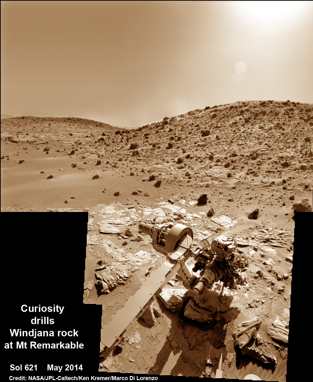
It was 0.63 inch (1.6 centimeters) in diameter and about 2.6 inches (6.5 centimeters) deep and resulted in a mound of dark grey colored drill tailings piled around.
Windjana lies some 2.5 miles (4 kilometers) southwest of Yellowknife Bay.
Curiosity has successfully delivered pulverized and sieved samples from all three drill sites to the pair of onboard miniaturized chemistry labs—the Chemistry and Mineralogy instrument (CheMin) and the Sample Analysis at Mars instrument (SAM)—for chemical and compositional analysis.
It was through the results of the SAM and CheMin analysis and the discovery of clay minerals that the science team was able to determine that this area on the floor of Gale Crater is a habitable zone.
“Windjana has more magnetite than previous samples we’ve analyzed,” said David Blake, principal investigator for Curiosity’s Chemistry and Mineralogy (CheMin) instrument at NASA’s Ames Research Center, Moffett Field, Calif., in a statement.
“A key question is whether this magnetite is a component of the original basalt or resulted from later processes, such as would happen in water-soaked basaltic sediments. The answer is important to our understanding of habitability and the nature of the early-Mars environment.”
Chemical analysis and further sample deliveries are in progress as NASA’s rover is “on the go” to simultaneously maximize movement and research activities.
The lower reaches of Mount Sharp are the rover’s ultimate goal because the sedimentary layers are believed to hold caches of water-altered minerals based on high resolution measurements obtained by the CRISM spectrometer aboard NASA’s powerful Mars Reconnaissance Orbiter (MRO), soaring overhead.
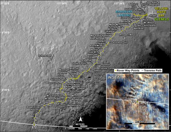
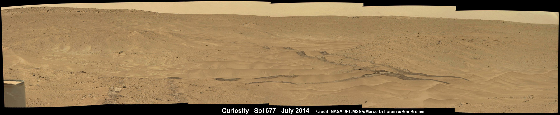
Curiosity still has about another 2.4 miles (3.9 kilometers) to go to reach the entry way at a gap in the dunes at the foothills of Mount Sharp sometime later this year.
So far Curiosity’s odometer totals over 5.1 miles (8.4 kilometers) since landing inside Gale Crater on Mars in August 2012. She has taken over 163,000 images.
Happy anniversary, Curiosity! Congratulations to the Curiosity team for a continuing outstanding job!