Curiosity Does ‘Walkabout’ in Search of Life’s Ingredients at Martian Mountain Base on Third Launch Anniversary

Curiosity rover panorama of Mount Sharp captured on June 6, 2014 (Sol 651) during traverse inside Gale Crater. Note rover wheel tracks at left. She will eventually ascend the mountain at the ‘Murray Buttes’ at right later this year. Assembled from Mastcam color camera raw images and stitched by Marco Di Lorenzo and Ken Kremer. Credit: NASA/JPL/MSSS/Marco Di Lorenzo/Ken Kremer-kenkremer.com
Curiosity rover panorama of Mount Sharp captured on June 6, 2014 (Sol 651), during traverse inside Gale Crater. Note rover wheel tracks at left. She will eventually ascend the mountain at the ‘Murray Buttes’ at right later this year. Assembled from Mastcam color camera raw images and stitched by Marco Di Lorenzo and Ken Kremer. Credit: NASA/JPL/MSSS/Marco Di Lorenzo/Ken Kremer-kenkremer.com

NASA’s Curiosity Mars Science Laboratory rover departed Earth three years ago today, blazing a spectacular path to the Red Planet atop a United Launch Alliance Atlas V rocket on Nov. 26, 2011, from Cape Canaveral Air Force Station, Fla.

She even took time to tweet holiday well-wishes to all her fans back home!

“3 years ago, I left Earth for Mars. Wishing you safe travels this #Thanksgiving, too!”

The one-ton rover embarked on a truly epic ongoing mission in search of life’s ingredients and habitats that could have sparked the creation and evolution of Martian microbes—and sustain their continued existence—if they ever formed upon the fourth rock from the Sun at some point over the past four billion years or so.

Curiosity’s science goals are rather similar in fact to those of another stupendous ongoing mission—the European Space Agency’s Rosetta orbiter and Philae comet lander duet now investigating the far flung comet 67P/Churyumov–Gerasimenko traveling way beyond Mars and 500 million kilometers (300 million miles) distant from Earth on another mission of cutting edge science to elucidate our origins.

Barely two weeks ago, on Nov. 12, the Philae comet lander discovered organic molecules—the building blocks of life—following a harrowing triple touchdown.

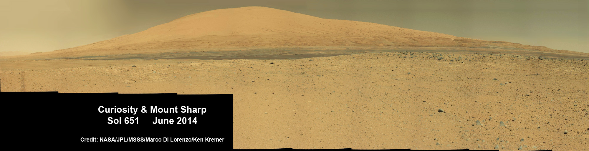
The six-wheeled Curiosity rover was targeted to land astride a humongous Martian mountain named Mount Sharp, towering 3.4 miles (5.5 kilometers) into the Martian sky inside Gale Crater.

Following a nine-month-long interplanetary journey, Curiosity hit the Martian atmosphere at about 13,000 mph and survived the “Seven Minutes of Terror” and scorching temperatures while plummeting through the atmosphere.

Then came the nailbiting and unprecedented rocket-assisted sky crane maneuver during the final stages of the descent, leading to her death defying touchdown on the Red Planet a little over two years ago, on Aug. 6, 2012, inside Gale Crater.

This view shows the path and some key places in a survey of the "Pahrump Hills" outcrop by NASA's Curiosity Mars rover in autumn of 2014. The outcrop is at the base of Mount Sharp within Gale Crater. Credit: NASA/JPL-Caltech/MSSS
This view shows the path and some key places in a survey of the “Pahrump Hills” outcrop by NASA’s Curiosity Mars rover in autumn of 2014. The outcrop is at the base of Mount Sharp within Gale Crater. Credit: NASA/JPL-Caltech/MSSS

The mammoth, layered mountain stands taller than America’s Mount Rainier and dominates most of the Gale Crater landing site and is Curiosity’s primary destination of the mission.

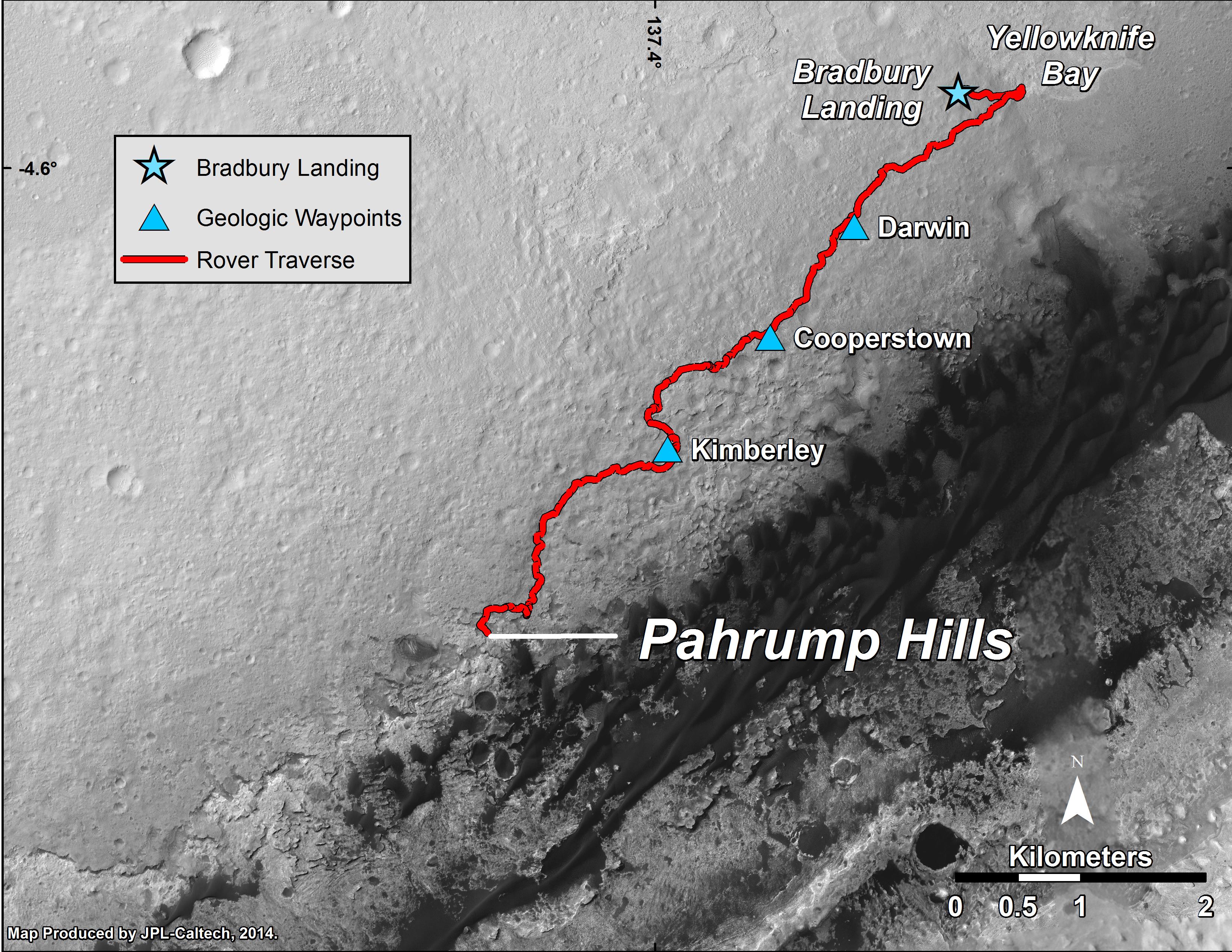
Since her safe touchdown at Bradbury Landing, Curiosity has been on an epic trek of more than 5 miles (8 kilometers) miles across the crater floor, while making a multi-month detour in early 2013 to a scientifically interesting region called “Yellowknife Bay.”

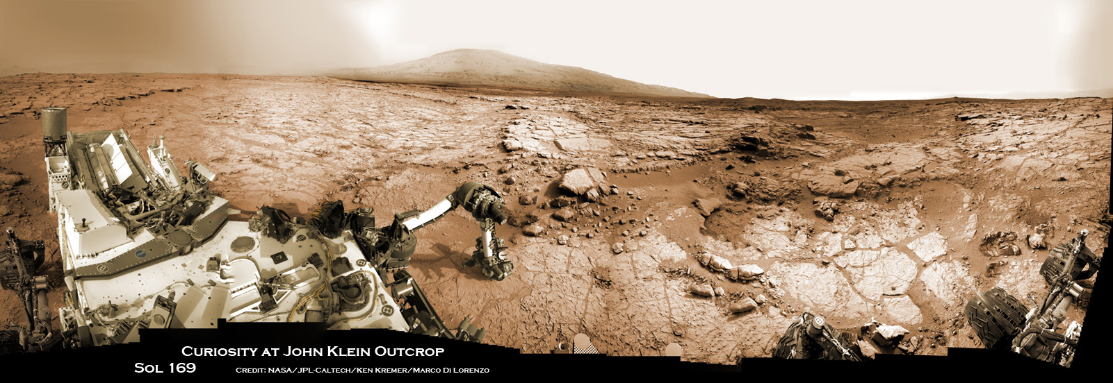
The gamble paid off handsomely, when an analysis of history’s first-ever interplanetary drill samples at the “John Klein” outcrop revealed the presence of the phyllosilicate minerals, the chemical ingredients necessary to sustain life, which is indicative of a habitable zone on Mars.

Curiosity accomplished Historic 1st drilling into Martian rock at John Klein outcrop on Feb 8, 2013 (Sol 182) and discovered a habitable zone, shown in this context mosaic view of the Yellowknife Bay basin taken on Jan. 26 (Sol 169). The robotic arm is pressing down on the surface at John Klein outcrop of veined hydrated minerals – dramatically back dropped with her ultimate destination; Mount Sharp. Credit: NASA/JPL-Caltech/Ken Kremer-kenkremer.com/Marco Di Lorenzo
Curiosity accomplished historic first drilling into Martian rock at John Klein outcrop on Feb 8, 2013 (Sol 182), and discovered a habitable zone, shown in this context mosaic view of the Yellowknife Bay basin taken on Jan. 26 (Sol 169). The robotic arm is pressing down on the surface at John Klein outcrop of veined hydrated minerals–dramatically back dropped with her ultimate destination; Mount Sharp. Credit: NASA/JPL-Caltech/Ken Kremer-kenkremer.com/Marco Di Lorenzo

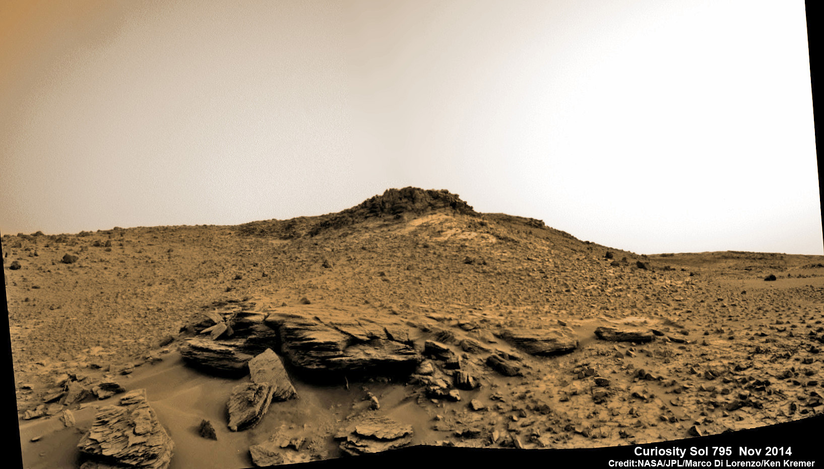
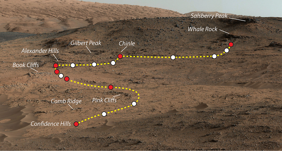
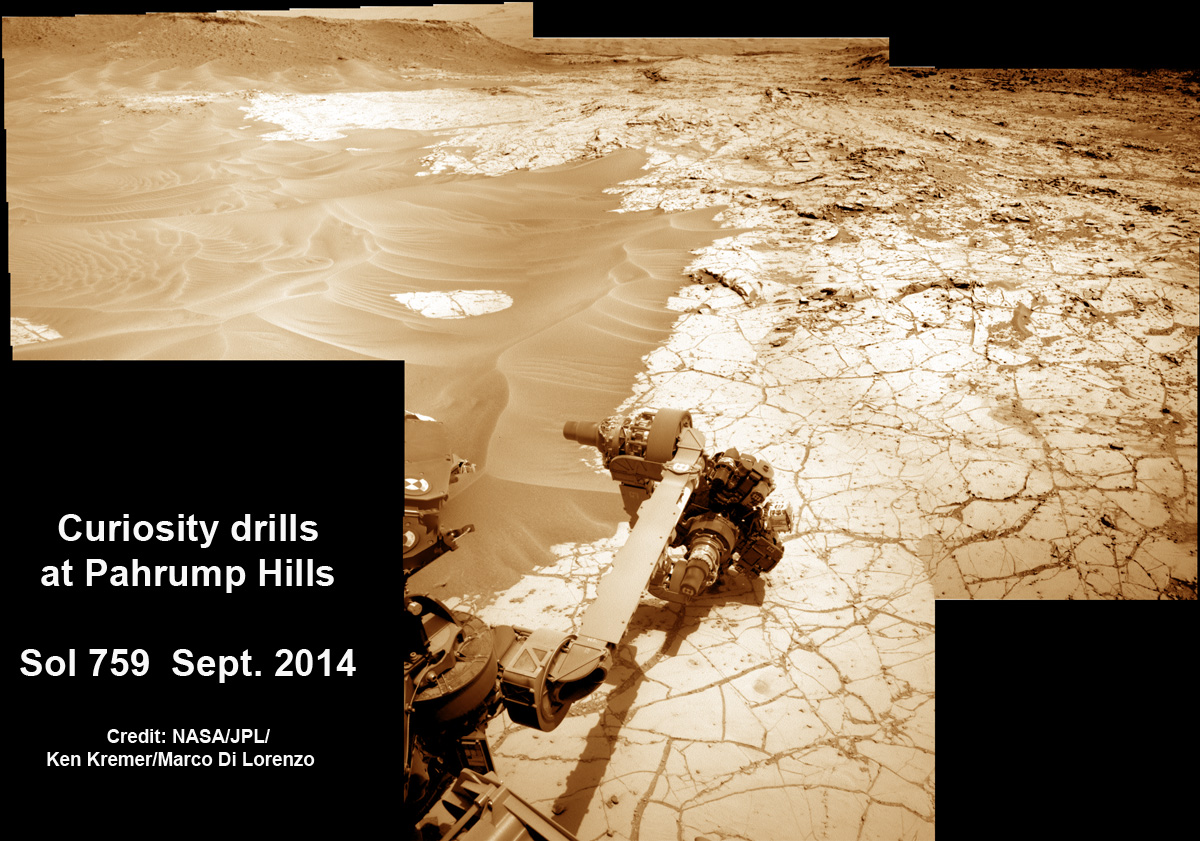
Today, Curiosity has reached the foothills of Mount Sharp in a region dubbed the “Pahrump Hills” and has spent this Fall conducting what’s known to geologists as a “walkabout.”

She’s on a reconnaissance mission to locate targets of scientific interest to investigate in the coming weeks and months.

But before the big walkabout, the rover first collected a drill sample from a target called “Confidence Hills” within the outcrop area to better assess the science potential.

NASA’s Curiosity rover conducts 4th drill campaign at ‘Pahrump Hills’ rock outcrop on Sol 759, Sept. 24, 2014, at the foothills of Mount Sharp seen in the distance.  Navcam camera raw images stitched and colorized.   Credit: NASA/JPL-Caltech/Ken Kremer-kenkremer.com/Marco Di Lorenzo
NASA’s Curiosity rover conducts fourth drill campaign at “Pahrump Hills” rock outcrop on Sol 759, Sept. 24, 2014, at the foothills of Mount Sharp seen in the distance. Navcam camera raw images stitched and colorized. Credit: NASA/JPL-Caltech/Ken Kremer-kenkremer.com/Marco Di Lorenzo

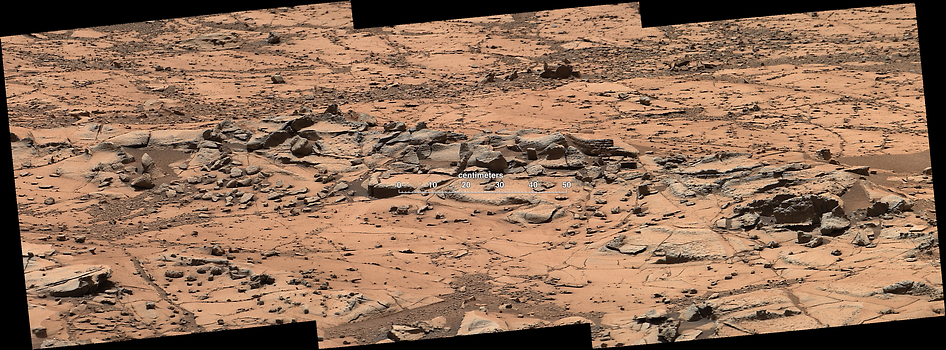
Now the rover has begun a second pass to carefully inspect selected rocks in the outcrop in more detail.

In its first pass up this outcrop, Curiosity drove about 360 feet (110 meters) and scouted sites ranging about 30 feet (9 meters) in elevation. It evaluated potential study targets from a distance with mast-mounted cameras and a laser-firing spectrometer, according to NASA.

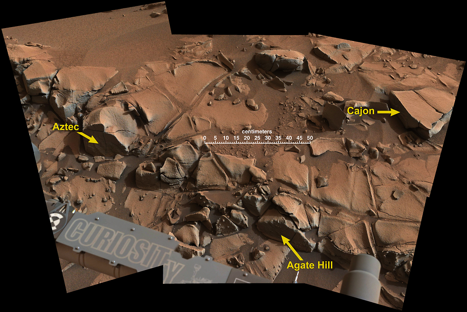
“We see a diversity of textures in this outcrop — some parts finely layered and fine-grained, others more blocky with erosion-resistant ledges,” said Curiosity Deputy Project Scientist Ashwin Vasavada of NASA’s Jet Propulsion Laboratory, Pasadena, Calif., in a statement.

“Overlaid on that structure are compositional variations. Some of those variations were detected with our spectrometer. Others show themselves as apparent differences in cementation or as mineral veins. There’s a lot to study here.”

The rover is using all the instruments at its disposal during her second trip around the outcrop to assess the best targets for further up-close scrutiny and as potential candidates for drilling and onboard sample analysis during a third go round of the outcrop.

This small ridge, about 3 feet long, appears to resist wind erosion more than the flatter plates around it. Such differences are among the traits NASA's Curiosity Mars rover is examining at selected rock targets at the base of Mount Sharp. Curiosity's Mastcam acquired this view on Oct. 7, 2014.  Credit: NASA/JPL-Caltech/MSSS
This small ridge, about 3 feet long, appears to resist wind erosion more than the flatter plates around it. Such differences are among the traits NASA’s Curiosity Mars rover is examining at selected rock targets at the base of Mount Sharp. Curiosity’s Mastcam acquired this view on Oct. 7, 2014. Credit: NASA/JPL-Caltech/MSSS

“The variations we’ve seen so far tell us that the environment was changing over time, both as the sediments were laid down and also after they hardened into bedrock,” Vasavada said.

“We have selected targets that we think give us the best chance of answering questions about how the sediments were deposited — in standing water? flowing water? sand blowing in the wind? — and about the composition during deposition and later changes.”

So far Curiosity’s odometer totals over 5.5 miles (9.0 kilometers) since landing inside Gale Crater on Mars in August 2012.

She has taken some 203,000 images during over 820 Sols of exploration.

This view from the Mast Camera (Mastcam) on NASA's Curiosity Mars rover shows a swath of bedrock called "Alexander Hills," which the rover approached for close-up inspection of selected targets.   Credit: NASA/JPL-Caltech/MSSS
This view from the Mast Camera (Mastcam) on NASA’s Curiosity Mars rover shows a swath of bedrock called “Alexander Hills,” which the rover approached for close-up inspection of selected targets. Credit: NASA/JPL-Caltech/MSSS

Stay tuned here for continuing updates.

Ken Kremer


Want to keep up-to-date with all things space? Be sure to “Like” AmericaSpace on Facebook and follow us on Twitter: @AmericaSpace

NASA’s Curiosity rover scans around the Pahrump Hills outcrop at the base of Mount Sharp in this photo mosaic stitched from raw images taken on Sol 795, October 31, 2014.    Credit: NASA/JPL/Marco Di Lorenzo/Ken Kremer-kenkremer.com
NASA’s Curiosity rover scans around the Pahrump Hills outcrop at the base of Mount Sharp in this photo mosaic stitched from raw images taken on Sol 795, October 31, 2014. Credit: NASA/JPL/Marco Di Lorenzo/Ken Kremer-kenkremer.com
This map shows the route driven by NASA's Curiosity Mars rover from the "Bradbury Landing" location where it landed in August 2012 to the "Pahrump Hills" outcrop where it drilled into the lowest part of Mount Sharp.  Credit: NASA/JPL-Caltech/Univ. of Arizona
This map shows the route driven by NASA’s Curiosity Mars rover from the “Bradbury Landing” location where it landed in August 2012 to the “Pahrump Hills” outcrop where it drilled into the lowest part of Mount Sharp. Credit: NASA/JPL-Caltech/Univ. of Arizona

Rosetta Team Homing In on Philae’s Historic Final Comet Touchdown Site and Organics Location

Expedition 42 Crew to Celebrate Thanksgiving in Orbit