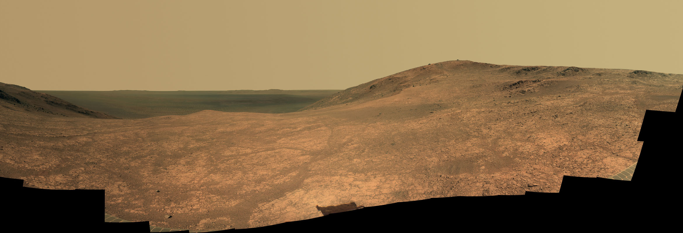
Water on Mars is one of the most talked about and controversial subjects in planetary science. It is now well-known that Mars used to be a much wetter place than it is now, although just how much water there was, and how long it lasted, is still a matter of considerable debate. Direct evidence from rovers, landers, and orbiters, including observations of ancient riverbeds, gullies, and lakes, has shown how at one time Mars was much more Earth-like than it is today. Rovers like Curiosity, Opportunity, and Spirit have actually driven over long-dried-up lakebeds, salty playa lakes, and regions of ancient geothermal activity such as hot steam vents. Now, the Opportunity rover is going to visit another feature not yet explored by any other rover or lander: a gully thought to have been carved by water millions or billions of years ago.
The gully cuts from west to east through the rim of Endeavour Crater, where the rover has been exploring for several years now, and is about as long as two football fields. It is currently about half a mile from the rover, which is making its way along the rim a bit farther north. Scientists think this gully was carved by water (although a long time ago), similar to other gullies and old riverbeds seen in many locations on Mars.
“We are confident this is a fluid-carved gully, and that water was involved,” said Opportunity Principal Investigator Steve Squyres of Cornell University, Ithaca, N.Y. “Fluid-carved gullies on Mars have been seen from orbit since the 1970s, but none had been examined up close on the surface before. One of the three main objectives of our new mission extension is to investigate this gully. We hope to learn whether the fluid was a debris flow, with lots of rubble lubricated by water, or a flow with mostly water and less other material.”
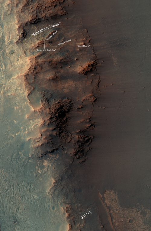
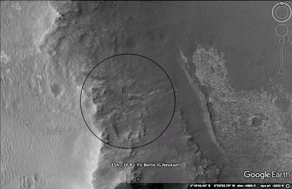
A gully like this has never been seen up close before—only by spacecraft in orbit—so it will be an exciting “first look” for the rover team. Opportunity will drive down the entire length of the gully, onto the crater floor below. This is part of a two-year extended mission for the rover, which began Oct. 1. Opportunity’s prime mission ended in April 2004, and has been extended multiple times since then.
“We have now exceeded the prime-mission duration by a factor of 50,” said Opportunity Project Manager John Callas of NASA’s Jet Propulsion Laboratory, Pasadena, Calif. “Milestones like this are reminders of the historic achievements made possible by the dedicated people entrusted to build and operate this national asset for exploring Mars.”
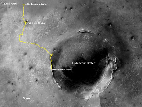
Opportunity has been on the western rim of Endeavour Crater for a long time now, after first reaching it in 2011, gradually making its way southward. It has approached the crater bottom before, but has never gone fully in. Endeavour Crater is huge, at 14 miles (22 kilometers) in diameter.
So what does the mission team expect or hope to find in the gully?
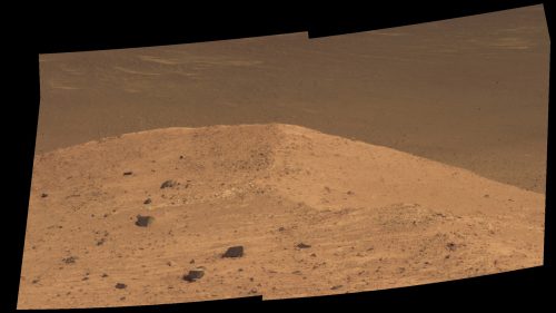
“We may find that the sulfate-rich rocks we’ve seen outside the crater are not the same inside,” Squyres said. “We believe these sulfate-rich rocks formed from a water-related process, and water flows downhill. The watery environment deep inside the crater may have been different from outside on the plain – maybe different timing, maybe different chemistry.”
As of right now, the rover is at a rock outcrop overlooking the crater floor called Spirit Mound, just outside of Marathon Valley and near the east end of Bitterroot Valley. Last month, the rover drove through the Lewis and Clark Gap, a shallow point in the wall separating Marathon Valley from Bitterroot Valley.
Recently, the rover had been busy examining rocks in Marathon Valley, another geologic cut through the crater rim, but it is a valley, not a gully or riverbed. It does, however, contain clay minerals, which are also evidence for past water in the region, perhaps groundwater. That water would also have been less acidic or salty than in other regions of Meridiani Planum away from Endeavour Crater, where Opportunity landed in 2004.
Upon closer examination, the clays were found to be present in reddish streaks, and the material was very weathered and crumbly. While the newer Curiosity rover has a drill to penetrate several centimeters into rocks, Opportunity has the RAT, which can grind into just the surface layers of rocks.
“What we usually do to investigate material that’s captured our interest is find a bedrock exposure of it and use the RAT,” Squyres said. “What we didn’t realize until we took a close-enough look is that this stuff has been so pervasively altered, it’s not bedrock. There’s no solid bedrock you could grind with the RAT.”
“Fractures running through the bedrock, forming conduits through which water could flow and transport soluble materials, could alter the rock and create the pattern of red zones that we see,” Squyres also noted.
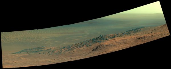
On the southern edge of Marathon Valley, Opportunity had also climbed a steep slope called Knudsen Ridge. Knudsen Ridge is a great look-out point, overlooking the vast floor of Endeavour Crater. It was named after Danish astrophysicist and planetary scientist Jens Martin Knudsen (1930-2005), who was a founding member of the science team for both Opportunity and its twin rover Spirit. The rover handled the terrain well.
“Opportunity showed us how sure-footed she still is,” said Callas. “The wheel slip has been much less than we expected on such steep slopes.”
Before that, the rover climbed to the top of Cape Tribulation on the same side of Endeavour Crater, which is 4,560 feet (1,390 meters) tall, the highest point on the rim of the crater. The view from this vantage point was spectacular.
Opportunity also found high levels of sulfur in a wheel scuff made by the rover in the surface material.
“In the scuff, we found one of the highest sulfur contents that’s been seen anywhere on Mars. There’s strong evidence that, among other things, these altered zones have a lot of magnesium sulfate. We don’t think these altered zones are where the clay is, but magnesium sulfate is something you would expect to find precipitating from water,” Squyres added. “Fractures running through the bedrock, forming conduits through which water could flow and transport soluble materials, could alter the rock and create the pattern of red zones that we see.”
Opportunity also saw a large dust devil not too long ago, which is a rare occurrence. Its twin rover, Spirit, however, saw many of them in Gusev Crater before it stopped functioning in 2009.
The longevity of this mission has been incredible. When the rover first landed in 2004, it was hoped to last three months. Now it is late 2016 and the mission is still going strong! Opportunity has survived seven Martian winters so far, and in 2017 will face its eighth.
“Twelve years is a very long time to have this sort of a continuous presence,” said Matt Golombek, Mars rovers project scientist. “For a science team to be this involved, on a daily basis, for this long on Mars, is pretty much unprecedented.”
More information about the Opportunity mission, as well as its now-defunct twin rover Spirit, is available here.
Want to keep up-to-date with all things space? Be sure to “Like” AmericaSpace on Facebook and follow us on Twitter: @AmericaSpace


“One of the three main objectives of our new mission extension is to investigate this gully.”
What are the other two?