This morning, 126 miles off the coast of Daytona Beach, Fla., Orbital ATK’s modified L-1011 aircraft, nicknamed Stargazer, successfully deployed their air-launched Pegasus XL rocket with a fleet of eight microsatellites to low-Earth orbit for NASA’s Cyclone Global Navigation Satellite System (CYGNSS) mission. Departing the “Skid Strip” runway at Cape Canaveral Air Force Station, the world’s only still operational L-1011 flew to the drop zone and deployed the three-stage Pegasus, the world’s first commercial rocket, from 39,000 feet at 8:37 a.m. EST.
Payload deployment occurred at 8:52 a.m. EST.
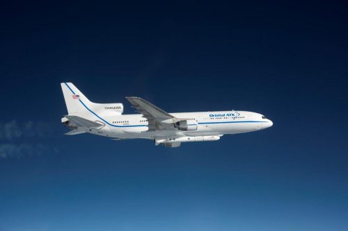
“I am proud of the entire professional team on the Space Coast who worked together flawlessly to make our twenty-second major launch operation of the year a success,” said Brig. Gen. Wayne Monteith, 45th Space Wing commander and mission Launch Decision Authority. “It’s been 13 years since we last supported a Pegasus launch and our collective team for this unique mission didn’t miss a beat.”
A first launch attempt Dec. 12 was called off when an issue with flight parameter data used by spacecraft software was discovered, preventing the launch vehicle release system from a safe Pegasus deployment.
Pre-flight checks of the airplane Dec. 12 showed no indications of an issue; the hydraulic system responsible for releasing the Pegasus functioned properly.
A replacement L-1011 component was flown in from Mojave, Ca., and installed, and new flight parameter data underwent verification testing on an engineering model before being uploaded to the spacecraft on Wed., Dec. 14.
Once released from Stargazer’s belly the Pegasus was in free-fall for five seconds before igniting its first stage rocket motor, aiming CYGNSS for a 35 degree low-Earth orbit so the constellation can survey the mid latitudes where most cyclones form.
Piloting the two-seat F/A-18B Hornet chase plane was NASA Armstrong Flight Research Center test pilot Troy Asher. NASA videographer Lori Losey captured imagery and provided live NASA TV coverage from the backseat.
The constellation of small weather satellites are all identical, developed by the University of Michigan College of Engineering to probe the inner core of hurricanes and learn more about their rapid intensification. Current remote sensors simply cannot see through the heavy rain in the inner core of a powerful hurricane, and so they cannot observe changes in the storm over short periods of time either.
The satellites will team up with the Global Positioning System (GPS) constellation to help remedy this problem and to measure wind speeds over Earth’s oceans and air-sea interactions to help scientists and meteorologists better understand and predict the path of a hurricane.
For the first time, scientists will be able to probe key air-sea interaction processes that take place near the inner core of these monster storms, which are rapidly changing and play large roles in the genesis and intensification of hurricanes.
VIDEO: 43rd Pegasus rocket air launches NASA’s CYGNSS mission
“We are proud to provide another successful Pegasus launch for our NASA customer,” said Rich Straka, Vice President and General Manager of Orbital ATK’s Launch Vehicles Division. “Congratulations to the NASA CYGNSS and Orbital ATK teams on another great mission.”
The Space Physics Research Laboratory at the University of Michigan College of Engineering in Ann Arbor leads overall mission execution, in partnership with the Southwest Research Institute in San Antonio, Texas. The Climate and Space Sciences and Engineering Department at the University of Michigan leads the science investigation, and the Earth Science Division of NASA’s Science Mission Directorate oversees the mission.
Pegasus launch 44 will come as soon as next summer, with NASA’s Ionospheric Connection Explorer (ICON) mission. Led by the University of California, Berkeley, with oversight by the Explorers Program at NASA’s Goddard Space Flight Center in Greenbelt, Md., the two-year mission will launch from the Reagan Test Site on Kwajalein Atoll (in the Republic of the Marshall Islands) to explore the boundary between Earth and space (the ionosphere) and help scientists better understand the physical connection between Earth and the immediate space environment around it.
.
Be sure to “LIKE” AmericaSpace on Facebook and follow us on Instagram & Twitter!
.
