Much of the talk of Mars these days centers on two missions: one in the here-and-now and another at least two decades into the future. Last August, NASA’s Curiosity rover touched down in the broad expanse of Gale Crater and has already made significant inroads in our understanding of the Red Planet. As for the other voyage, much excitement surrounds plans to send humans to Mars, with newly-reinaugurated President Barack Obama timetabling such an event for the mid-2030s at the earliest. Yet another important mission has been working earnestly to further our knowledge of the planet which is closest to our own in many fundamental ways.
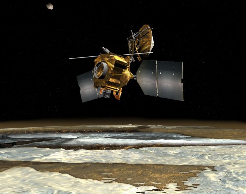
Since its arrival in orbit in March 2006, the Mars Reconnaissance Orbiter (MRO, nicknamed ‘Mr. O’) has yielded its own valuable insights. This week, NASA announced the possible presence of subsurface water within McLaughlin Crater, a yawning bowl 57 miles in diameter and up to 1.4 miles deep, at some point in Mars’ geological past. The crater lies on a slope along the edge of “Arabia Terra,” a battered and eroded region in Mars’ northern hemisphere, which is thought to represent one of the planet’s oldest terrains. The discovery adds to a growing dossier of evidence that Mars may have been considerably “wetter” in its early evolution.
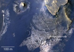
According to data from MRO’s Compact Reconnaissance Imaging Spectrometer for Mars (CRISM), the crater contains layered, flat rocks at its floor, which contain carbonate and clay minerals, known to form in the presence of water. McLaughlin lacks “inflow” channels of any large size, and small channels within its walls end close to a level which could have marked the surface of an ancient lake, contained within the crater’s closed basin. The underground zone contributing the water supply has been seen by some scientists as a wet oasis, possibly capable of providing a life-sustaining habitat.
“Taken together, the observations in McLaughlin Crater provide the best evidence of carbonate forming within a lake environment, instead of being washed into a crater from outside,” said Joseph Michalski, jointly affiliated with the Planetary Science Institute in Tucson, Ariz., and London’s Natural History Museum. He added that several other CRISM studies have enabled scientists to study rocks exhumed from Mars’ subsurface by meteoritic impacts … rocks which had been “altered” early in the planet’s history, probably by the action of hydrothermal fluids. “These fluids, trapped in the subsurface,” explained Michalski, “could have periodically breached the surface in deep basins such as McLaughlin Crater, possibly carrying clues to surface habitability.”
CRISM was designed, built, and tested at the Johns Hopkins Applied Physics Laboratory in Baltimore, Md., with the specific purpose of searching for mineralogical traces of past and present water deposits on Mars. It represents the work of investigators from over ten different universities and academic institutions, and its search has seen it put to work on mapping the presence of iron and oxides—which can be chemically altered by water—as well as phyllosilicates and carbonates, known to form in the presence of water. CRISM has also proven important in examining ice and dust particles in the Martian atmosphere as a means of understanding the mechanisms behind climatic and seasonal change.
Launched in August 2005, atop an Atlas V “401” rocket—the very same configuration as will be used to loft the TDRS-K communications and data-relay satellite next week—the $720 million MRO mission arrived in orbit around the Red Planet just seven months later. Following a prolonged phase of atmospheric “aerobraking,” it began its first science phase the following November and its purpose has been described as two-pronged: “Reconnaissance” of sites for future landing missions (including that of Curiosity) and “Exploration” of the planet’s climate, weather, atmosphere, and geological history.
As well as monitoring Mars’ weather and surface conditions on a daily basis, MRO photographed the Opportunity rover on the rim of Victoria Crater in October 2006 and the descent of Curiosity towards Bradbury Landing last August. It also photographed the parachute-assisted fall of the Phoenix lander toward a touchdown in the vast lowland region of Vastitas Borealis in May 2008. Future plans for MRO continue beyond its retirement from formal science duties. Shortly after its arrival in orbit around Mars, in November 2006, it successfully demonstrated its ability as a communications and data relay for the Spirit rover. This has led to much anticipation that it will support the communications and navigational needs of upcoming missions.
Current thinking postulates that McLaughlin’s depth provided the scope for the underground water to flow into the interior of the crater. The results of Michalski’s team will be published on Saturday in the online version of Nature Geoscience. “This new report and others are continuing to reveal a more complex Mars than previously appreciated,” said MRO Project Scientist Rich Zurek of NASA’s Jet Propulsion Laboratory in Pasadena, Calif., “with at least some areas more likely to reveal signs of ancient life than others.”
The McLaughlin Crater should be a primary target for the next rover mission.