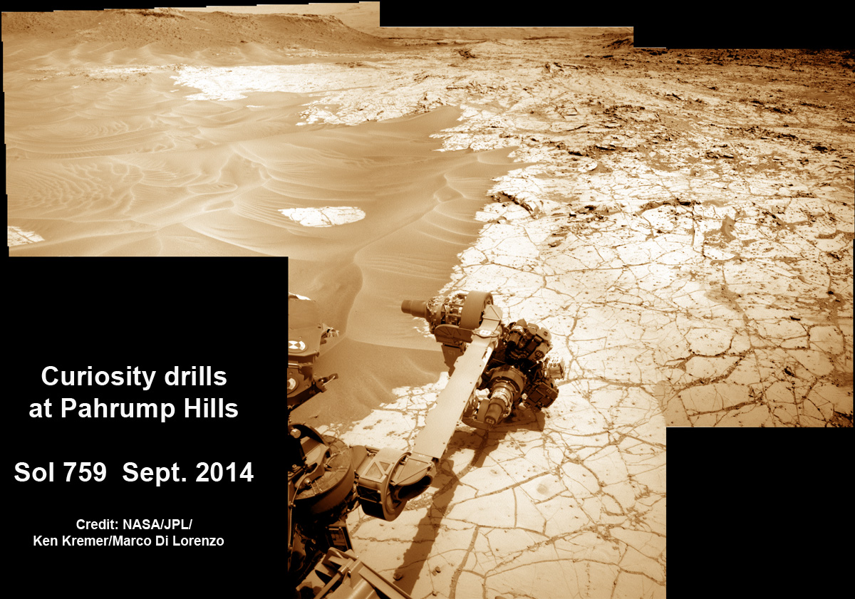
See drill site photomosaics below
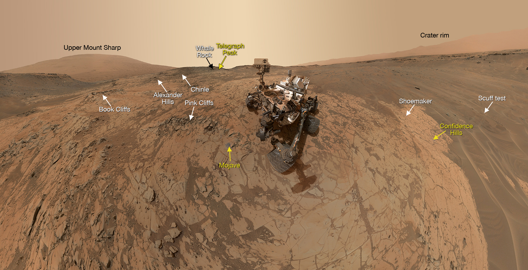
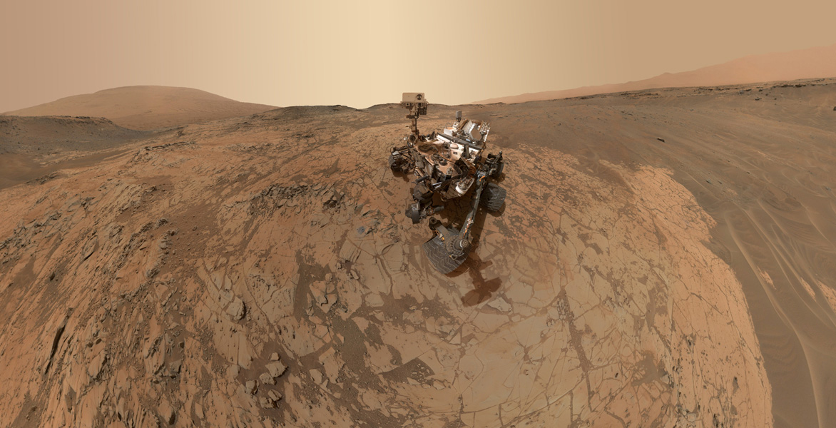
The car-sized Curiosity rover has snapped a sweeping selfie encompassing the spectacular alien terrain of the Red Planet, where she has spent the past five months wandering, exploring, and working to unravel the mysteries of the planet’s past and assess ancient habitable environments.
This latest selfie from Curiosity was just released by NASA on Feb. 24 and taken during the last half of January at the majestic “Pahrump Hills” outcrop area on Mars. It shows a super wide-angle view around the “Mojave” site where she just conducted a second local area drilling operation for sample analysis by the rover’s duo of on-board chemistry laboratories.
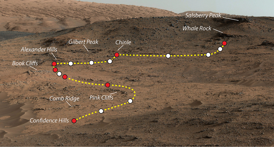
The annotated mosaic scene above shows the locations of both the “Pahrump Hills” drill site campaigns completed so far and a third one upcoming very soon. See below our exclusive photo mosaics showing the rover’s deployed arm in action boring into Mars at those two drill sites.
The self-portrait was assembled from dozens and dozens of images taken by the Mars Hand Lens Imager (MAHLI) camera located on the end of the rover’s 7-foot-long (2.1-meter-long) robotic arm during January 2015. Therefore, the arm can’t be included in the mosaic, just like when you are taking a hand-held selfie of yourself.
Prior to Mojave, Curiosity also snapped selfies at the “Rocknest,” “John Klein,” and “Windjana” sample-collection sites.
“Mojave 2” is the name of the rock target at the “Mojave” site where the vehicle took its second “bite” out of the base layer of the Martian mountain she is currently investigating and found that the Martian material has been altered by water that’s a different flavor and more acidic than the first “bite.”
The wide-field view gives a distinctly enhanced context of the current work location because it also includes the nearby site where Curiosity took that first “bite” out of “Pahrump Hills” at the “Confidence Hills” target during September 2014, as well as where she will take her third “bite” shortly at “Telegraph Peak.”
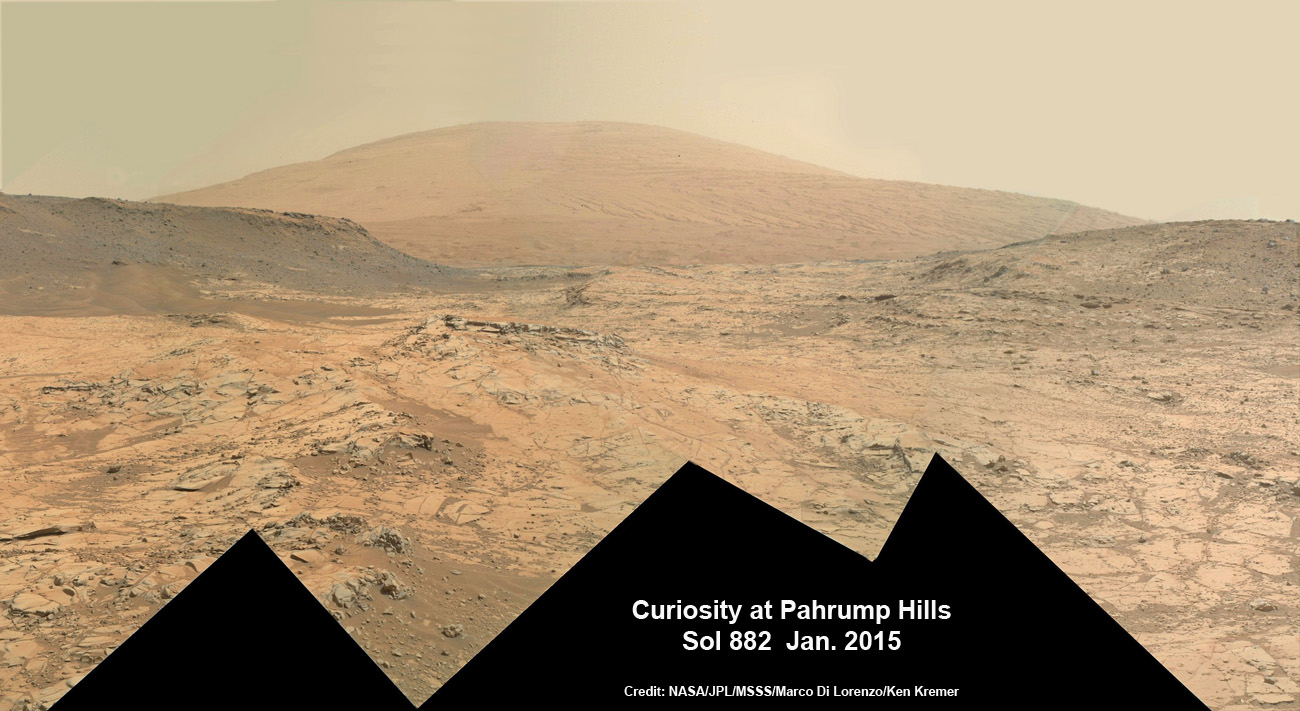
The “Pahrump Hills” outcrop belongs to the bedrock exposure of the Murray formation that forms the basal geological layer at the base of Mount Sharp, at the center of Mars’ Gale Crater.
The scene is beautifully backdropped by the upper portion of Mount Sharp and the eroded rim of Gale Crater.
Mount Sharp is comprised of sedimentary rock layers that record the history of ancient Martian environments and is the primary destination of the mission.
The mountain towers 3.4 miles (5.5 kilometers) into the Martian sky and dominates the center of the Gale Crater, where Curiosity safely touched down some 30 months ago in August 2012.
“Compared with the earlier Curiosity selfies, we added extra frames for this one so we could see the rover in the context of the full Pahrump Hills campaign,” said rover team member Kathryn Stack at NASA’s Jet Propulsion Laboratory, Pasadena, Calif.
“From the Mojave site, we could include every stop we’ve made during the campaign.”
Most of the frames in the new mosaic were taken Jan. 14, 2015, during Sol 868. Additional frames of the Martian terrain were taken Jan. 29, 2015, during Sol 882, to expand the selfie scene on the left and right into a wider, more expansive panorama. Finally, the frames showing the “Mojave ” drill holes were taken Jan. 31, 2015, during Sol 884.
Curiosity has been surveying the “Pahrump Hills” area around the base of Mount Sharp for over five months since arriving there last fall in search of scientifically interesting candidates for drilling to elucidate the history of habitability on Mars.
The first “bite” taken from the mountain base was at a nearby target called “Confidence Hills” during September 2014.
The rover then conducted a “walkabout” to scout the area for the best places to drill. During the walkabout, the rover climbed from the outcrop’s base to higher sections three times to create vertical profiles of the rock structures and chemistry for determining the most scientifically productive spots for sample-collection drilling.
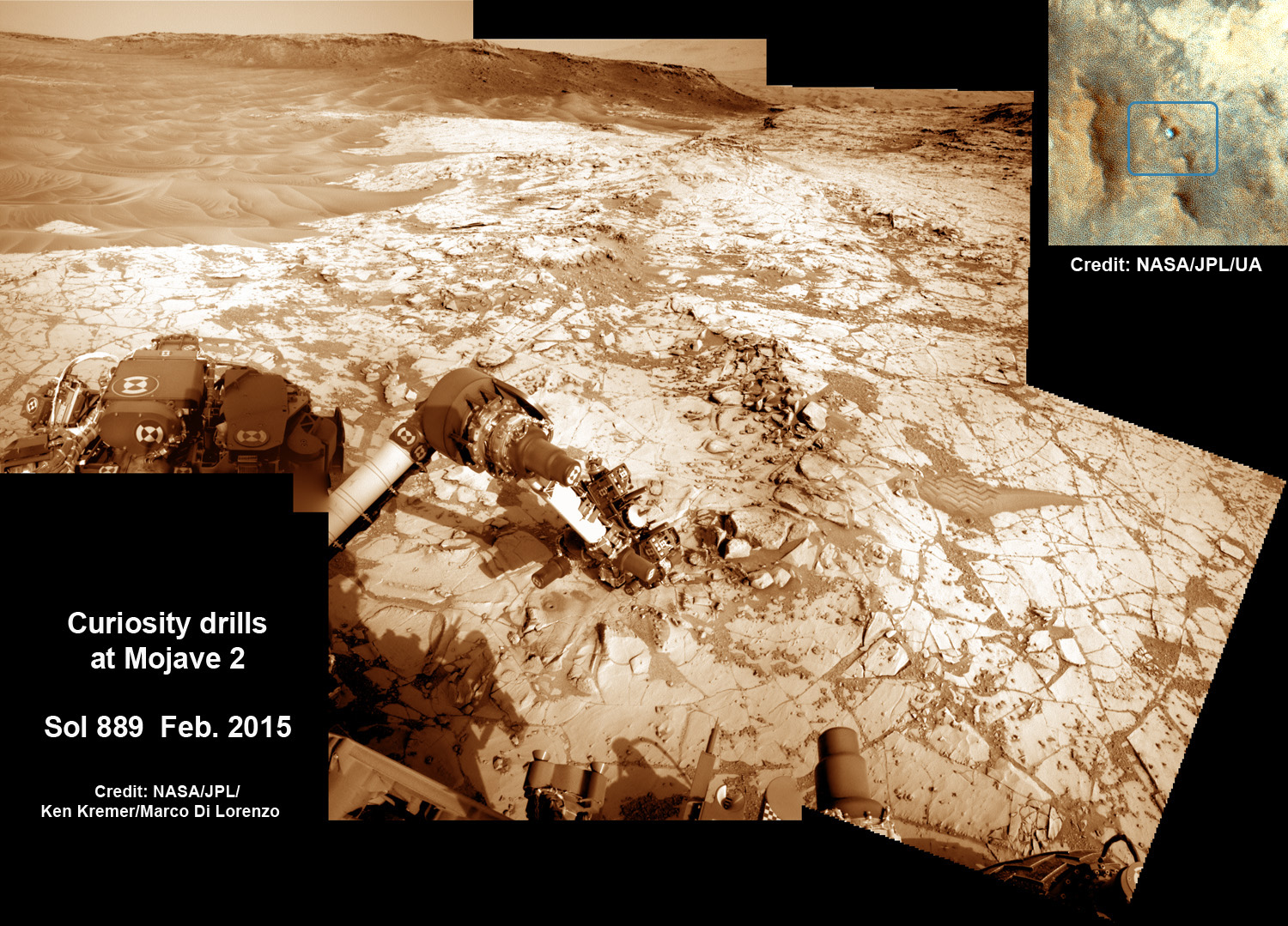
The second bite was carried out at a crystal-rich rock target named “Mojave 2” that lies in the “Pink Cliffs” portion of a outcrop called “Pahrump Hills,” an exposure of the Murray formation that is the basal geological unit of Mount Sharp. The location is shown in another annotated scene below.
Curiosity bored the “Mojave 2” sample-collection hole on Sol 882 (Jan. 29) to a full depth of about 2.6 inches (6.5 centimeters). The rotary-percussive drill successfully cut a hole about 0.63 inch (1.6 centimeters) in diameter.
The rover always drills an initial mini-drill test hole to determine if the chosen rock target is indeed safe and suitable for full-depth sample collection drilling.
Therefore, two holes are visible in the new selfie as well as a post-drilling dump pile of leftover material not fed into the pair of on-board miniaturized chemistry labs in the rovers belly: CheMin and SAM.
An up-close view of both drill sites at “Confidence Hills” and “Mojave 2” is also shown in the navcam panoramas created by the imaging team of Ken Kremer and Marco Di Lorenzo.
So far Curiosity’s odometer totals over 6.4 miles (10.3 kilometers) since landing inside Gale Crater on Mars in August 2012. She has taken some 218,000 images during over 900 Sols of exploration.
Meanwhile, older sister rover Opportunity just climbed to the summit of Cape Tribulation along Endeavour crater on the opposite side of Mars as she celebrated her astonishing 11th anniversary roving the Red Planet!
She captured breathtaking panoramas from the highest peak she will ever climb. See our mosaic created from raw images here.
Now, Opportunity is on the cusp of driving the distance of a marathon runner’s race on Earth—detailed here.
Despite all those accomplishments, the White House is trying to “Kill Opportunity”—detailed here.
Stay tuned here for continuing updates from Mars and throughout our Solar System!
Want to keep up-to-date with all things space? Be sure to “Like” AmericaSpace on Facebook and follow us on Twitter: @AmericaSpace