Two U.S. military space missions, one launched by an Atlas V and the other by a Delta IV, are set to roar off Cape Canaveral’s launch pads within seven days of each other, initiating six months of intense and diverse military space launch activity.
The planned July 15 launch from Cape Canaveral of a United Launch Alliance (ULA) Atlas V 401 rocket carrying the U.S. Air Force GPS 2F-10 navigation satellite will kick off the busy pace. It will also hasten the phaseout of the Boeing 2F line toward Lockheed Martin’s GPS III operations in 2017.
The liftoff of GPS 2F-10 on its Atlas V 401, with a four-meter faring and no solid rocket boosters, is scheduled to fly within a 19-minute launch window that opens at 11:36 a.m. EDT and closes at 11:55 a.m. EDT. The mission will mark the fourth Atlas V launched from the Cape in 2015.
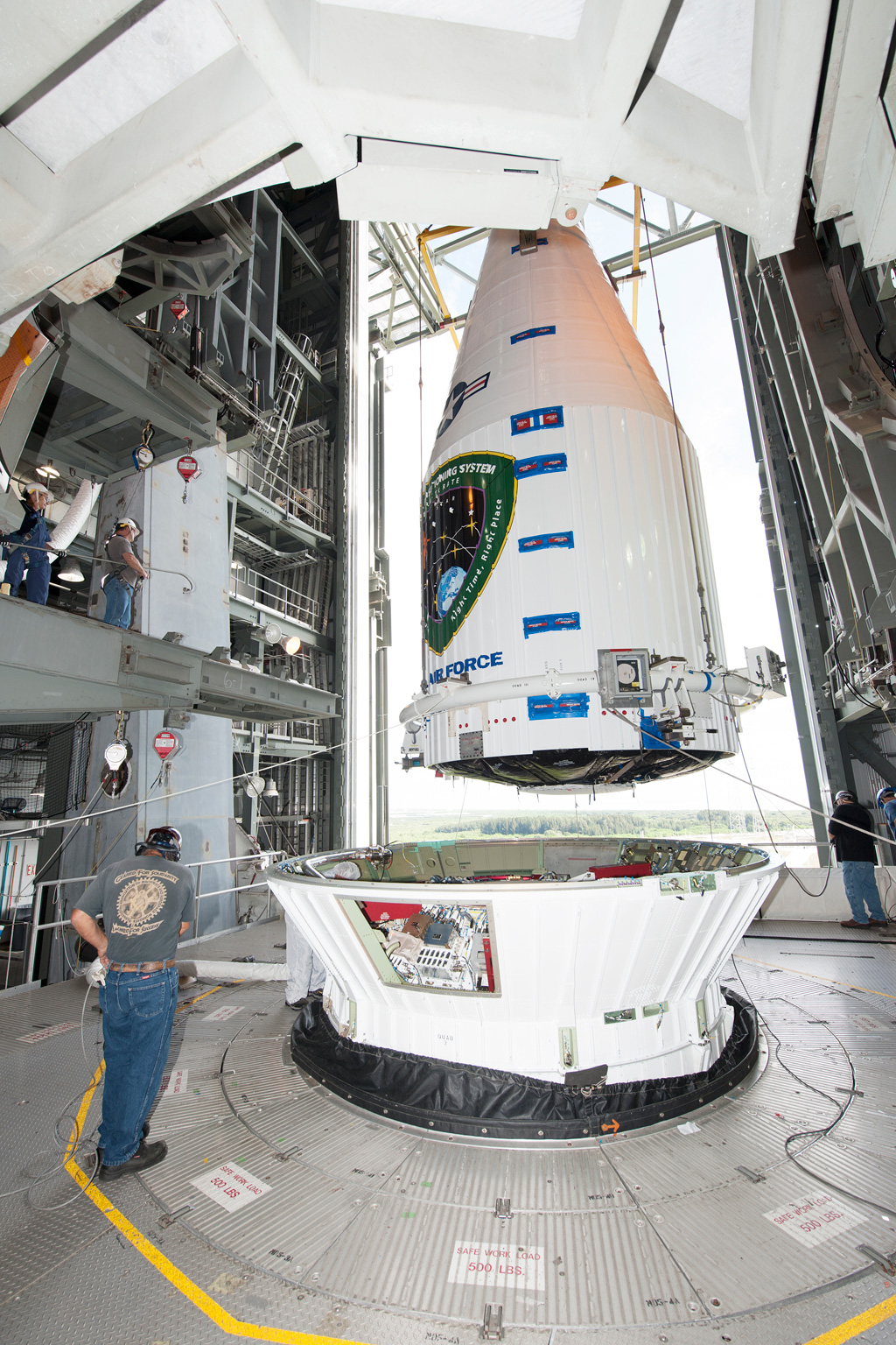
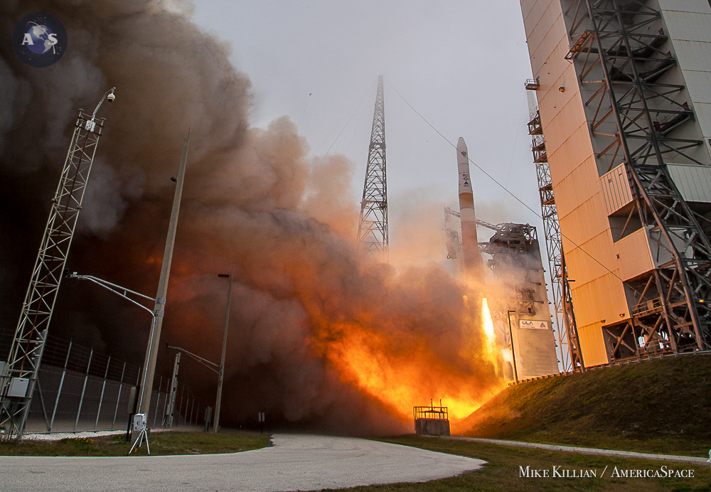
The second military mission also planned for launch from Cape Canaveral this month is the seventh USAF Wideband Global SATCOM (WGS) satellite, planned for liftoff from Complex 37B July 22 on a ULA Delta IV Medium Plus with four solid rocket boosters.
The July 22 Delta IV liftoff is scheduled within a 45-minute launch window that opens at 8:07 p.m. EDT and closes at 8:52 p.m. EDT.
The GPS and WGS launches make for a challenging operations tempo at the USAF’s 45th Space Wing that manages Cape Canaveral. Additional launches in this military space launch surge will also make for a busy pace at the 30th Space Wing at Vandenberg AFB, Calif., later this year and early next year with top secret reconnaissance flights of Intruder ocean surveillance and Topaz radar imaging spacecraft.
Both the GPS and WGS military space assets are especially important to USAF drone bandwidth and navigation during intelligence and strike operations over Iraq and Syria. And the WGS Ka-band system specifically is used to route key drone-gathered intelligence imagery to hundreds of 18-inch diameter antennas that can be carried in the rucksack of any soldier or Marine.
Also, GPS spacecraft are increasingly capable of detecting underground nuclear testing as North Korea has done and Iran could potentially do in the future.
This underground nuclear test detection capability is very important locally to the highly secret Air Force Technical Applications Center (AFTAC)—charged with nuclear treaty related reconnaissance, detection, and enforcement. AFTAC is co-located with the 45th Space Wing at Patrick AFB about 15 miles south of the Cape’s pads.
GPS satellites can do this nuclear monitoring by detecting the “traveling ionospheric disturbance” that accompanies each underground explosion, said geo engineer Dorota Grejner-Brzezinska at Ohio State University.
For example, moments after the July 25, 2009, North Korean underground nuclear weapon detonation 11 GPS receivers picked up GPS satellite data showing a sudden spike in atmospheric electron density, according to the Bulletin of Atomic Scientists.
Two more Boeing GPS 2F spacecraft will remain to be launched after 2F-10 to complete the 12 satellite line that began operation with the first 2F launched in May 2010 on a Delta IV. Each 2F has a 12-year service life.
There are eight new GPS III spacecraft planned. They are to have a 15-year design life, three times the accuracy, eight times the anti-jam capability, and much stronger signal power than the previous Boeing GPS spacecraft.
The 45th Weather Squadron forecasts that the GPS Atlas V mission should have a 70 percent chance of acceptable weather for both its July 14 Mobile Launcher rollout to Complex 41 and the launch itself on the 15th. The 30 perfect unfavorable odds come with the potential presence of excessive cumulus clouds. Given mid summer in central Florida, the weather for the WGS-7 launch July 22 will likely be similar.
Powered by 860,000 lbs (390,089 kg) of thrust from its Energomash RD-180 engine, the Atlas will fly northeast before ignition if its 24,750-lb (11,226-kg) thrust second stage Centaur Aerojet Rocketdyne RL10B-2 engine. The Atlas will place the 3,400-lb (1,542-kg) satellite into a 12,541 mi. (20,182 km.) orbit inclined 55 deg.
The new GPS will replace the 11-year-old GPS 2R-11 launched in 2004. That satellite will take on a backup role in the expanded 31 satellite GPS constellation that ensures at least 24 satellites are operational at any given time, with mostly four spacecraft in view of any given spot on Earth. As part of this change, the 19-year-old GPS 2A-26, launched in 1996, will be decommissioned.
There are about $4 billion in Air Force, Navy and National Reconnaissance Office space assets involved in the military space surge over the next six months. Atlas V launches cost about $100 million, while Delta IV Medium flights cost about $164 million. Costs involved with the sveven U. S. spacecraft involved in the surge are:
—July 15, the $245 million USAF GPS 2F-10 on an Atlas V from the Cape.
—July 22, the $566 million USAF WGS-7 on a Delta IV Medium from the Cape.
—Aug. 27, the $611 million Navy MUOS Mobile User Objective System on a Cape Atlas V.
—Sept. 25, the approximately $300-500 million class National Reconnaissance Office (NRO-55) twin Intruder secret ocean surveillance spacecraft planned for launch from Vandenberg on an Atlas V.
—Oct. 30, the $245 million GPS 2F-11 on a Cape Atlas V.
—Jan. 26, the $245 million GPS 2F-12, the final 2F mission, on a Cape Atlas V.
—Feb. 10, the approximately $1 billion NRO-45 National Reconnaissance Office Topaz 4 high resolution imaging radar that has replaced the 30-year-old Lacrosse imaging radar design.
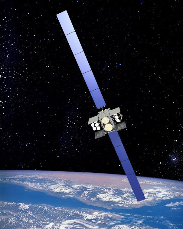
The planned July 22 launch of WGS-7 will mark the second Delta IV launch from Cape Canaveral in 2015. Each Boeing WGS is a large, powerful satellite weighing 13,000 lbs (5,897 kg), with solar arrays spanning 157 ft (48 meters).
The Delta IV will liftoff on 1.82 million lbs (825,538 kg) of thrust from its Aerojet Rocketdyne RS-68 oxygen/hydrogen engine and four solid rocket boosters. Its RL10B-2 upper stage engine will propel WGS-7 into a super synchronous orbit, then the satellite will descend to its desired secret geosynchronous orbit parking spot. It will undergo several weeks of operational testing.
The WGS system provides worldwide, flexible, high-data rate and long-haul communications for marines, soldiers, sailors, airmen, the White House Communication Agency, the U.S. State Department, international partners, and other special users. The Air Force says the WGS system forms the backbone of the U.S. military’s global satellite communications capability.
Each WGS satellite provides service in both the X- and Ka-frequency bands, with the unprecedented ability to cross-band between the two frequencies onboard the satellite. WGS augments the one-way Global Broadcast Service (GBS) service through new two-way Ka-band service.
Each WGS satellite is digitally channelized. These characteristics provide a quantum leap in communications capacity, connectivity, and flexibility for U.S. military forces and international partners, while seamlessly integrating with current and future X- and Ka-band terminals.
The Air Force says: “WGS provides essential communications services, allowing Combatant Commanders to exert command and control of their tactical forces, from peace time to military operations. Tactical forces will rely on WGS to provide high-capacity connectivity to the Defense Information Systems Network (DISN).”
International partners participating on the WGS program are Australia, Canada, Denmark, Luxembourg, The Netherlands, and New Zealand. Australia procured WGS-6 as its own dedicated wideband asset.
A WGS satellite can provide up to eight steerable and shaped X-band spot beams formed by separate transmit/receive phased array antennas. Also, it can project 10 Ka-band beams by independently steered and diplexed antennas, including three with selectable RF polarization.
Be sure to “Like” AmericaSpace on Facebook and follow us on Twitter: @AmericaSpace
Missions » GPS » GPS IIF-10 »