
UPDATE:
The first launch attempt on Jan 18 was scrubbed, below is ULA’s statement:
“Launch of Atlas V carrying the SBIRS GEO Flight 4 mission was scrubbed due to a ground issue associated with the booster liquid oxygen system. Launch is planned for Friday, Jan. 19. The forecast shows a 90 percent chance of favorable weather conditions for launch. The launch time is 7:48 p.m. ET.”
ORIGINAL STORY:
United Launch Alliance (ULA) is all systems GO for a launch attempt tonight to deliver one of the Pentagon’s highest priorities to space, the fourth U.S. Air Force Space Based Infrared System Geosynchronous Orbit (SBIRS GEO-4) spacecraft, atop an Atlas-V rocket.
Liftoff of the 194 foot tall booster, flying in a rarely seen ‘411’ configuration with a single solid rocket booster, is currently scheduled for 7:52pm EST tonight, at the opening of a 40 minute launch window. It will mark another milestone for ULA too as their 75th Atlas-V launch, which has flown with a 100% success rate. The rocket is dedicated to Erik Madison, “our dear friend” says ULA.
Weather forecast looks very good with 90% chance of favorable conditions expected at T-0 (Cumulus Clouds is the primary concern).
WATCH LIVE BEGINNING AT 7:30pm EST!
The $1.2 billion Lockheed Martin satellite is a crucial war fighting tool to detect and track missile launches worldwide, and is one of the U.S. military’s most expensive and highest priority space assets.
“SBIRS provides our military with timely, reliable and accurate missile warning and infrared surveillance information,” said Tom McCormick, vice president of Lockheed Martin’s Overhead Persistent Infrared systems mission area. “We look forward to adding GEO Flight 4’s capabilities to the first line of defense in our nation’s missile defense strategy.”
SBIRS spacecraft are directly involved in real time war fighting operations from the moment they become operational, not only because of their ability to deter a missile attack and help decisions on an immediate nuclear response, but also to see and warn of even small rocket powered artillery such as mortars, fired at the U.S. and allied forces in Iraq, Syria, and Afghanistan. That information is now being released to forces on a real-time basis.
SBIRS GEO-4 follows the Air Force’s GEO-3, which launched on January 20, 2017, and in March sent its first images back down to Earth.
From Lockheed, “The Air Force’s SBIRS includes a combination of satellites in GEO orbit and hosted payloads in Highly Elliptical Orbit (HEO). A robust, new ground control system serves as the nerve center for the entire constellation, collecting large amounts of data from the satellites’ powerful sensors and converting it into actionable reports for defense, intelligence and civil applications.”

SBIRS’s primary mission is strategic missile warning, but the system can support a wide range of research and development projects across the field of remote sensing, which is the monitoring, observing, and gathering of information on the Earth and atmosphere from space.
“By giving researchers access to this data, our objective is for them to find new, innovative uses for improving situational awareness—whether it is for tactical military missions, natural disasters or even firefighting,” said David Sheridan, vice president of Lockheed Martin’s Overhead Persistent Infrared (OPIR) systems mission area.
The SBIRS spacecraft have four missions:
- Missile Warning: To spot and calculate impact times and locations for strategic nuclear strikes from Russia, China, North Korea, or Iran or smaller tactical missiles fired at U. S. and allied forces. SBIRS also provides such coverage for Great Britain, France, Australia, and likely also Japan, and to U.S. forces based in South Korea.

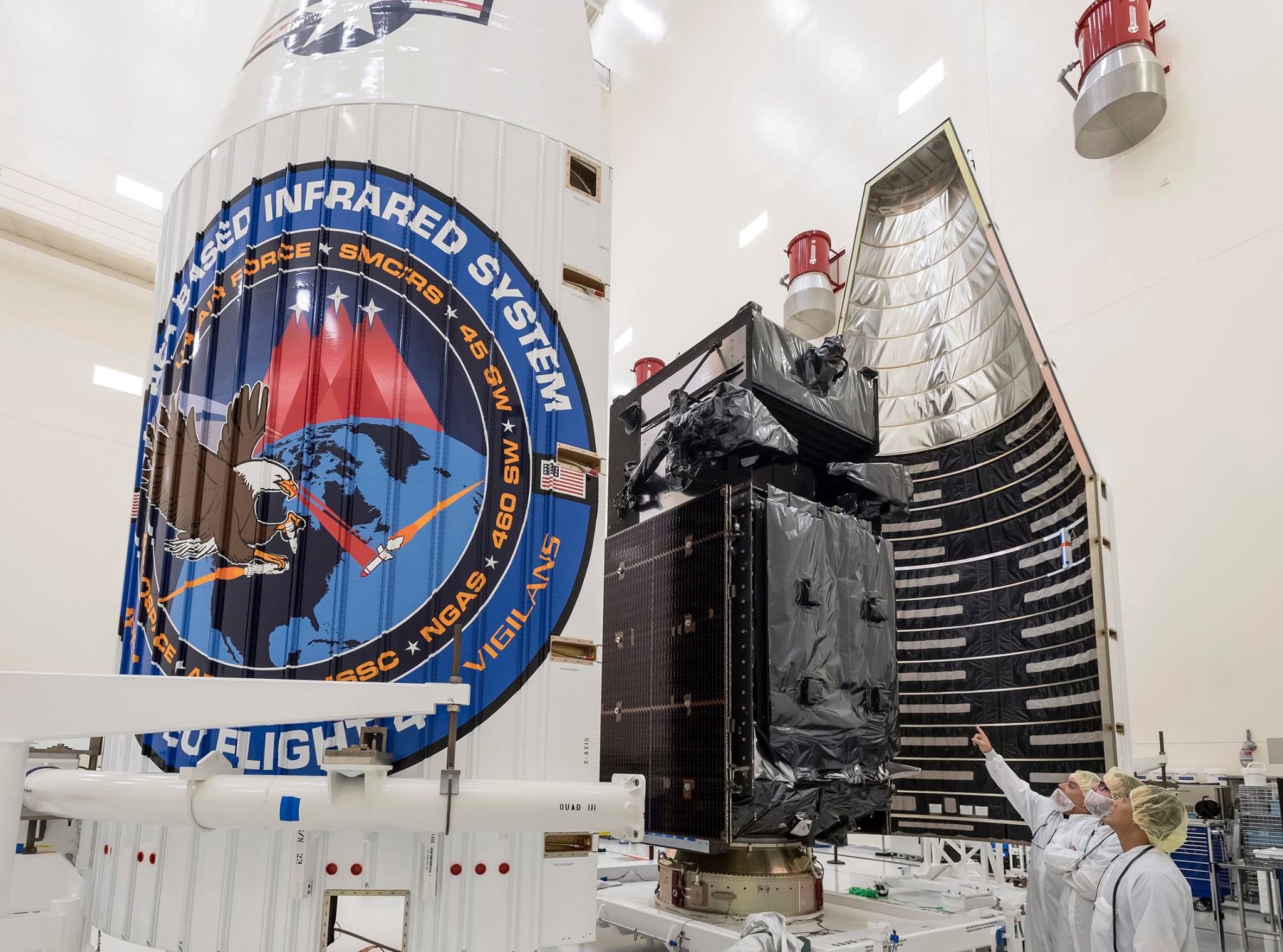
SBIRS GEO Flight 4, the next Geosynchronous Earth Orbit (GEO) satellite to join the U.S. Air Force’s Space Based Infrared System (SBIRS) during assembly and test at Lockheed Martin’s satellite manufacturing facility in Sunnyvale, California. Credit: Lockheed Martin Missile Defense: To guide decision making and employment of Missile Defense interceptors like Ground Based Interceptors based at Eielson AFB near Fairbanks, Alaska, and Vandenberg AFB, Calif., and SM-3 interceptors based on Navy destroyers, and Japanese and Australian destroyers.
Battlespace Awareness: To use comprehensive IR data to characterize battlespace conditions. In this vein in addition to missiles and impact point calculations, SBIRS are also to detect the especially hot jet engines of airborne military aircraft with hostile intent.
Technical Intelligence: By reaping huge amounts of data from missile tests made by adversaries. “The SBIRS scanning sensor provides a wide-area surveillance of missile launches and natural phenomena across the Earth, while the staring sensor observes smaller areas of interest with superior sensitivity,” said Dave Sheridan, Lockheed Martin’s SBIRS program manager. The staring sensor specifically provides data on an adversary’s rocket propulsion development in ground tests.

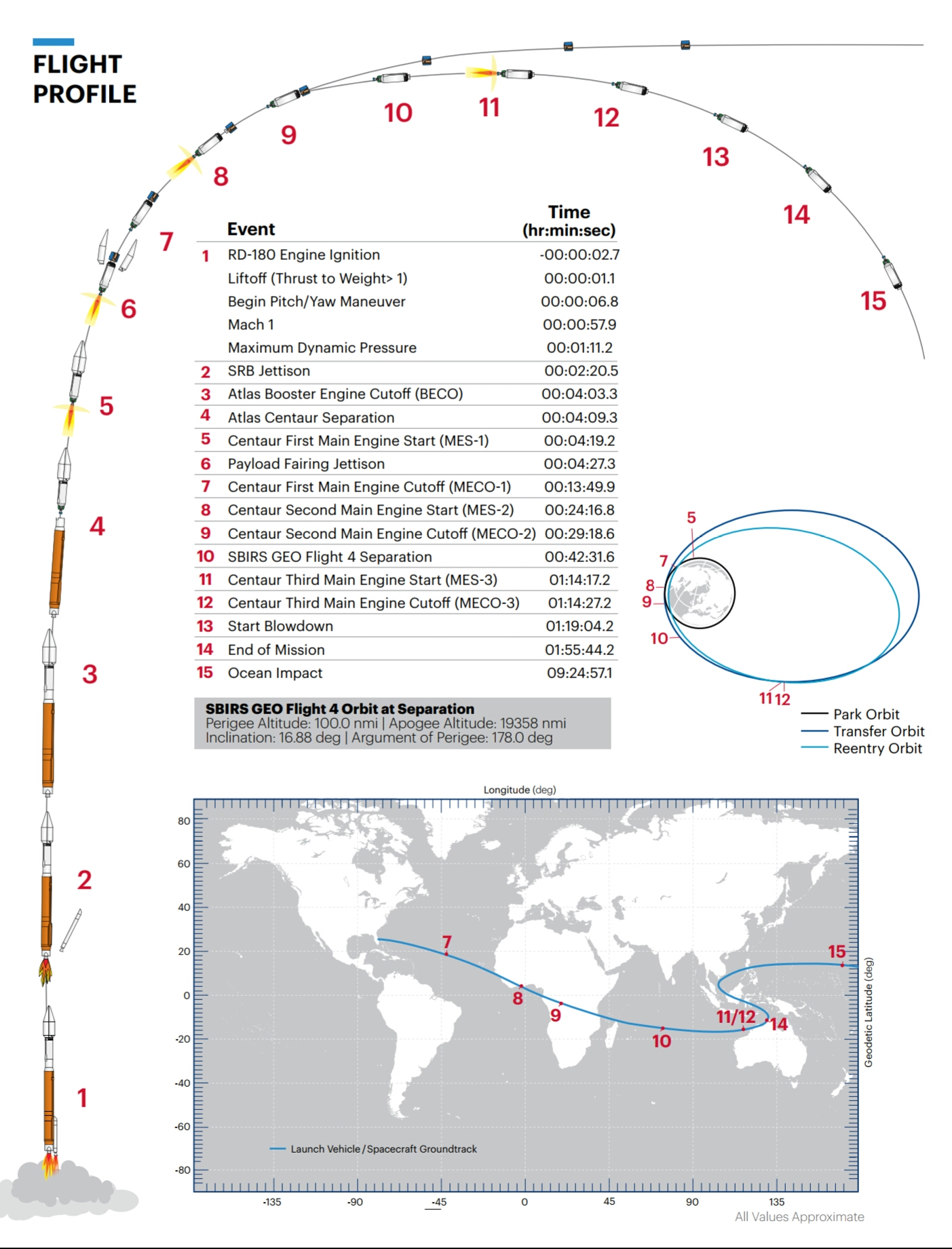
Flight profile and major milestones following Atlas-V liftoff below.
Launch of GEO 4, “will finalize the baseline SBIRS program and put worldwide SBIRS geosynchronous capability on orbit,” said Col. Dennis Bythewood, director of the Remote Sensing Systems Directorate at the Air Force’s Space and Missile Systems Center.
However, as reported previously by AmericaSpace Military Space correspondent Craig Covault, the completion of the SBIRS constellation with GEO-4 is far behind schedule and over budget.
For example, the 15,000-lb NAVY Mobile User Objective System (MUOS) cost $611 million, while the 10,000-lb SBIRS GEO satellites cost $1.2 billion a piece.
“The ambitious SBIRS GEO satellite design came to life after years of technical hurdles and cost overruns,” said Aviation Week. “A large rectangular sun shade was added to the design after engineers realized the scanning and staring sensor faces would be exposed to too much heat and glint from the Sun.”
Later, electromagnetic interference problems befuddled designers and delayed the program as did a computer processing timing issue that held up the first GEO launch, for years, said Aviation Week in a late 2015 article.

For the first time, infrared data from the Lockheed Martin satellites for new military and civilian uses at the Air Force’s recently opened data utilization lab in Boulder, Colo.
While SBIRS’s primary mission is strategic missile warning, the system can support a wide range of research and development projects across the field of remote sensing, which is the monitoring, observing, and gathering of information on the Earth and atmosphere from space.
“By giving researchers access to this data, our objective is for them to find new, innovative uses for improving situational awareness—whether it is for tactical military missions, natural disasters or even firefighting,” said David Sheridan, vice president of Lockheed Martin’s Overhead Persistent Infrared (OPIR) systems mission area.
The Air Force has seen a growing demand from the military, intelligence, and civil communities, as well as academia, for remote sensing capabilities in recent years. For areas like battlespace awareness, intelligence, and 24/7 tactical alerts, promising solutions developed in the lab will be considered for operational applications at the SBIRS Mission Control Station, OPIR Battlespace Awareness Center at Buckley Air Force Base, Colo.

“In an effort to develop, test and transition new or enhanced capabilities, the data utilization lab will provide an opportunity for users, data consumers and third-party developers to access these sensor feeds—providing an open framework architecture to host new tools, algorithms and processing solutions,” said Lt. Colonel Ross Johnston of the Air Force Space and Missile Systems Center.
Along with government and industry teams, academic organizations like the University of Colorado will use the data provided by the lab to facilitate collaboration and support research in areas that include monitoring the Earth’s surface to determine the potential for forest fires or informing critical decisions during active fires.
“The benefit of having public-private partnerships is that we can bring together different stakeholders, in addition to doing research, and understand how we can use data from space assets to solve societal issues,” said Scott Palo, associate dean for research at the University of Colorado’s College of Engineering and Applied Science. “We can also provide opportunities for students, as well as small and medium-sized businesses, to connect with industry and government and develop a broader vision that we can all build upon.”
.
FOLLOW AmericaSpace on Facebook!
.
Missions » SBIRS »