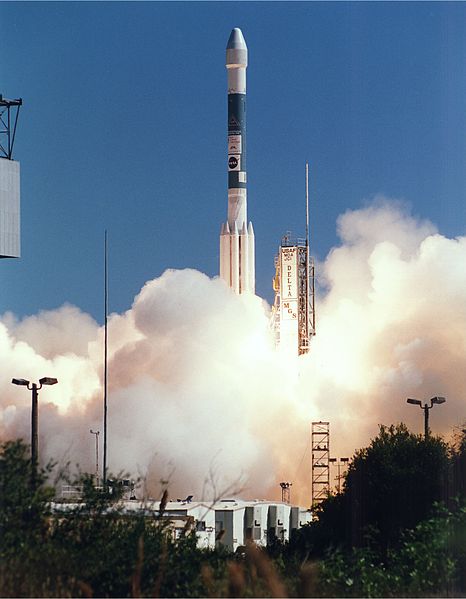
“And we have liftoff of Mars Global Surveyor, as America begins its journey back to the Red Planet,” came the announcement as a Delta II rocket thundered away from Launch Complex (LC)-17A at Cape Canaveral Air Force Station on the stroke of midday EST on 7 November 1996. The mighty Delta powered into the clear Florida sky under the combined thrust of its RS-27A first-stage engine and six of its nine strap-on, solid-fueled boosters. A couple of minutes into the ascent, the six spent boosters were jettisoned and the remaining three were “air-lit” to provide additional impulse through the low atmosphere.
With that rousing launch, 20 years ago today, Global Surveyor began what NASA described as “a sustained program of exploration” of the Red Planet. And sustained it was, for only a few weeks later, Mars Pathfinder—carrying the Sojourner rover—set off from neighboring LC-17B, atop an identical Delta II. Ten months after departing Earth, Global Surveyor reached Mars in September 1997 and went on to spend more than nine years comprehensively examining the planet from its upper atmosphere to its surface, as well as providing data-relay services for later orbiters and identifying potential touchdown spots for landers and rovers. By the time Global Surveyor ended its mission in late 2006, it had spent longer in operational service at the Red Planet than any previous robotic explorer.
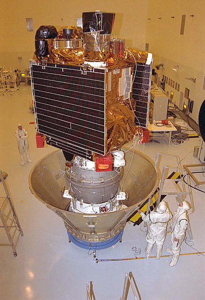
Built by Lockheed Martin, Global Surveyor followed in the footsteps of several earlier missions, but was still the United States’ first fully successful venture to Mars since the Viking era, two decades previously. In the fall of 1992, NASA had launched its Mars Observer mission to examine the planet’s atmosphere, surface, climate, and magnetic field, but contact with the spacecraft was lost in August 1993, just a handful of days before it was due to enter orbit. Notwithstanding this disappointment, the $154 million Global Surveyor carried five instruments, including a Mars Orbiter Camera (MOC) of similar design to the unit aboard the doomed Mars Observer. However, whereas Mars Observer’s camera acquired only three images of the Red Planet, that of the Global Surveyor returned no less than 243,668 images during its nine years of operations.
In addition to the MOC, with its narrow-angle and wide-angle components, the Global Surveyor was equipped with four other instruments of scientific survey. The Mars Orbiter Laser Altimeter (MOLA) would transmit infrared pulses, 10 times every second, to allow for precise topographical mapping. It also served as a passive radiometer. A six-string Thermal Emission Spectrometer (TES) would cast an infrared gaze over the surface—discovering a vast, 11,580-square-mile (30,000-square-kilometer) region in Mars’ Nili Fossae which contained the important mineral, olivine—with a combined Magnetometer and Electron Reflectometer (MAG/ER) and Ultrastable Oscillator (USO/RS) and Mars Relay (MR) Signal Receiver completing its planetary survey toolkit. Interestingly, the signal receiver would later provide data-relay support for the twin Mars Exploration Rovers (MERs), Spirit and Opportunity, during their travels across the surface from the spring of 2004.
These instruments were accommodated within a rectangular spacecraft “bus,” from which sprouted a pair of 11-foot-long (3.5-meter) electricity-generating solar arrays. The bus housed Global Surveyor’s electronics, its main computer, and its propulsion system, including maneuvering thrusters and propellant tanks. All told, the spacecraft weighed 2,337 pounds (1,060 kg) when fully fueled on launch morning.
Having been successfully inserted onto a heliocentric trajectory by the Delta II and its solid-fueled Payload Assist Module (PAM), Global Surveyor began a 308-day voyage across 466 million miles (750 million km) to reach Mars. Almost immediately, problems reared their heads, when one of the spacecraft’s solar arrays failed to correctly deploy, but was left tilted 20.5 degrees from its fully-open and latched configuration. It was not expected to have a detrimental impact on Global Surveyor’s mission, but mission controllers spent the next several months using electrically-driven positioning actuators in an attempt to gently manipulate the array into unfurling.
Meanwhile, the spacecraft performed its first trajectory maneuver, lasting 43 seconds, on 21 November 1996, as it journeyed away from Earth at 74,000 mph (119,000 km/h), relative to the Sun. By the following April, as it neared the halfway point of its outward voyage, the efforts to fully unfurl the stuck solar array had met with little success, but none of this was expected to hinder Global Surveyor’s aerobraking maneuver to enter Martian orbit. “Thanks to an early launch that gave us an advantageous trajectory, we will not have to aerobrake into the Martian atmosphere as fast as we had originally planned to reach the mapping orbit,” said Mission Manager Glenn Cunningham of NASA’s Jet Propulsion Laboratory (JPL) in Pasadena, Calif., “and that will reduce the amount of heating that the solar panels undergo during this gradual descent.”
Telemetry indicated that the “damper arm,” which formed part of the array deployment mechanism, had sheared off during Global Surveyor’s first day in space. The arrays, each of which included a Kapton flap at its tip for added drag, were expected to slow the spacecraft by 2,684 mph (4,320 km/h) during the four-month aerobraking phase. This would reduce its orbit from a highly elliptical path to a near-circular one. During the transit to Mars, engineers evaluated the problem and developed a new solar array configuration. The remainder of the cruise was largely uneventful, with a correction maneuver planned for April 1997 canceled, so precise was Global Surveyor’s outbound trajectory.
Ten months after leaving Earth, the spacecraft ignited its main engine for 22 minutes in the Mars Orbit Insertion (MOI) burn on 11 September 1997, entering a highly elliptical path, with an apoapsis of 33,570 miles (54,026 km) over the southern hemisphere and a periapsis of 163 miles (262 km) over the northern hemisphere. This initial orbit had a period of about 45 hours, with the expectation that it would be refined to a near-circular mapping orbit within about four months. However, in early October, the troubled solar array exhibited significant flexion, prompting a decision to adopt a slower, “more moderate” pace for the orbit-shaping regime. “Aerobraking will take much longer, perhaps 8-12 months, at this more gradual rate,” explained Cunningham.
As aerobraking proceeded, the scientific harvest from Mars immediately began to flow. On 16 September, just a handful of days after MOI, scientists were able to provide the first conclusive evidence of a planet-wide magnetic field, via the MAG/ER instrument. According to early data, the field’s maximum strength did not exceed 1/800ths of the field at Earth’s surface, and carried important implications for understanding Mars’ geological history. By the end of March 1998, Global Surveyor’s orbit had been reduced to an apoapsis of 11,100 miles (17,864 km) and a periapsis of 106 miles (170 km), with a period of 11.6 hours. At this stage, aerobraking was suspended for several months, as the remainder of the spacecraft’s scientific instruments were brought online and, during suitable lighting conditions, were brought to bear on examining Viking and Pathfinder landing sites from orbit.
Aerobraking resumed in September 1998 and was completed six months later, by which time Global Surveyor occupied a near-circular orbit at an altitude of 235 miles (378 km), with a period of 117 minutes. This allowed the spacecraft to commence its primary mapping cycle on 1 April 1999, during which it extensively mapped the entire Red Planet. Over the course of the next two years (or one full Martian “year”), evidence was detected of a “layered” crust, requiring the weathering, transportation, and deposition of large quantities of material, as well as a thick mantle coating over all but Mars’ very steepest slopes. Extensive cratering was observed and inferred in the northern and southern hemispheres and Global Surveyor uncovered persuasive evidence—via the presence of hematite-rich deposits—of the existence of liquid water in Mars’ distant past. Traces of planet-wide atmospheric cooling since the Viking missions were identified and, close to the surface, the spacecraft imaged the after-effects of gigantic “dust-devils” and the presence of colossal boulders.
“In some aspects, we now have better maps of Mars than we do of Earth,” exulted Project Scientist Arden Albee of California Institute of Technology in Pasadena, Calif., speaking at the end of the two-year mapping phase in January 2001. By this stage, Global Surveyor had circled Mars 8,505 times and acquired more than 58,000 images, as well as 490 million laser-altimetry readings and 97 million spectral measurements.
A year-long extended mission got underway and was itself extended in February 2002. During this lengthened phase of Martian exploration, the spacecraft routinely performed roll maneuvers to gather targeted images away from its nadir track and photographed the vast monolith on the surface of the planet’s largest satellite, Phobos. Regions of Mars’ surface which were cloaked by dust storms during the initial mapping period were re-mapped, traces of ancient, long-dried-up rivers and possible water-borne sediments were observed, and the springtime retreat of the south polar ice-cap was carefully monitored.
Astonishingly, in May 2003, Global Surveyor shuttered the first image of Earth and the Moon, as seen from Mars. From a distance of 86 million miles (139 million km), the Home Planet revealed itself as a -2.5-magnitude object, characterized by a bright patch of cloud cover over the central and eastern regions of North America. And although the far darker Moon was tougher to analyze, Global Surveyor’s images revealed slightly paler tones associated with its bright-rayed crater, Tycho.
During this extended period, NASA’s pledge of “a sustained program of exploration” was steadily realized, with the arrival of the Spirit and Opportunity rovers in the late spring of 2004. And, indeed, Global Surveyor played an integral role in their journeys across the ochre-red terrain. In September of that year, revolutionary image-compensation techniques allowed it to directly observe wheel-tracks left by Spirit at Gusev Crater. This marked the highest resolution ever obtained by a Mars-orbiting spacecraft, within 1.6 feet (0.5 meters) per pixel, far higher than the typical 4.6 feet (1.4 meters) per pixel previously achievable.
The mission was again extended for another two years in October 2004 and supported weather monitoring, which would be continued by NASA’s follow-on Mars Reconnaissance Orbiter (MRO). It also aided the selection of landing sites for the Phoenix mission and for the Curiosity rover. In the late spring of 2005, Global Surveyor became the first spacecraft to directly photograph another Mars orbiter, when it captured images of Europe’s Mars Express from a distance of 155 miles (249 km) and NASA’s Mars Odyssey from a distance of 56 miles (90 km).
Yet another two-year mission extension got underway in October 2006, but sadly Global Surveyor’s days were numbered. A month later, just days before the 10th anniversary of its launch, commands were transmitted to maneuver its solar arrays, but the spacecraft reported an error with one of its motors. On-board software transferred to a backup motor controller, but a two-day break in communication occurred on 3-4 November. Contact was re-established briefly on the 5th, during four different orbits, but no data was returned. Global Surveyor had placed itself into “safe mode” and its survival and resumption of operations depended upon restoring normal communications.
However, no further contact was established with the spacecraft, and in January 2007 NASA declared the mission to be at an end. An internal agency review found that Global Surveyor had most likely succumbed to a battery failure, triggered by a complex sequence of events involving its on-board computer memory and ground-issued commands. It was determined that depleted batteries and improper orientation of its antenna probably led to a loss of orientation control and an inability to communicate with Earth. The loss was a disappointing end to a spectacular mission which had operated longer at Mars than any previous spacecraft and which had continued to return valuable scientific data for more than four times longer than intended.
Want to keep up-to-date with all things space? Be sure to “Like” AmericaSpace on Facebook and follow us on Twitter: @AmericaSpace