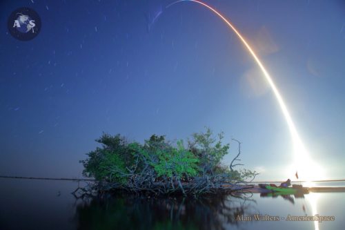
Crew Dragon soaring on Demo-1 from KSC pad 39A on March 2, 2019. Wednesday’s long-delayed flight of the Radarsat Constellation Mission (RCM) will see the second flight by the B1051 core. Photo: Alan Walters/AmericaSpace
A trio of identical satellites, each bearing the maple leaf of Canada, will rise to orbit on Wednesday, 12 June, from Space Launch Complex (SLC)-4E at Vandenberg Air Force Base, Calif., on a mission to provide comprehensive maritime surveillance, disaster management and the assessment of various ecosystems across the Arctic region. The Radarsat Constellation Mission (RCM) will also provide daily coverage of more than 90 percent of the world’s surface.
Liftoff of the Upgraded Falcon 9 booster—boasting the reflown B1051 core stage, which previously saw service on the March flight of the Crew Dragon Demo-1—is due to occur at 7:17 a.m. PDT and will kick off SpaceX’s seventh mission of 2019 and its second of the year from the West Coast. In readiness for Wednesday’s planned launch, a successful Static Fire Test of the nine Merlin 1D+ first-stage engines took place on Saturday, 8 June. Approximately nine minutes after liftoff, the B1051 core is scheduled to alight on Landing Zone (LZ)-4 at Vandenberg, marking only the second SpaceX landing on the West Coast landing pad since October 2018.
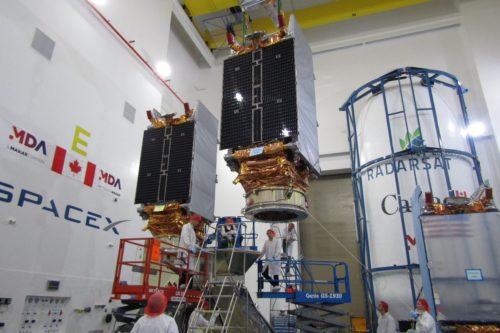
The members of the Radarsat Constellation Mission (RCM) are pictured in the process of being installed into the payload fairing of the Upgraded Falcon 9 at Vandenberg Air Force Base, Calif. Photo Credit: Canadian Space Agency
The long-awaited RCM will bring powerful C-band Synthetic Aperture Radar (SAR) capability to bear on the Canadian Arctic, providing daily revisit coverage, surveillance of ice, winds, oil pollution and shipping lanes, the early warning, response and recovery from natural disasters and the critical assessments of agriculture, forestry, wetlands and patterns of coastal change.
This will be SpaceX’s 15th flight out of Vandenberg since September 2013 and its first foray from the California launch site since it triumphantly closed out the Iridium NEXT constellation back in January 2019. In addition to the final mission for Iridium, the Hawthorne, Calif.-headquartered organization has also delivered Crew Dragon Demo-1 and the CRS-17 Dragon cargo ship to the International Space Station (ISS), together with the first operational flight of the Falcon Heavy, Israel’s ultimately-ill-fated Beresheet lunar lander and last month’s inaugural batch of Starlink internet communications satellites. Following on from the RCM launch, the next flight of the Falcon Heavy—laden with a battery of payloads for the Air Force, NASA and other customers—is due to fly from historic Pad 39A at the Kennedy Space Center (KSC) later in June.
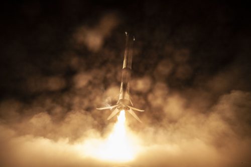
The B1051 core performs a droneship landing in March 2019, after playing its part in the launch of the Demo-1 Crew Dragon. It will fly a second time on Wednesday to launch Canada’s three-spacecraft Radarsat Constellation Mission (RCM). Photo Credit: SpaceX
Built by MacDonald Detwiler and Associates (MDA) of Richmond, British Columbia—now a subsidiary of Westminster, Colo.-based Maxar Technologies, Inc.—the RCM represents the third generation of the long-running and highly successful Radarsat program. Its first component, the 6,000-pound (2,750 kg) Radarsat-1, was launched into a 500-mile-high (800 km) Sun-synchronous orbit atop a Delta II booster from Vandenberg back in November 1995.
Equipped with a powerful SAR instrument at a single microwave frequency of 5.3 GHz in the C-band, Radarsat-1 represented Canada’s first commercial Earth observation satellite and was quickly put to use in the fields of agriculture, cartography, hydrology, forestry, oceanography, geology, ice and ocean monitoring, the detection of oceanic oil-slicks and surveillance of the Arctic Ocean region.
Its huge SAR antenna measured 49 feet (15 meters) in length and 5 feet (1.5 meters) in diameter and could cover areas of 31 x 31 miles (50 x 50 km) and achieve imaging resolutions down to just 33 feet (10 meters). Intended to remain operational for a half-decade, Radarsat-1 actually endured for more than 17 years until March 2013, when insurmountable technical difficulties in the aging satellite led it to be retired after almost quadrupling its anticipated orbital lifetime.
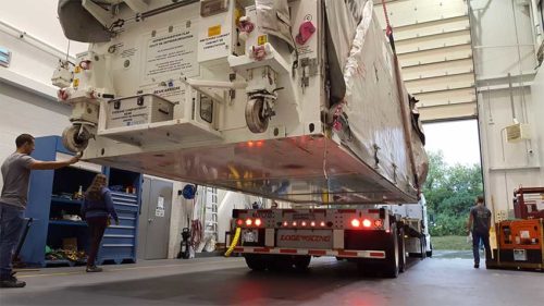
The third Radarsat Constellation Mission (RCM) satellite is offloaded by truck for final processing. Photo Credit: Canadian Space Agency
By this time, its successor, Radarsat-2, was aloft. Launched from Baikonur in Kazakhstan atop a Soyuz-FG/Fregat booster in December 2007, it occupied a similar orbit and remains active to this day, delivering imaging resolutions down to 3.3 feet (1 meter) in its “spotlight” mode and 10 feet (3 meters) in its “fine” mode. In addition to providing core capabilities in the areas of sea-ice mapping and ship-routing, iceberg detection, agricultural monitoring, marine surveillance for ships and detection of pollution, from mid-2009 onwards Radarsat-2 was put to work by the Canadian Forces for all-weather, day-and-night military surveillance of surface shipping in the Arctic, part of the Polar Epsilon project. In June 2016, MDA announced that it would extend this contract to RCM, through Polar Epsilon 2 (PE2), pledging to provide Canada’s Department of National Defence “with daily maritime information over millions of square kilometres from SAR imagery, all within minutes of imaging”.
More than a decade since Radarsat-2, the RCM mission offers a fundamental paradigm shift, with no fewer than three satellites—each weighing around 3,000 pounds (1,400 kg)—to be placed at an altitude about 370 miles (600 km) above the Home Planet, at a near-polar inclination of 97.74 degrees to the equator. Orbiting at intervals approximately 30 minutes apart, the RCM triplets will offer complete SAR coverage of the Arctic between four and six times daily, as well as the entire landmass of Canada at least once every 24 hours. The RCM’s rapid revisit capability allows it to observe the exact same view and the exact same location on Earth’s surface once every four days, as opposed to every 24 days presently achievable by Radarsat-2.
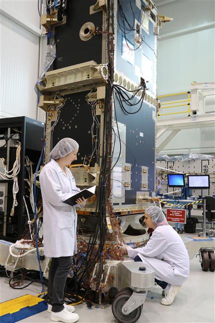
MacDonald Detwiler and Associates (MDA) engineers inspect one of the RCM satellites. Photo Credit: Canadian Space Agency
The RCM program extends back more than a decade, with initial cabinet approval from the Canadian government granted in December 2004, after which systems requirements and the overall mission concept were defined. Preliminary design of the satellites and ground segment followed and the Mission Critical Design Review (CDR) was accepted by the RCM stakeholders by November 2015. By this point, manufacturing of the satellite buses by Canada’s Magellan Aerospace Corp. had begun, with around 300 people working on the effort at its peak.
Two years ago, the structural fabrication of the satellites was completed and in May 2017 the SAR antennas were successfully tested—by means of a Super Gantry Crane to hold them and counterbalance their weight to mimic microgravity conditions of low-Earth orbit—at MDA’s facility in Montreal. During the late spring and early summer of 2018, the triplets underwent extensive Thermal Vacuum (TVAC) testing and last August Canadian Prime Minister Justin Trudeau inspected the almost-flight-ready RCM satellites and ceremonially helped install a sheet of thermal blanketing onto one of them. Between July and the end of September, the three satellites were delivered by road to the facilities of Space Systems/Loral (SS/L)—another subsidiary of Maxar—in Palo Alto, Calif., for pre-launch storage. They were then transported to Vandenberg earlier this spring.
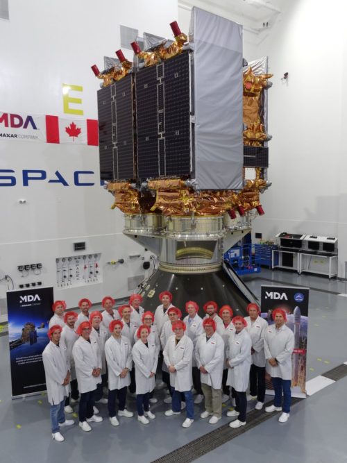
Proud MacDonald Detwiler and Associates (MDA) team-members pose in front of the RCM payloads during integration and encapsulation. Photo Credit: MDA
Owned and operated by the Canadian government, the RCM satellites are visually distinct from their two Radarsat big brothers, with much smaller SAR antennas measuring only 22 feet (6.7 meters) long by 4.6 feet (1.4 meters) wide and capable of resolutions as fine as 3.3 x 10 feet (1 x 3 meters). They also boast only a single power-producing solar panel (as opposed to two for their predecessors).
When they have placed into orbit, the RCMs are each expected to remain fully functional for around seven years. Three major areas of focus include effective marine surveillance; natural disaster management; and the protection of ecosystems. RCM data will combine Automatic Identification System (AIS) technology with radar imagery to better identify surface shipping and distinguish between open water and coastal areas. They will help to ensure safe navigation in icy waters and aid the selection of suitable sites for future wind-farms and guard against illegal fishing.
RCM will also play a role in the forewarning and mitigation of natural disasters, including floods, landslides, hurricanes and earthquake damage, as well as alerting and routing search-and-rescue teams and first responders in a timely manner. Finally, the three satellites will accurately measure crop-yield characteristics over wide areas, monitor forest harvesting and regeneration, better protect land-use around protected wildlife habitats and provide data to support the conservation of wetlands and regions directly affected by coastal erosion.
.
.
FOLLOW AmericaSpace on Facebook and Twitter!
.
.