A crystal-rich rock has been selected as the target for the Curiosity rover’s first Martian drill campaign of 2015.
Scientists leading NASA’s Curiosity Mars Science Laboratory rover have begun the process of evaluating the rock target called “Mojave.”
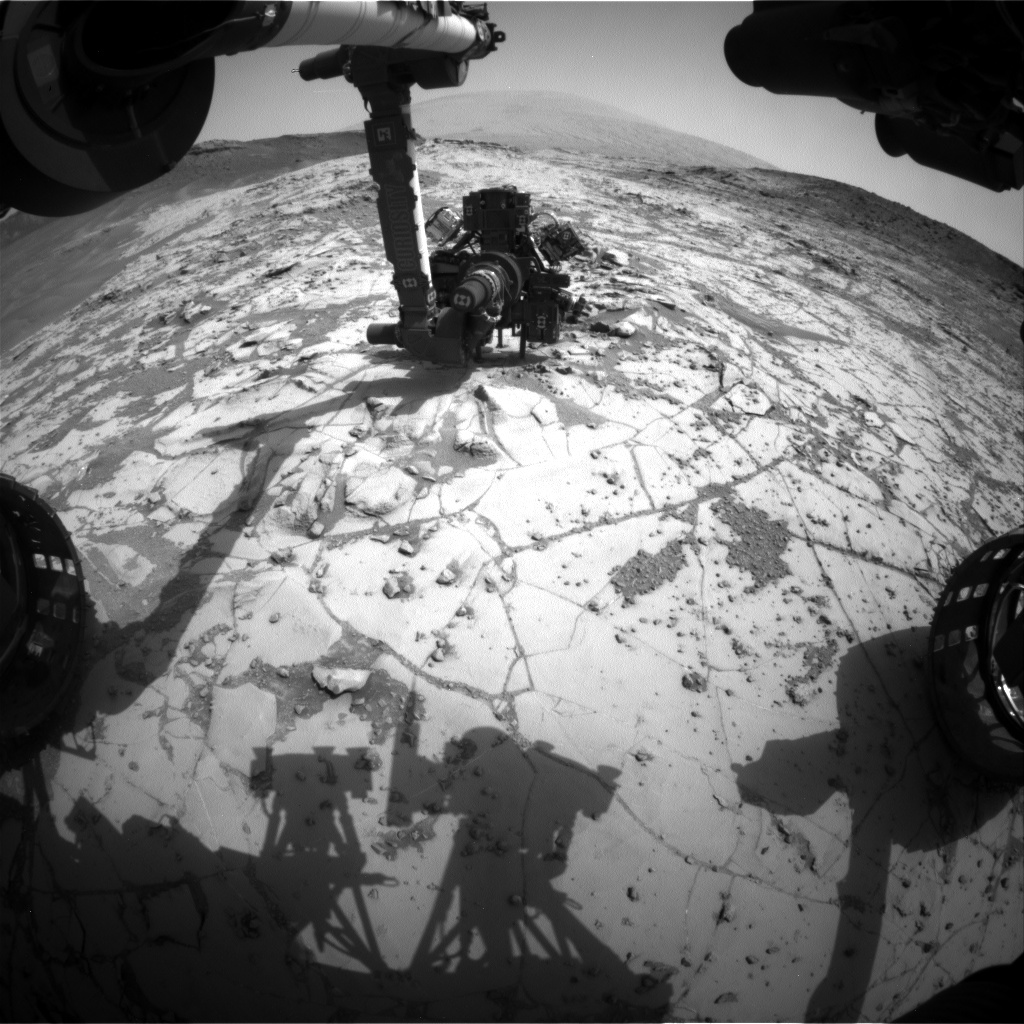
Commanding Curiosity to conduct a ‘mini-drill’ campaign was the first step in determining whether the site is suitable for full depth drilling and sample collection in coming days.
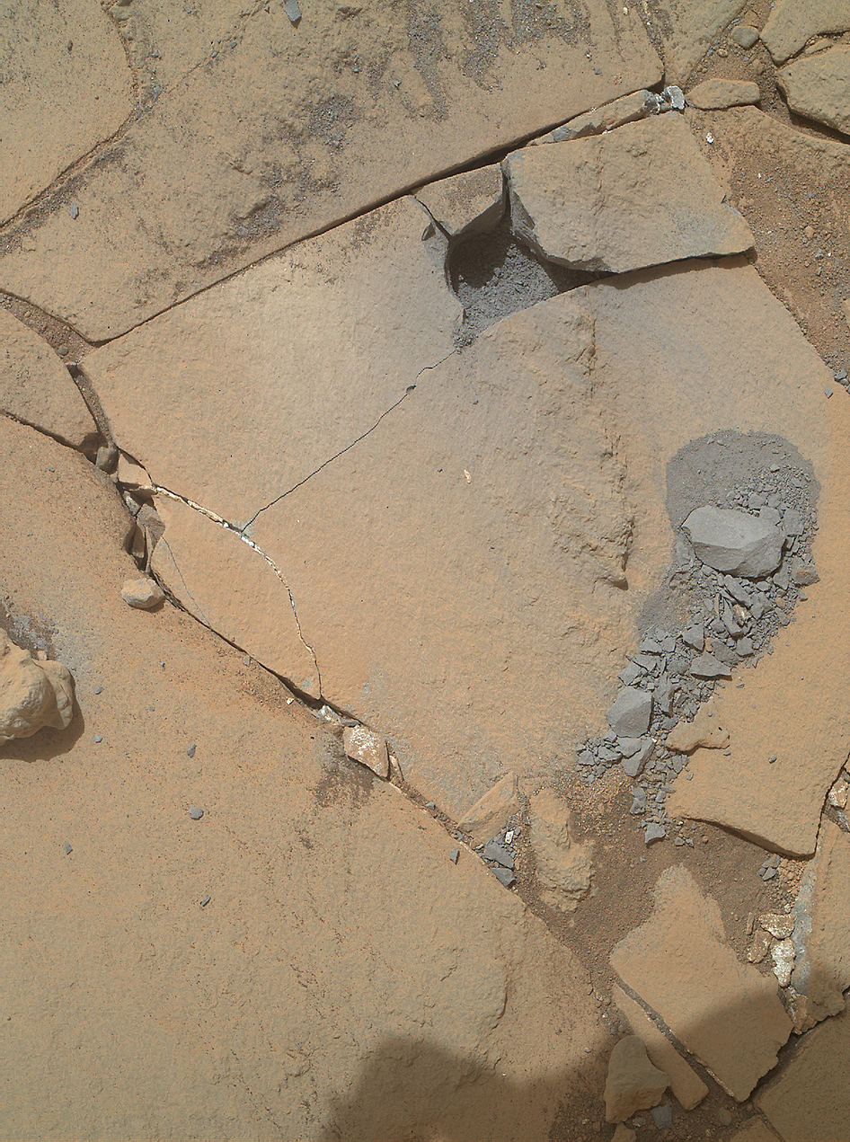
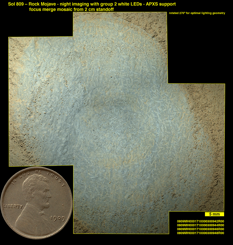
“Mojave” displays copious slender features, slightly smaller than grains of rice, that appear to be mineral crystals, say the researchers.
Lozenge-shaped crystals are clearly visible in magnified images of “Mojave” taken by the Mars Hand Lens Imager (MAHLI) instrument on the rovers arm. See image below.
The minerals could be salty residues that formed upon evaporation of ancient Martian lake and river water.
“The crystal shapes are apparent in the earlier images of Mojave, but we don’t know what they represent,” said Curiosity Project Scientist Ashwin Vasavada at NASA’s Jet Propulsion Laboratory, Pasadena, California.
“We’re hoping that mineral identifications we get from the rover’s laboratory will shed more light than we got from just the images and bulk chemistry.”
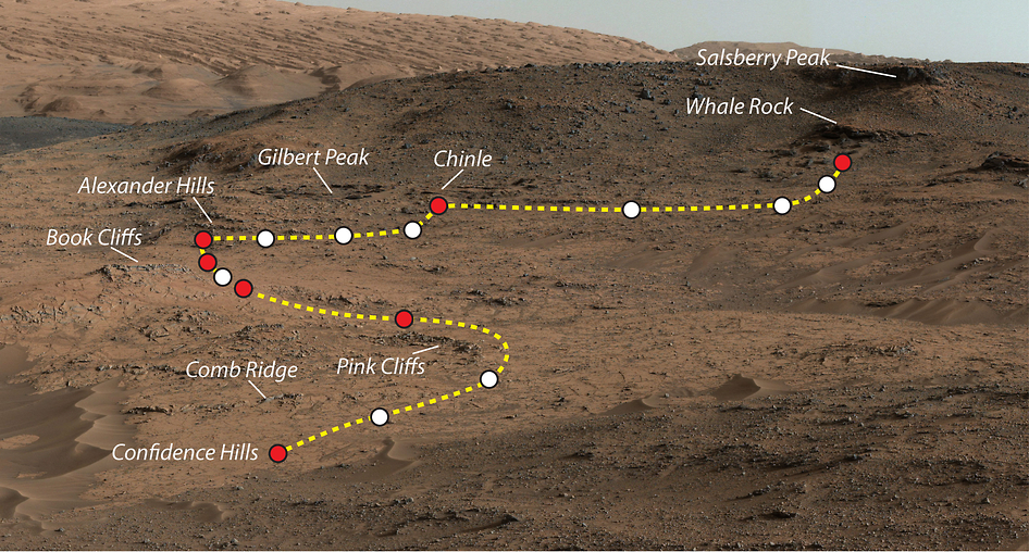
The Mojave target is in the “Pink Cliffs” area of the “Pahrump Hills” outcrop in the Murray formation at the base of Mount Sharp where the six wheeled rover has been actively investigating the past few months.
The “mini-drill” test was completed and the results are being assessed on whether to go ahead with deeper drilling and sample collecting for on-board laboratory analysis by the pair of miniaturized chemistry labs (SAM and CheMin) located in the rovers belly.
“There could be a fairly involved story here,” Vasavada said. “Are they salt crystals left from a drying lake? Or are they more pervasive through the rock, formed by fluids moving through the rock? In either case, a later fluid may have removed or replaced the original minerals with something else.”
The initial drilling operation with the rotary-percussive drill successfully cut a hole about 0.63 inch (1.6 centimeters) in diameter.
Imagery taken by the arm mounted MAHLI camera on Sol 867 (Jan. 13, 2015) confirmed the success of the mini-drill activity.
However, the test drilling also unexpectedly caused the rock to fracture, which was both good and bad news.
The good part is that the cracking resulted in rock fragments with freshly exposed surfaces of gray colored pieces.
So the drill acted as a kind of field geologists rock hammer. And the research team is now excitedly planning to take advantage of this “unusual opportunity” with an close-up examination of the exposed surfaces using the ChemCam mast mounted instrument, MAHLI and other instruments.
“The rock fragments dislodged by the mini-drill activity provided a rare opportunity to examine freshly-broken surfaces,” according to mission scientist Ken Herkenhoff of the USGS.
On the other hand, the loose rocks could endanger the robots delicate sample-collection drill – upon which all the interior rock coring, sampling and in-situ chemical analysis depend upon. So the team is now considering an alternate drill target in the same area.
“The brush will be used to clean off another potential mini-drill target, dubbed “Funk Valley,” says Herkenhoff.
“After the brushing, the drill will be “preloaded” (pushed down) against Funk Valley and a potential full drill target to determine whether the rock is strong enough to safely drill.”
Meanwhile the MAHLI camera is also being used to take the latest rover ‘selfie’ – which should be quite an exciting view.
One prior drill campaign at the “Pahrump Hills” was conducted during September 2014. The rover then conducted a “walkabout” to scout out the area for the best places to drill. “Mojave” topped the list.
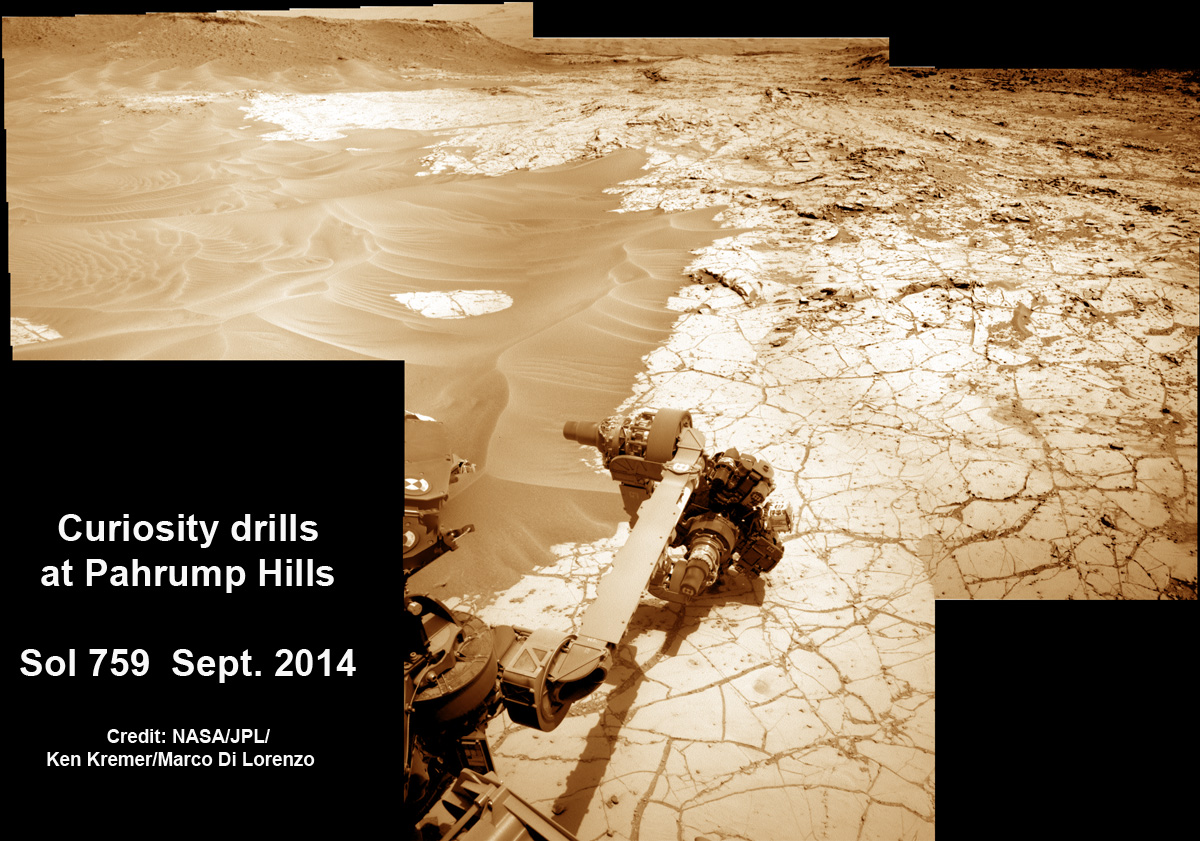
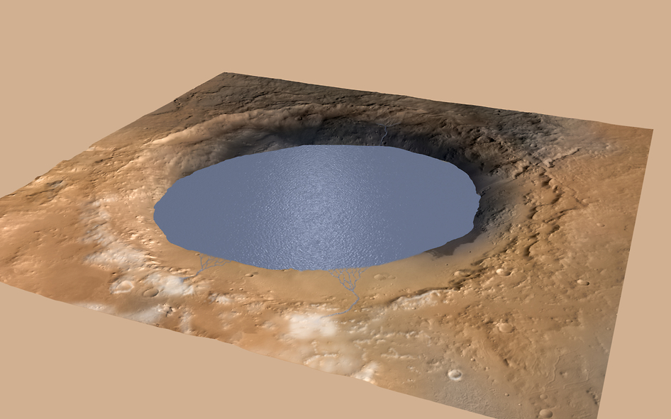
Based on multiple analysis of samples gathered during the robots prior drill campaigns, scientists have already concluded that a huge lake once filled much of the Gale Crater landing site for millions and millions of years.
Curiosity safely touched down inside Gale Crater some 29 months ago in August 2012 beside a huge, layered mountain named Mount Sharp that towers 3.4 miles (5.5 kilometers) into the Martian sky.
The discovery of a vast ancient lake at Gale and that Mount Sharp was subsequently created inside the crater by the deposition of sediments into the large lake bed over tens of millions of years, was announced during a NASA media briefing in December 2014.
This is significant because it means the Red Planet possessed the right environmental conditions for a long enough time span to significantly increase the chances that simple microbial life forms could possibly have formed and persisted on Mars billions of years ago.
“Mars changed over time,” said Vasavada at the briefing.
“Rivers and lakes were present over millions of years.”
These rivers and lakes would be the source of the salty minerals now being examined by Curiosity in the “Pahrump Hills” at the base of Mount Sharp.
Furthermore, the science team recently announced the discovery of atmospheric methane and organics in rock samples on Dec. 16, 2014 at a media briefing held at the annual meeting of the American Geophysical Union (AGU) in San Francisco, Calif. Read my detailed article – here.

So far Curiosity’s odometer totals over 5.5 miles (9.0 kilometers) since landing inside Gale Crater on Mars in August 2012. She has taken some 211,000 images during over 870 Sols of exploration.
Meanwhile older sister rover Opportunity has just climbed to the summit of Cape Tribulation along Endeavour crater as she nears her astonishing 11th anniversary roving the Red Planet!
And she captured a breathtaking panorama from the highest peak she will ever climb. See the panoramic mosaic created from raw images by Marco Di Lorenzo and Ken Kremer in my recent story – here.
Stay tuned here for continuing updates from Mars and throughout our Solar System!
Want to keep up-to-date with all things space? Be sure to “Like” AmericaSpace on Facebook and follow us on Twitter: @AmericaSpace
