“Drill, Baby, Drill” has replaced “Drive, Drive, Drive” as the Curiosity Mars rover team’s new mantra, ever since the six-wheeled behemoth pulled up to the foothills of Mount Sharp to begin the systematic layer-by-layer investigation of the humongous mountain that was envisioned years ago when it was selected as the landing site on the Red Planet.
A few sols (days) ago, NASA’s Curiosity successfully bored into a rock formation representing Mount Sharp for the first time during the rover’s existence on Mars since the nail-biting landing more than two years ago, in August 2012. The car-sized rover is now working in the extended phase of the mission.
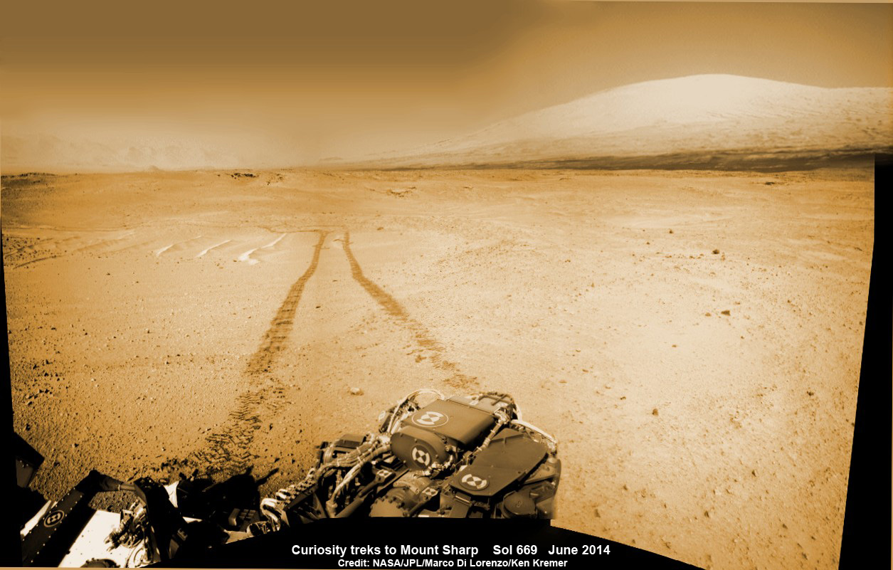
Mount Sharp was always Curiosity’s primary mission destination. The layered mountain dominates most of the Gale Crater landing site and towers 3.4 miles (5.5 kilometers) into the Martian sky and is taller than Mount Rainier.
“We’re putting on the brakes to study this amazing mountain,” said Curiosity Deputy Project Manager Jennifer Trosper of JPL, in a NASA statement. “Curiosity flew hundreds of millions of miles to do this.”
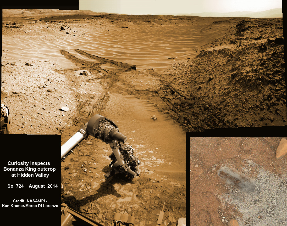
After departing the treacherous dunes of “Hidden Valley” and canceling the potential fourth drill campaign at “Bonanza King” in August for safety reasons due to an unstable rock formation, Curiosity’s handlers altered her traverse route and resumed the trek to the mountain’s base in search of a scientifically interesting new drill site.
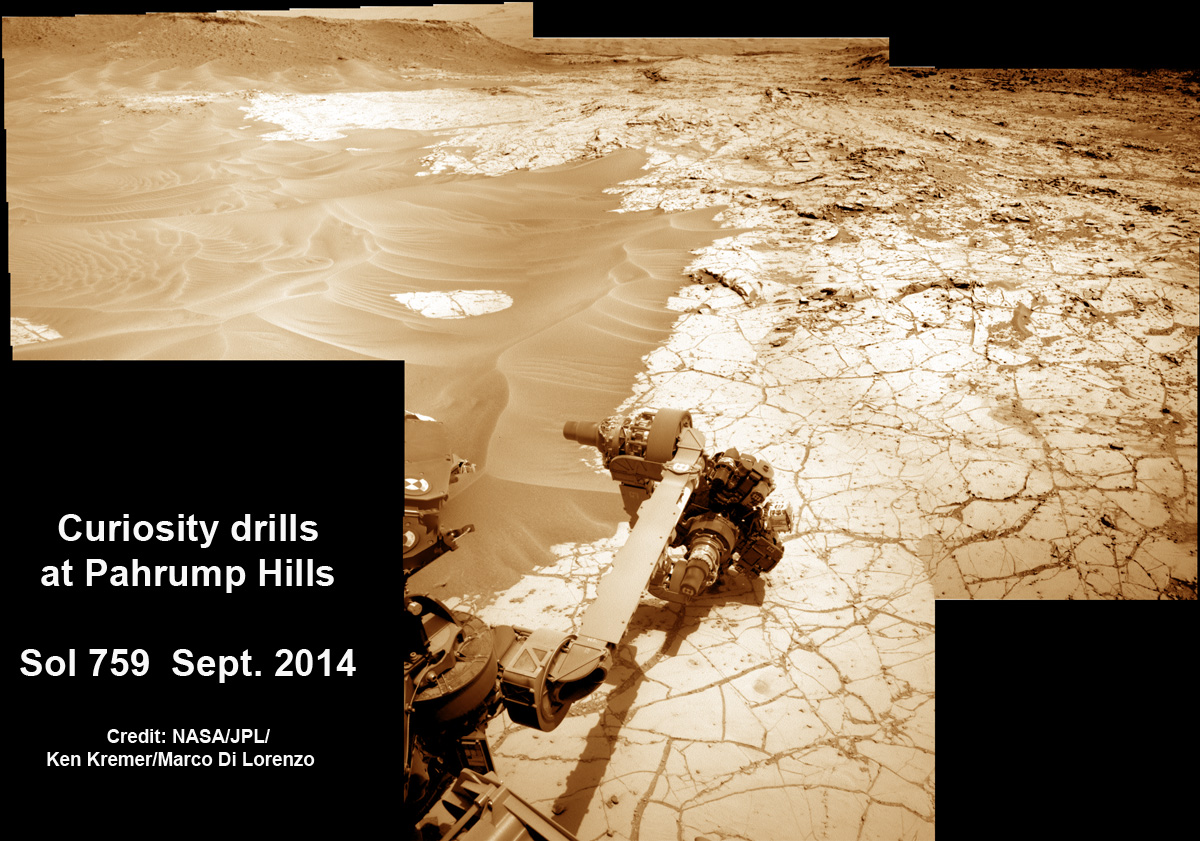
The team decided to aim for the “Pahrump Hills,” which is a section of the mountain’s basal geological unit, called the Murray formation.
“These features on the Murray formation mudstones are the accumulations of resistant materials. They occur both as discrete clusters and as dendrites, where forms are arranged in tree-like branching. By investigating the shapes and chemical ingredients in these features, the team hopes to gain information about the possible composition of fluids at this Martian location long ago,” according to NASA.
Curiosity arrived at an enticing outcrop at “Pahrump Hills” on Sept. 19 to start evaluating its feasibility as the rovers fourth drill site. Three days later the team settled on a spot named “Confidence Hills” to conduct a “mini-drill” operation, basically a shallow test hole, to further assess the target rock’s suitability for drilling.
“Confidence Hills” passed the mini-drill test with flying colors and no noticeable instability, unlike the slippery rocks at “Bonanza King.” So the engineers gave the go-ahead for full-scale interior drilling.
They also determined that the rock is softer than any of Curiosity’s three previous sample drilling/analysis targets at “John Klein,” “Cumberland,” and “Windjana.”
Curiosity’s percussion drill, located at the end of the robotic arm, successfully “chewed about 2.6 inches (6.7 centimeters) deep into a basal-layer outcrop on Mount Sharp and collected a powdered-rock sample” late in the Martian day on Sept. 24, 2014, Sol 759, according to a NASA press release.
“This drilling target is at the lowest part of the base layer of the mountain, and from here we plan to examine the higher, younger layers exposed in the nearby hills,” said Curiosity Deputy Project Scientist Ashwin Vasavada of JPL, in the NASA statement.
“This first look at rocks we believe to underlie Mount Sharp is exciting because it will begin to form a picture of the environment at the time the mountain formed, and what led to its growth.”

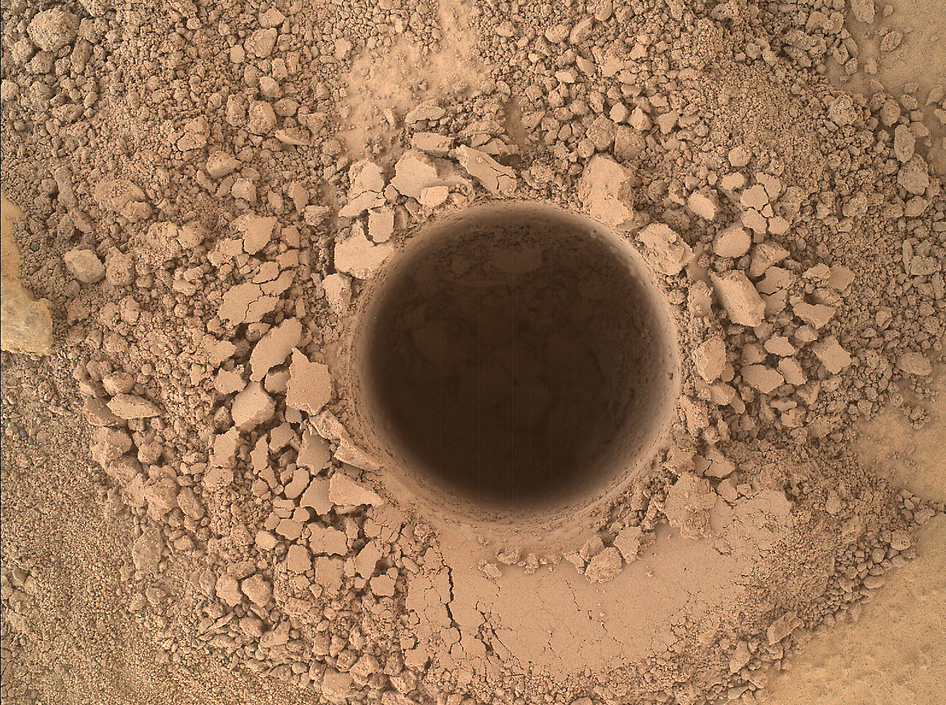
The sampling hole is approximately 0.63 inch (1.6 centimeters) in diameter and was imaged up close with the high resolution MAHLI color camera on the arm.
“The Sol 759 drill hole looks good,” reported science team member Ken Herkenhoff in a post-drill mission update.
The “Confidence Hills” hole is also being studied by the other rover’s other science instruments on the Mast and arm to fully assess whether it’s truly suitable to feed into Curiosity’s two onboard chemistry labs—SAM and CheMin—for detailed chemical compositional analysis and determination of any inorganic and organic molecules.
After collecting the rock powder it is temporarily held within the sample-handling mechanism on the rover’s arm.
At week’s end, the next step was to be the planned delivery of the rock-powder sample into the tiny scoop on the rover’s arm. But the transfer from the sample mechanism to the scoop was delayed a few days by “a problem with one of the rover’s gyroscopes,” noted Herkenhoff.
The powder transfer to the scoop is expected soon. Whenever it does happen, the drill tailings inside the open scoop will be imaged by the Mastcam color camera to determine the powder’s texture. The tailings will also be examined by the APXS and ChemCam instruments.
The team will also assess whether “it is safe for further sieving, portioning and delivery into Curiosity’s internal laboratory instruments [SAM and Chemin] without clogging hardware. The instruments can perform many types of analysis to identify chemistry and mineralogy of the source rock,” according to NASA.
In the meantime, Herkenhof said Curiosity will be put to good use. The team has commanded the one-ton rover’s SAM instrument to “heat a sample from the previous drill target ‘Windjana’ ( still held in a sample cup) and measure evolved noble gases overnight on Sols 763 and 764.”
The lower reaches of Mount Sharp are the rover’s ultimate driving objective because the sedimentary layers are believed to hold caches of water-altered minerals based on high-resolution mapping measurements obtained by the CRISM spectrometer aboard NASA’s powerful Mars Reconnaissance Orbiter (MRO), soaring overhead.
Such minerals could possibly indicate locations that sustained potential Martian life forms, past or present, if they ever existed.
“Exploring the mountain will be like traveling backwards in a time machine,” Dr. Jim Green, NASA’s Director of Planetary Sciences at NASA Headquarters, Washington, D.C., said in a recent exclusive interview with AmericaSpace.
During Year 1 on Mars, Curiosity accomplished her primary objective of discovering a habitable zone on the Red Planet that contains the chemical ingredients and a chemical energy gradient necessary to support microbial life forms in the ancient past, if they ever existed.
Curiosity found the Martian habitable zone while exploring a more than three-billion-year-old riverbed near her landing site, at an area known as Yellowknife Bay.
During 2013, Curiosity conducted the first two drill campaigns at the “John Klein” and “Cumberland” outcrop targets inside Yellowknife Bay. They were both mudstone rock outcrops and the interiors were markedly different in color and much lighter compared to the third drill site at “Windjana” into a slab of red, sandstone rock during 2014.
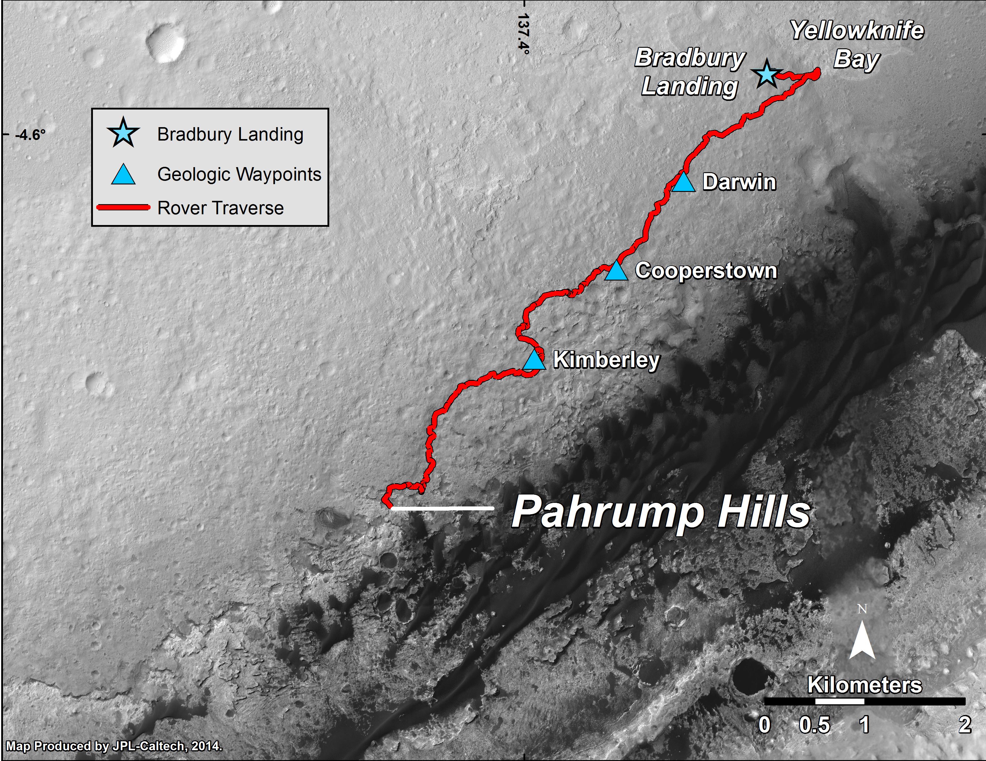
So far Curiosity’s odometer totals over 5.5 miles (9.0 kilometers) since landing inside Gale Crater on Mars in August 2012. She has taken over 191,000 images during 763 Sols of exploration.
Meanwhile MAVEN, NASA’s newest Mars orbiter, successfully entered Mars orbit barely a week ago, on Sept. 21. Read AmericaSpace’s MAVEN articles here, here, and here.
Stay tuned here for continuing updates.
Want to keep up-to-date with all things space? Be sure to “Like” AmericaSpace on Facebook and follow us on Twitter: @AmericaSpace
Now it’s getting REAL interesting! Best of luck to the scientists and engineers.