[youtube_video] http://www.youtube.com/watch?v=rQsSbLvOXjI[/youtube_video]
As NASA faces an uncertain future, the International Space Station (ISS) crews have repeatedly sent down imagery that highlights the incredible importance – and beauty of space exploration. What follows are various time-elapsed videos produced by the Expedition 30 crew and the official description of each.
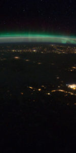
The video above was taken by the crew of Expedition 30 on board the International Space Station. The sequence of shots was taken January 29, 2012 from 10:18:13 to 10:31:28 GMT, on a pass from the North Pacific Ocean, approximately 1,000 miles west of California, to western Quebec. This video begins as the space station is passing over the dark waters of the North Pacific Ocean northeast towards Vancouver Island. The Aurora Borealis can be seen far north, where both the under side and top of the aurora are visible. The pass continues over Canada until the sun begins to come up in the east while over Quebec.
[youtube_video]http://www.youtube.com/watch?v=163d9-Ogi4o[/youtube_video]
This video was taken by the crew of Expedition 30 onboard the International Space Station. The sequence of shots was taken January 26, 2012 from 10:04:56 to 10:10:42 GMT, on a pass from North Dakota to central Quebec. This video focuses on the Aurora Borealis over Canada as the International Space Station traveled from the northern United States to eastern Canada. The aurora can be seen near the space station, and small patches of the green light can be seen dancing around.
[youtube_video]http://www.youtube.com/watch?v=jR1eAk0bA0w[/youtube_video]
This video was taken by the crew of Expedition 30 onboard the International Space Station. The sequence of shots was taken January 30, 2012 from 06:13:36 to 06:23:09 GMT, on a pass from northern Mexico to northwest New Brunswick. This video begins looking northeast over Texas, where cities like San Antonio, Houston, and the Dallas/Fort Worth area can be seen. Continuing northeast over the Great Plains states, cities like Oklahoma City, Kansas City, and St. Louis can be easily distinguished. The pass continues over the familiar shape of the Michigan Peninsula, with Chicago at the south edge of Lake Michigan. As the station continues northeast, the Aurora Borealis can be seen over Canada.
[youtube_video]http://www.youtube.com/watch?v=gFL1941xATs[/youtube_video]
This video was taken by the crew of Expedition 30 onboard the International Space Station. The sequence of shots was taken January 30, 2012 from 06:14:22 to 06:19:03 GMT, on a pass from northern Mexico, near the Texas/Mexico border, to eastern Indiana, near Cincinnati, Ohio. This pass begins as the International Space Station travels northeast looking northwest. The brighter city lights are those of the southwestern United States, like Phoenix and El Paso. The pass continues up the Great Plains, where the city lights of Oklahoma City and Tulsa can be seen before continuing northeast towards Kansas City. The last city that is easily seen is Chicago, while the Aurora Borealis is shining to the far north.
NASA has recognized the impact that these video presentations has had and has edited some to show which cities that are represented by the tiny, shining dots below.
Missions » ISS »


