To say that 2015 has been a great year for planetary exploration would be an understatement, with fantastic new discoveries from around the Solar System. From our first ever close-up look at Pluto and its moons, to more evidence for ancient lakes and rivers on Mars (and current briny streams) to weird bright spots and mountains on Ceres, to the continuing study of Saturn and its moons, notably Enceladus, to spectacular close-up views of a comet, it has indeed been quite a year.
New Horizons: Pluto Close-Up For the First Time
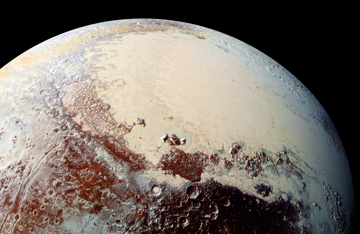
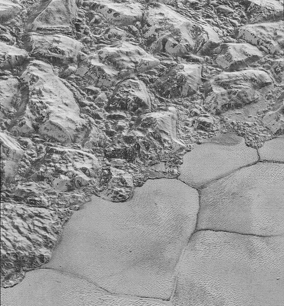
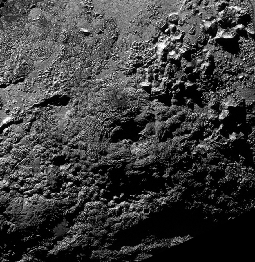
First, Pluto. For so long it was just a tiny speck of light visible in only the most powerful telescopes, and even then, no more than a small blurry dot at best. There were subtle hints of surface detail, but nothing more. Then, this year, the New Horizons spacecraft sped past this enigmatic world on July 14, providing the first good look at dwarf planet Pluto and its moons, and it was certainly worth waiting for. Far from being a geologically dead ball of ice and rock, Pluto was shown to be an active world, with huge mountains ranges and crust of solid water ice, flowing glaciers of nitrogen ice, and possibly cryovolcanoes. From above, the appearance is reminiscent of shorelines between continents and oceans, but composed of completely different materials. In places, the glacial plains are dotted with unusual swarms of small pits and odd “snakeskin” terrain can be seen elsewhere.
“These close-up images, showing the diversity of terrain on Pluto, demonstrate the power of our robotic planetary explorers to return intriguing data to scientists back here on planet Earth,” said John Grunsfeld, former astronaut and associate administrator for NASA’s Science Mission Directorate. “New Horizons thrilled us during the July flyby with the first close images of Pluto, and as the spacecraft transmits the treasure trove of images in its onboard memory back to us, we continue to be amazed by what we see.”

Some parts of Pluto’s surface are old and cratered, while others, such as the icy plains, are much younger and crater-free. Pluto is surprisingly active for a such a small world so far from the Sun.
“These new images give us a breathtaking, super-high resolution window into Pluto’s geology,” said New Horizons Principal Investigator Alan Stern, of the Southwest Research Institute (SwRI) in Boulder, Colo. “Nothing of this quality was available for Venus or Mars until decades after their first flybys; yet at Pluto we’re there already – down among the craters, mountains and ice fields – less than five months after flyby! The science we can do with these images is simply unbelievable.”
Even clearer evidence of geological processes can be seen in the newest images, including layering in some craters. It is not yet known if the layering is local, regional, or global. Dark linear features may be evidence of tectonics, according to mission scientists. There is a also a giant canyon system which stretches for hundreds of miles across the northern hemisphere.
There may even by cryovolcanoes (ice volcanoes), but those haven’t been confirmed yet.
As for Pluto’s moons, they have been found to be spinning much faster than expected. The spin rates may be chaotic (variable) due to Charon, the largest moon, exerting a strong torque that prevents each small moon from settling down into synchronous rotation.
“Pluto’s moons are behaving like spinning tops,” noted co-investigator Mark Showalter of the SETI Institute in Mountain View, Calif.
Charon also has a more active surface than previously thought, with tall mountain ridges, an unusual red-stained region at the north pole and canyons. One odd isolated mountain peak sits within a moat-like depression.
As of now, only about 25% of the data from the flyby has been returned to Earth so far; it will take until fall of next year for New Horizons to finish sending the rest. There is still a lot more to look forward to.
“It’s hard to imagine how rapidly our view of Pluto and its moons are evolving as new data stream in each week. As the discoveries pour in from those data, Pluto is becoming a star of the Solar System,” said mission Principal Investigator Alan Stern of the Southwest Research Institute, Boulder, Colo. “Moreover, I’d wager that for most planetary scientists, any one or two of our latest major findings on one world would be considered astounding. To have them all is simply incredible.”
Curiosity and Opportunity: Ancient Martian Lakes and Massive Sand Dunes
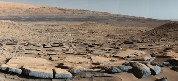
On Mars, the Curiosity and Opportunity rovers continued their exploration, providing even more evidence that the planet used to be a much wetter place than it is now. Curiosity confirmed ancient lakes in Gale crater, as well as streams. There are even gravel beds, just like ones on Earth, left over from when those streams dried up a long time ago.
“Observations from the rover suggest that a series of long-lived streams and lakes existed at some point between about 3.8 to 3.3 billion years ago, delivering sediment that slowly built up the lower layers of Mount Sharp,” said Ashwin Vasavada, Mars Science Laboratory project scientist at NASA’s Jet Propulsion Laboratory in Pasadena, Calif., and co-author of the new Science article to be published Friday, Oct. 9, 2015.
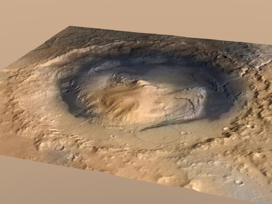
The towering Mount Sharp in the middle of the crater was partially built up from sediments from the ancient lake(s). The area where Curiosity has been roving used to be a lake bottom. Analysis suggests that the bottom layers of the mountain formed over a period of about 500 million years, built up gradually by the lakes and rivers.
“During the traverse of Gale, we have noticed patterns in the geology where we saw evidence of ancient fast-moving streams with coarser gravel, as well as places where streams appear to have emptied out into bodies of standing water,” said Ashwin Vasavada, Mars Science Laboratory project scientist. “The prediction was that we should start seeing water-deposited, fine-grained rocks closer to Mount Sharp. Now that we’ve arrived, we’re seeing finely laminated mudstones in abundance that look like lake deposits.”
From a recently published paper:
“The landforms of northern Gale crater on Mars expose thick sequences of sedimentary rocks. Based on images obtained by the Curiosity rover, we interpret these outcrops as evidence for past fluvial, deltaic, and lacustrine environments. Degradation of the crater wall and rim probably supplied these sediments, which advanced inward from the wall, infilling both the crater and an internal lake basin to a thickness of at least 75 meters. This intracrater lake system probably existed intermittently for thousands to millions of years, implying a relatively wet climate that supplied moisture to the crater rim and transported sediment via streams into the lake basin. The deposits in Gale crater were then exhumed, probably by wind-driven erosion, creating Aeolis Mons (Mount Sharp).”
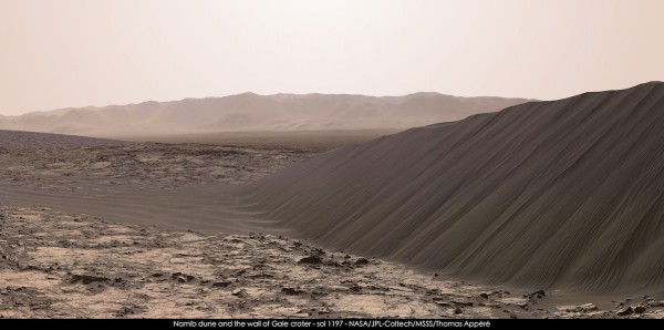
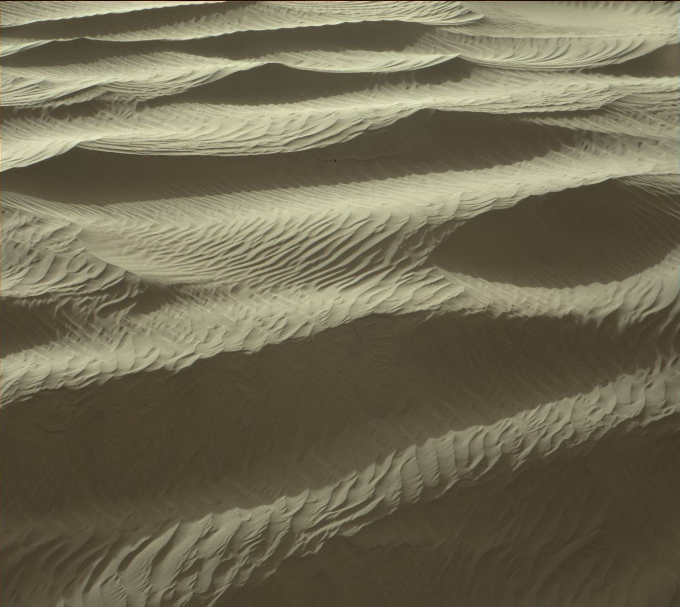
Curiosity is currently examining some of the massive dark sand dunes, called the Bagnold Dunes, which extend partway around the base of Mount Sharp. The large dunes, up to two stories tall, are themselves covered in many much smaller sand ripples, creating a very scenic view similar to deserts on Earth. As mentioned previously on AmericaSpace, the dunes here are considered to be “active” since they are still slowly migrating across the surface, as much as 3 feet (1 meter) per Earth year. Curiosity had also earlier seen ancient petrified dunes which have become hardened rock over time. The images of two of these dunes, High Dune and Namib Dune, have been some of the most spectacular of the mission so far.
Curiosity recently marked its third anniversary on Mars with other discoveries including that the region once had the chemistry required for microbial life to possibly exist, along with organics in mudstone rock outcrops. This isn’t proof of past life, but shows that the conditions could have supported it. The unusual spikes of methane in the atmosphere detected earlier by Curiosity added to the overall methane puzzle, as well. The origin of the methane is still unknown and highly debated. Curiosity is continuing to monitor the atmosphere for any further detections.
Curiosity also recently found evidence for an ancient continental crust on Mars, which may have been the precursor to plate tectonics like those on Earth. The mineralogical and chemical makeup of the rocks studied are similar to granitic continental crust rocks on Earth. The discovery is another indication of how Mars’ early history was similar to Earth’s in many ways.
Recent drilling campaigns have also found very high levels of silica, which again provide more clues about past water in this region. Some of the silica, at one rock Curiosity drilled called “Buckskin,” is in a mineral named tridymite, which is rare on Earth and never seen before on Mars. On Earth, tridymite is found in volcanic deposits with high silica content.
“These high-silica compositions are a puzzle. You can boost the concentration of silica either by leaching away other ingredients while leaving the silica behind, or by bringing in silica from somewhere else,” said Albert Yen, a Curiosity science team member at NASA’s Jet Propulsion Laboratory, Pasadena, California. “Either of those processes involve water. If we can determine which happened, we’ll learn more about other conditions in those ancient wet environments.”
“The high silica was a surprise – so interesting that we backtracked to investigate it with more of Curiosity’s instruments,” said Jens Frydenvang of Los Alamos National Laboratory in New Mexico and the University of Copenhagen, Denmark.
The Opportunity rover, meanwhile, has just entered its seventh Martian winter. Unlike previous winters however, it will be able to remain active and continue science operations.
“Our expectation is that Opportunity will be able to remain mobile through the winter,” said Mars Exploration Rover Project Manager John Callas of NASA’s Jet Propulsion Laboratory, Pasadena, Calif.
While there seemingly haven’t been as many press releases or other coverage as with Curiosity lately, the rover has quietly continued on with its business.

Opportunity finished a “walkabout” survey of its current location in Marathon Valley, which is on the rim of the huge Endeavour crater. The rover will now study rock outcrops which contain clay minerals, as identified previously from orbit, which will provide more information about past water activity in this region. Incredibly, the rover has been going strong since landing in 2004, and is still quite healthy overall.
Interestingly, rocks in “reddish zones” there contain more silica and less iron than most rocks in the area.
“We have detective work to do in Marathon Valley for many months ahead,” said Opportunity Deputy Principal Investigator Ray Arvidson, of Washington University in St. Louis. “During the Martian late fall and winter seasons Opportunity will conduct its measurements and traverses on the southern side of the valley. When spring arrives the rover will return to the valley floor for detailed measurements of outcrops that may host the clay minerals.”
One of the most picturesque images from Opportunity this year was of the “rock spire” in the small Spirit of St. Louis crater. A naturally-formed spire to be sure, but certainly a postcard-worthy sight.
Mars Reconnaissance Orbiter: Current Liquid Water on Mars
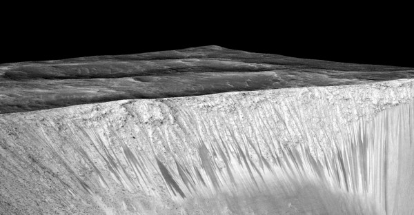
Besides the rovers, The Mars Reconnaissance Orbiter confirmed another significant discovery – that small amounts of briny liquid water still flow on the Martian surface. It had been suspected for some time that certain unusual dark streaks might be briny water flows, but this year, MRO confirmed it. Unlike other dark streaks which are simply dust avalanches, the Recurring Slope Lineae (RSL) streaks are composed of small amounts of briny (salty) water briefly running down Sun-facing slopes in the mid-latitudes and equatorial regions. MRO has observed them appearing repeatedly on an annual basis. The streaks are typically only a few meters wide, but can be several hundred meters long. Perchlorate salts help keep the water temporarily liquid in the cold, thin atmosphere before it sublimates. The actual origin of the water isn’t known yet, but could be melting ice, atmospheric deliquescence by hygroscopic salts or subsurface aquifers.
“Our quest on Mars has been to ‘follow the water,’ in our search for life in the universe, and now we have convincing science that validates what we’ve long suspected,” said John Grunsfeld, astronaut and associate administrator of NASA’s Science Mission Directorate in Washington. “This is a significant development, as it appears to confirm that water – albeit briny – is flowing today on the surface of Mars.”
“We found the hydrated salts only when the seasonal features were widest, which suggests that either the dark streaks themselves or a process that forms them is the source of the hydration. In either case, the detection of hydrated salts on these slopes means that water plays a vital role in the formation of these streaks,” said Lujendra Ojha of the Georgia Institute of Technology (Georgia Tech) in Atlanta, lead author of a report on these findings published September 28 by Nature Geoscience.
“When most people talk about water on Mars, they’re usually talking about ancient water or frozen water,” Ojha said. “Now we know there’s more to the story. This is the first spectral detection that unambiguously supports our liquid water-formation hypotheses for RSL.”
Cassini: Global Ocean on Enceladus
2015 also brought confirmation that the subsurface salty sea thought to exist on Saturn’s moon Enceladus is really a global ocean. Just like Jupiter’s moon Europa, Enceladus has a huge ocean beneath the outer icy crust. There is also now evidence for hydrothermal activity on the ocean bottom, just like on Earth.
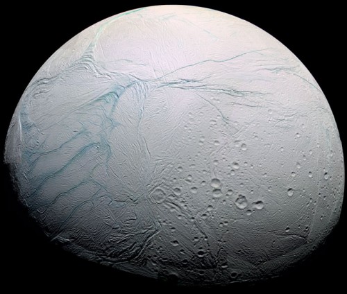
“This is a major step beyond what we understood about this moon before, and it demonstrates the kind of deep-dive discoveries we can make with long-lived orbiter missions to other planets,” said co-author Carolyn Porco, Cassini imaging team lead at Space Science Institute, Boulder, Colo. “Cassini has been exemplary in this regard.”
The Cassini spacecraft has made multiple flybys of Enceladus, even diving directly through the water vapor plumes which erupt from the south polar region. These plumes, thought to originate from the ocean below, are now known to contain water vapor, ice crystals, organics, methane and salts. The latest, and final, close flyby was on Dec. 19. The previous flyby on Oct. 28 passed only 30 miles (49 kilometers) above the surface and was the deepest dive into the plumes.
The findings make Enceladus another ocean world which is begging for further exploration. Could there be life of some kind in those dark waters?
Dawn: Weird White Spots and Mountains on Ceres
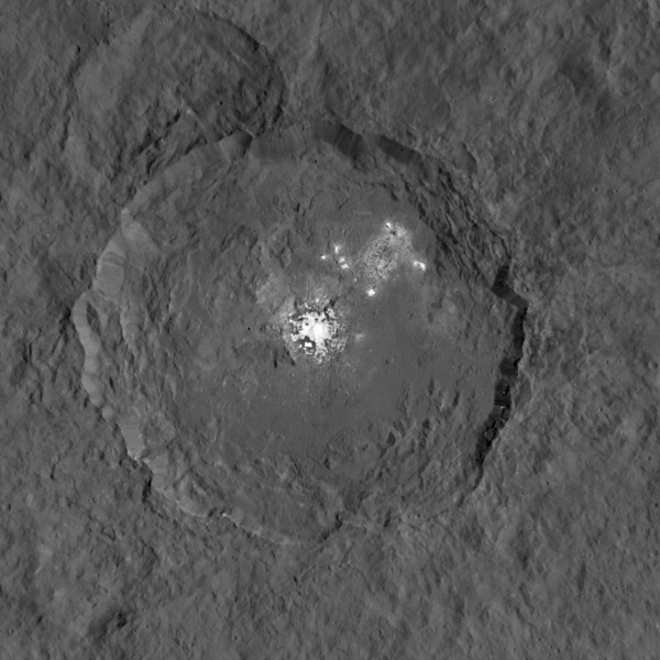
The dwarf planet Ceres was also visited for the first time this years, by the Dawn spacecraft. Like Pluto, it held surprises. One of the first things noticed were unusual bright spots in some areas, the brightest ones being in Occator crater. It’s now been determined that they are most likely salt deposits, left behind by evaporating water, originating from a subsurface layer of briny water ice. Dawn also detected haze inside Occator crater. This haze The haze is visible at noon on Ceres, but is not seen at dawn or dusk; the process may be similar to what happens on comets, when water vapor lifts tiny particles of dust and ice off the surface.
“The global nature of Ceres’ bright spots suggests that this world has a subsurface layer that contains briny water-ice,” Nathues said. He notes, however, that “The whole picture we do not have yet.”
Dawn also discovered ammonia-rich clays on Ceres. This suggests that Ceres may not have formed where it is now, in the main asteroid belt, but rather from farther out in the Solar System, where nitrogen ices are abundant.
Also like Pluto, there may be icy cryovolcanoes, but they have not been confirmed yet. Another odd feature is the so-called “Lonely Mountain,” an isolated conical mountain which is about 4 miles (6 kilometers) tall. There is nothing else like it nearby.
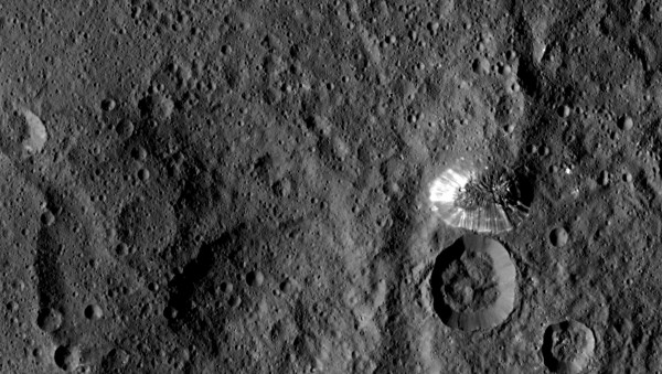
As Dawn science team member Paul Schenk, a geologist at the Lunar and Planetary Institute in Houston, Texas, described it: “This mountain is among the tallest features we’ve seen on Ceres to date. It’s unusual that it’s not associated with a crater. Why is it sitting in the middle of nowhere? We don’t know yet, but we may find out with closer observations.”
Dawn is now in its lowest orbit around Ceres, and the new images coming soon will be the best yet, starting in mid-December, with a resolution of 120 feet (35 meters) per pixel.
“Ceres continues to amaze, yet puzzle us, as we examine our multitude of images, spectra and now energetic particle bursts,” said Chris Russell, Dawn principal investigator at the University of California, Los Angeles.
Rosetta: Landing On a Comet Anniversary
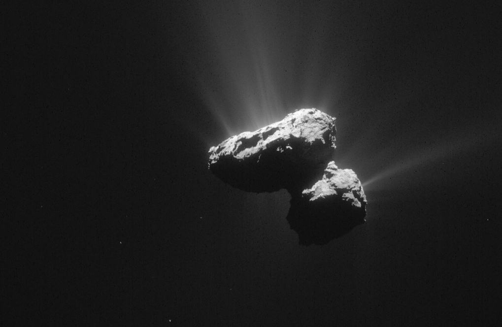
Last but not least, the Rosetta spacecraft recently celebrated the one-year anniversary since the historic touchdown of the Philae lander on the surface of Comet 67P/Churyumov-Gerasimenko. The lander bounced a couple times before finally coming to rest on the surface of the “rubber duck-shaped” comet. For the first time ever, a comet could be monitored up close as it approached closer to the Sun.
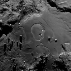
From the ESA’s summary of the findings so far:
From OSIRIS images, we see that Ma’at [a region of Agilkia], and the neighboring region Nut, are mainly covered by smooth deposits of fine-grained material. The size of these grains was revealed by the ROLIS images from Philae to be of the order of a few centimeters. Although the depth of this layer is unknown it is probably highly variable across the comet: a 35 meter-wide impact crater in the Ash region shows that the depth there may reach several meters, whereas in other places, the view across walls of more compacted material suggests that the layer is thin.”
The images of the comet, including blasting jets, have been spectacular, as Rosetta continues to orbit 67P. Rosetta has observed “dramatic and rapid changes” on the surface of the comet.
According to Olivier Groussin, an astronomer at the Laboratoire d’Astrophysique de Marseille, France, OSIRIS Co-Investigator and lead author of the new study: “We had been closely monitoring the Imhotep region since August 2014, and as late as May 2015, we had detected no changes down to scales of a tenth of a meter. Then one morning we noticed that something new had happened: the surface of Imhotep had started to change dramatically. The changes kept going on for quite a while.”
“These spectacular changes are proceeding extremely rapidly, with the rims of the features expanding by a few tens of centimeters per hour. This highlights the complexity of the physical processes involved,” added Groussin.
On July 31, the first science results from the Philae lander were released, relating to the composition of the comet, surface features and hardness, temperature, and magnetism. Philae found the surface to be “littered with coarse debris” as well as discovering “a suite of 16 organic compounds comprising numerous carbon and nitrogen-rich compounds, including four compounds – methyl isocyanate, acetone, propionaldehyde and acetamide – that have never before been detected in comets.” Philae also found the surface to be harder than expected, and did not detect any measurable magnetic field around the comet.
Rosetta also detected molecular oxygen on the comet for the first time.
According to Kathrin Altwegg of the University of Bern, and principal investigator of the ROSINA instrument, “We weren’t really expecting to detect [oxygen] at the comet – and in such high abundance – because it is so chemically reactive, so it was quite a surprise. It’s also unanticipated because there aren’t very many examples of the detection of interstellar [oxygen]. And thus, even though it must have been incorporated into the comet during its formation, this is not so easily explained by current Solar System formation models.”
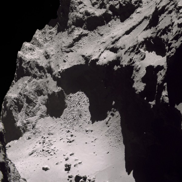
Even boulders and features resembling “sand dunes” were seen on the comet’s rough, craggy surface. It may be much smaller than planets or moons, but Comet 67P is indeed a unique world as well, and the detailed images sent back are hauntingly beautiful.
Taken all together, the results from these various missions in 2015 have been nothing short of astounding, and there will be much more to come in 2016 and beyond…
Be sure to “Like” AmericaSpace on Facebook and follow us on Twitter: @AmericaSpace
Missions » Rosetta » Missions » New Horizons »


